Vanuatu, officially the Republic of Vanuatu, is an island country in Melanesia, located in the South Pacific Ocean. The archipelago, which is of volcanic origin, is 1,750 km (1,090 mi) east of northern Australia, 540 km (340 mi) northeast of New Caledonia, east of New Guinea, southeast of Solomon Islands, and west of Fiji.
The history of Vanuatu spans over 3,200 years.
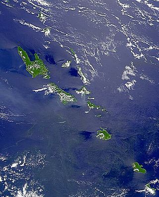
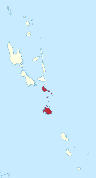
Vanuatu is a nation and group of islands in the South Pacific Ocean. It is composed of over 80 islands with 2,528 kilometres (1,571 mi) of coastline and a total surface area of 12,189 square kilometres (4,706 sq mi). It's a small country with a total size of 12,189 km2 (4,706 sq mi). Due to the spread out islands it has the 39th largest Exclusive Economic Zone of 663,251 km2 (256,083 sq mi).

Port Vila, or simply Vila, is the capital and largest city of Vanuatu. It is located on the island of Efate.

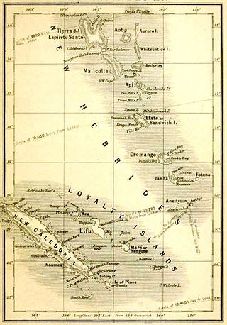
New Hebrides, officially the New Hebrides Condominium and named after the Hebrides Scottish archipelago, was the colonial name for the island group in the South Pacific Ocean that is now Vanuatu. Native people had inhabited the islands for three thousand years before the first Europeans arrived in 1606 from a Spanish expedition led by Portuguese navigator Pedro Fernandes de Queirós. The islands were named by Captain James Cook in 1774 and subsequently colonised by both the British and the French.
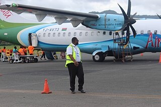
Air Vanuatu is an airline with its head office in the Air Vanuatu House, Port Vila, Vanuatu. It is Vanuatu's national flag carrier, operating to Australia, New Zealand, New Caledonia and points in the South Pacific. Its main base is Bauerfield International Airport, Port Vila.
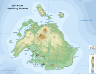
Efate is an island in the Pacific Ocean which is part of the Shefa Province in Vanuatu. It is also known as Île Vate.
Vanair was a domestic airline based in Vanuatu. The airline flew to 29 destinations on 18 of Vanuatu's 83 islands, and was wholly owned by the Vanuatu government.
Pentecost Island is one of the 83 islands that make up the South Pacific nation of Vanuatu.
Shefa is one of the six provinces of Vanuatu, located in the center of the country and including the islands of Epi and Efate and the Shepherd Islands. The province's name is derived from the initial letters of SHepherd and EFAte. It has a population of 78,723 people and an area of 1,455 km2. Its capital is Port Vila, which is also the capital of the nation.

Erromango is the fourth largest island in the Vanuatu archipelago. With a land area of 891.9 square kilometres (344.4 sq mi), it is the largest island in Tafea Province, the southernmost of Vanuatu's six administrative regions.
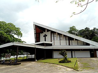
The Roman Catholic Diocese of Port-Vila in Vanuatu is a suffragan diocese of the Roman Catholic Archdiocese of Nouméa.

Severe Tropical Cyclone Ivy was a tropical cyclone that affected about 25% of the population of Vanuatu in February 2004. It was first classified as a tropical disturbance on February 21 between Vanuatu and Fiji. The system tracked northwestward, gradually organizing and intensifying. After attaining tropical storm status on February 23, Ivy strengthened more quickly as it turned southwestward toward Vanuatu. It attained peak winds of 165 km/h (103 mph) while moving over Vanuatu, making it an intense Category 4 cyclone on the Australian Region Tropical Cyclone Intensity Scale. By the time it passed through Vanuatu, Ivy had turned southeastward, and it gradually weakened while accelerating. After becoming extratropical on February 28, it passed just east of New Zealand and eventually dissipated on March 2.

Severe Tropical Cyclone Funa was the second strongest tropical cyclone during the 2007–08 South Pacific cyclone season, causing heavy flood and wind damage to areas of Vanuatu. The third tropical cyclone and second severe tropical cyclone of the season to form to the west of 160°E, Funa formed from an area of disturbed weather within the monsoon trough northeast of Vanuatu on January 16, 2008. Steadily intensifying as it moved to the east and subsequently south, Funa reached peak intensity with 10-minute sustained winds of 175 km/h (110 mph). However, the cyclone encountered unfavorable conditions as it progressed further south, before transitioning into an extratropical cyclone on January 21.

The 1986–87 South Pacific cyclone season was an event in the annual cycle of tropical cyclone formation. A total of 13 tropical cyclones developed during the season.

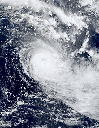
Severe Tropical Cyclone Pam was the second most intense tropical cyclone of the South Pacific Ocean in terms of sustained winds and is regarded as one of the worst natural disasters in the history of Vanuatu. A total of 15–16 people lost their lives either directly or indirectly as a result of Pam with many others injured. The storm's impacts were also felt, albeit to a lesser extent, to other islands in the South Pacific, most notably the Solomon Islands, Tuvalu, and New Zealand. Pam is the third most intense storm of the South Pacific Ocean according to pressure, after Winston of 2016 and Zoe of 2002. It is also the second most intense tropical cyclone in 2015, only behind Hurricane Patricia. In addition, Pam is tied with Orson, Monica, Marcus and Fantala for having the second strongest ten-minute maximum sustained winds in the Southern Hemisphere. Thousands of homes, schools and buildings were damaged or destroyed, with an estimated 3,300 people displaced as a result.
Severe Tropical Cyclone Paula was a tropical cyclone which caused extensive damage to areas of Vanuatu. The cyclone was the second cyclone and only severe tropical cyclone of the relatively inactive 2000–01 South Pacific cyclone season. Cyclone Paula developed from an area of disturbed weather embedded within a monsoon trough on February 25, 2001, near Vanuatu. Situated in an area of favorable conditions, Paula steadily intensified as it moved in a general direction towards the southeast. On March 1, Paula reached peak intensity with winds of 175 km/h (109 mph), sustained for ten minutes. However, the cyclone began to accelerate further to the southeast into more unfavorable conditions. As a result, Paula quickly weakened, and thus degenerated into an extratropical cyclone on March 4.

The Presbyterian Church of Vanuatu, or the Presbitirin Jyos Blong Vanuatu in Bislama, is the largest Christian denomination in Vanuatu.
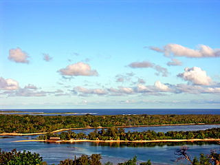
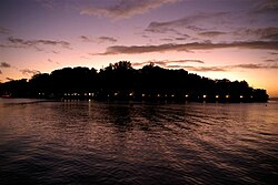
Erakor Island is a small island in the Pacific Ocean on the outskirts of Port-Vila, belonging to the Shefa Province of Vanuatu. The island is home to the Erakor Island Resort and Spa, and is a popular destination for western tourists.
Ni-Vanuatu nationality law is regulated by the 1980 Constitution of Vanuatu, as amended; the 1980 Citizenship Act, and its revisions; and various international agreements to which the country is a signatory. These laws determine who is, or is eligible to be, a national of Vanuatu. Ni-Vanuatu nationality is typically obtained under the principle of jus sanguinis, i.e. by birth in Vanuatu or abroad to parents with ni-Vanuatu nationality. It can be granted to persons with an affiliation to the country, or to a permanent resident who has lived in the country for a given period of time through naturalisation. Vanuatu has had several programs that grant honorary citizenship by investment. Nationality establishes one's international legal identity as a member of a sovereign nation. Though it is not synonymous with citizenship, for rights granted under domestic law for domestic purposes, the United Kingdom, and thus the commonwealth, have traditionally used the words interchangeably.