Banks Islands

Last updated • 4 min readFrom Wikipedia, The Free Encyclopedia
The Banks Islands Banks Islands-en.svg
The Banks Islands

The Banks Islands (in Bislama Bankis) are a group of islands in northern Vanuatu. Together with the Torres Islands to their northwest, they make up the northernmost province of Torba. The island group lies about 40 km (25 mi) north of Maewo, and includes Gaua and Vanua Lava, two of the 13 largest islands in Vanuatu. In 2009, the islands had a population of 8,533. [1] The island group's combined land area is 780 km2 (300 sq mi).

Contents

Geography

The largest island is Gaua (formerly called Santa Maria), which has a rugged terrain, rising to Mount Gharat, an active volcano at the centre of the island, at 797 m (2,615 ft). Gaua's freshwater Lake Letas, in its volcanic crater, is the largest lake in Vanuatu. A slightly smaller island in the group, Vanua Lava, is higher, at 946 m (3,104 ft); it too has an active volcano: Mount Suretamate (also spelled Süretimiat or Sere'ama, 921 m (3,022 ft)). To the east of Vanua Lava are two islets in the groupo, Ravenga and Kwakea (also spelled Qakea). Sola, the provincial capital, is on Vanua Lava. The third largest island in the group, Ureparapara (also known as Parapara), is an old volcanic cone that has been breached by the sea, forming a bay, known as Divers Bay, on its east coast.

To the east of these larger islands lie a number of smaller ones. The furthest north of them, 50 km (31 mi) northeast of Ureparapara, is Vet Tagde (also known as Vot Tande or Vat Ganai), which is an extinct volcano that last erupted 3.5 million years ago. Other small islands in this eastern chain in the Banks Island group include the Rowa Islands (also called the Reef Islands), which are a few very small, low islands on a coral atoll. Mota Lava is the largest and highest (411 m) of this eastern chain of islands; off its southern coast, attached by high corals that can be waded through at low tide, is the tiny islet of Ra. The islands of Mota, Merig, and Merelava complete the southeastern part of the archipelago.

Islands

Island nameArea
(km2)
PopulationCapitalPeakHeight
(meter)
MunicipalityCoordinates
Vot Tande 0.24--...76Mota Lava 13°15′33″S167°38′34″E / 13.25917°S 167.64278°E / -13.25917; 167.64278 (Vot Tande)
Ureparapara 39437Ley (Lesereplag)Mt Towlap764Ureparapara 13°32′S167°20′E / 13.533°S 167.333°E / -13.533; 167.333 (Ureparapara)
Vanua Lava 3302623 Sola Mt Suretamate921Vanua Lava 13°48′S167°28′E / 13.800°S 167.467°E / -13.800; 167.467 (Vanua Lava)
Mota 9.5683VeveraoMt Tawe411Mota 13°51′S167°42′E / 13.850°S 167.700°E / -13.850; 167.700 (Mota)
Mota Lava 311451LahlapMt Tuntog243Mota Lava 13°39′S167°42′E / 13.650°S 167.700°E / -13.650; 167.700 (Mota Lava)
Ra (Aya)0.5189Ra......Mota Lava 13°43′S167°37′E / 13.717°S 167.617°E / -13.717; 167.617 (Mota Lava)
Mere Lava 15647TasmateMt Teu (Star Peak)833Mere Lava 14°27′S168°4′E / 14.450°S 168.067°E / -14.450; 168.067 (Méré Lava)
Gaua 3302491Jolap Mt Gharat 767Gaua 14°15′54″S167°31′12″E / 14.26500°S 167.52000°E / -14.26500; 167.52000 (Gaua)
Merig 0.512Levolvol...125Mere Lava 14°19′S167°48′E / 14.317°S 167.800°E / -14.317; 167.800 (Mérig)
Rowa (Reef Islands)0.1--...2Mota Lava 13°37′S167°31′E / 13.617°S 167.517°E / -13.617; 167.517 (Rowa)
Banks Islands7808.533SolaMt Suretamate9216 municipalities [2] 13°55′S167°34′E / 13.917°S 167.567°E / -13.917; 167.567 (Banks-Inseln)

Economy

The principal economic activity is subsistence agriculture, although copra, coffee and (on Gaua) cacao are grown for export. The sulphur deposits of Mount Suretamate on Vanua Lava were formerly worked by a French company. Tourism is increasingly important on the islands, which can be reached by airplane.

Transport

There are airports on Mota Lava, Vanua Lava and Gaua, served by Air Vanuatu, which operates a few flights each week and Air Taxi Vanuatu as requested. Ships come to these islands, principally to pick up the products being exported, but they will also take passengers.

History

Tree fern statue of a spirit from Gaua, 19th century Tamat doro Louvre MH 90-27-2.jpg
Tree fern statue of a spirit from Gaua, 19th century

Like the rest of Vanuatu, the Banks Islands were first settled around the 12th century BCE by Austronesian navigators belonging to the Lapita culture. Archaeologists have found ancient obsidian in Motalava, Vanua Lava and Gaua, and they have found Lapita pottery on Motalava. [3] [4]

Between 25 and 29 April 1606, the Banks Islands became the first part of Vanuatu to be discovered by a European explorer: A Spanish expedition led by the Portuguese explorer Pedro Fernández de Quirós sailed past Merelava and stopped at Gaua before landing on Espiritu Santo and establishing a short-lived colony there. Merelava was charted as San Marcos, Mota Lava as Lágrimas de San Pedro (St. Peter's tears), Vanua Lava as Portal de Belén (Stable at Bethlehem), and Gaua as Santa María. [5]

Captain James Cook explored Vanuatu in 1774, and believed he had seen the whole chain, but he did not see the Banks Islands. They were explored by William Bligh, of the British Navy, and named after his patron, Sir Joseph Banks. They were charted by Matthew Flinders. Vanua Lava was first explored by a New Zealand bishop, George Augustus Selwyn in 1859.

Languages

The 15 languages of the Banks Islands
IslandLanguage# speakers
Ureparapara Lehali 200
Ureparapara Löyöp 240
Motalava Volow 1
Motalava Mwotlap 2100
Vanua Lava Lemerig 2
Vanua Lava Vera'a 500
Vanua Lava Vurës 2000
Vanua Lava Mwesen 10
Mota Mota 750
Gaua Nume 700
Gaua Dorig 300
Gaua Koro 250
Gaua Olrat 3
Gaua Lakon 800
Merelava Mwerlap 1100

The inhabitants of the Banks Islands speak 15 different languages. [6] [7] Several are endangered, being spoken by no more than a few hundred — and, in some cases, no more than a handful - of last speakers.

All of these languages belong to the Oceanic subgroup of the Austronesian language family. [8]

Notes

  1. "2009 National Census of Population and Housing: Summary Release" (PDF). Vanuatu National Statistics Office. 2009. Retrieved Nov 23, 2010.
  2. Citypopulation: Vanuatu: Verwaltungsgliederung
  3. Bedford & Spriggs (2008)
  4. Reepmeyer (2009 :86)
  5. Kelly, Celsus, O.F.M. La Austrialia del Espiritu Santo. The Journal of Fray Martín de Munilla O.F.M. and other documents relating to the Voyage of Pedro Fernández de Quirós to the South Sea (1605-1606) and the Franciscan Missionary Plan (1617-1627) Cambridge, 1966, p.39, 62.
  6. See François (2012).
  7. Detailed list and map of the Banks and Torres languages.
  8. See François (2011).

Related Research Articles

<span class="mw-page-title-main">Lapita culture</span> Neolithic archaeological culture in the Pacific

The Lapita culture is the name given to a Neolithic Austronesian people and their distinct material culture, who settled Island Melanesia via a seaborne migration at around 1600 to 500 BCE. The Lapita people are believed to have originated from the northern Philippines, either directly, via the Mariana Islands, or both. They were notable for their distinctive geometric designs on dentate-stamped pottery, which closely resemble the pottery recovered from the Nagsabaran archaeological site in northern Luzon. The Lapita intermarried with the Papuan populations to various degrees, and are the direct ancestors of the Austronesian peoples of Polynesia, eastern Micronesia, and Island Melanesia.

<span class="mw-page-title-main">Torba Province</span> Province of Vanuatu

Torba is the northernmost and least populous province of Vanuatu. It consists of the Banks Islands and the Torres Islands.

<span class="mw-page-title-main">Torres Islands</span> Island chain in Torba Province, Vanuatu

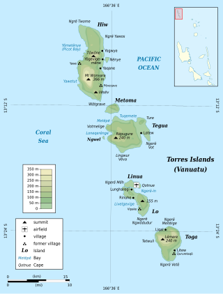
The Torres Islands are an island chain in the Torba Province of the country of Vanuatu, the country’s northernmost island group. The chain of islands that make up this micro-archipelago straddles the broader cultural boundary between Island Melanesia and several Polynesian outliers located in the neighbouring Solomon Islands. To the island chain’s north is Temotu Province of the Solomon Islands, to its south is Espiritu Santo, and to its southeast are the Banks Islands. To the west, beneath the ocean surface, is the deep Torres Trench, which is the subduction zone between the Australian Plate and Pacific Plate.

<span class="mw-page-title-main">Gaua</span> Island in Vanuatu

Gaua is the largest and second most populous of the Banks Islands in Torba Province in northern Vanuatu. It covers 342 km2.

<span class="mw-page-title-main">Vanua Lava</span> Island in Vanuatu

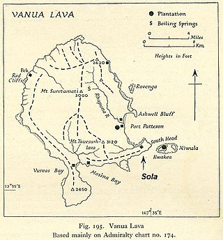
Vanua Lava is the second largest of the Banks Islands in Torba Province, Vanuatu, after slightly larger Gaua.

Mwotlap is an Oceanic language spoken by about 2,100 people in Vanuatu. The majority of speakers are found on the island of Motalava in the Banks Islands, with smaller communities in the islands of Ra and Vanua Lava, as well as migrant groups in the two main cities of the country, Santo and Port Vila.

<span class="mw-page-title-main">Mota Lava</span> Island in Vanuatu

Mota Lava or Motalava is an island of the Banks group, in the north of Vanuatu. It forms a single coral system with the small island of Ra.

<span class="mw-page-title-main">Mota (island)</span> Island in Vanuatu

Mota is an island in the Banks group of northern Vanuatu. Its population – today about 700 people – speak the Mota language, which Christian missionaries of the Anglican Church used as a lingua franca in parts of Melanesia.

<span class="mw-page-title-main">Ureparapara</span> Island of Vanuatu

Ureparapara is the third largest island in the Banks group of northern Vanuatu, after Gaua and Vanua Lava.

The North Vanuatu languages form a linkage of Southern Oceanic languages spoken in northern Vanuatu.

<span class="mw-page-title-main">Kwakéa</span> Island in Torba Province, Vanuatu

Kwakéa is an islet located east of Vanua Lava in the Banks Islands, Vanuatu. It has a population of 8 people.

<span class="mw-page-title-main">Merelava</span> Island in Vanuatu

Merelava is an island in the Banks Islands of the Torba Province of northern Vanuatu.

Mwerlap is an Oceanic language spoken in the south of the Banks Islands in Vanuatu.

<span class="mw-page-title-main">Vot Tande</span> Island in Torba Province, Vanuatu

Vot Tande is an uninhabited islet of the Banks Islands of northern Vanuatu. It is located about 50 km (31 mi) due north of the island of Mota Lava. The islet of Vot Tande has never been inhabited. It is host to thousands of sea birds—especially frigatebirds, which have given their name to the islet. It consists of two islands. The highest point of either of the islands is 64 meters above sea level.

Sola is the capital village of Torba Province in Vanuatu. It is on the island of Vanua Lava.

Mwesen is an Oceanic language spoken in the southeastern area of Vanua Lava Island, in the Banks Islands of northern Vanuatu, by about 10 speakers.

Aplow, Valuwa, or Valuga, is a village located on the eastern part of Mota Lava, in the Banks Islands of Vanuatu. Located close to it is the island's airport, Valua Airport.

<span class="mw-page-title-main">Rowa Islands</span> Group of islands in Vanuatu

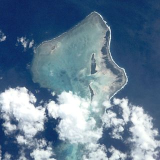
Rowa Islands are an uninhabited archipelago in Torba Province of Vanuatu in the Pacific Ocean. The Rowa are a part of larger Banks Islands archipelago. The islands are a natural border between Melanesia and Polynesia; they are one of the most beautiful places in the South Pacific Ocean and an integral part of a vast system of atolls and reefs.

The Narave or Naravé pig is a type of domestic pig native to northern Vanuatu. Narave pigs are pseudohermaphrodite (intersex) male individuals that are kept for ceremonial purposes.

References

13°50′S167°35′E / 13.833°S 167.583°E / -13.833; 167.583