Mount Baker, also known as Koma Kulshan or simply Kulshan, is a 10,781 ft (3,286 m) active glacier-covered andesitic stratovolcano in the Cascade Volcanic Arc and the North Cascades of Washington State in the United States. Mount Baker has the second-most thermally active crater in the Cascade Range after Mount St. Helens. About 30 miles (48 km) due east of the city of Bellingham, Whatcom County, Mount Baker is the youngest volcano in the Mount Baker volcanic field. While volcanism has persisted here for some 1.5 million years, the current volcanic cone is likely no more than 140,000 years old, and possibly no older than 80–90,000 years. Older volcanic edifices have mostly eroded away due to glaciation.

Mount Taranaki is a dormant stratovolcano and legal person in the Taranaki region on the west coast of New Zealand's North Island. At 2,518 metres (8,261 ft), it is the second highest mountain in the North Island, after Mount Ruapehu. It has a secondary cone, Fanthams Peak, 1,966 metres (6,450 ft), on its south side.

Mount Pinatubo is an active stratovolcano in the Zambales Mountains in Luzon in the Philippines. Located on the tripoint of Zambales, Tarlac and Pampanga provinces, most people were unaware of its eruptive history before the pre-eruption volcanic activity in early 1991. Dense forests, which supported a population of several thousand indigenous Aetas, heavily eroded and obscured Pinatubo.

Mount Aso or Aso Volcano is the largest active volcano in Japan and among the largest in the world. Common use relates often only to the somma volcano in the centre of Aso Caldera. It stands in Aso Kujū National Park in Kumamoto Prefecture, on the island of Kyushu. Its tallest peak, Takadake, is 1,592 meters (5,223 ft) above sea level. Mount Aso is in a fairly large caldera with a circumference of around 120 km (75 mi), although sources vary on the exact distance. It is one of the 100 Famous Japanese Mountains.

Mount Agung is an active volcano in Karangasem Regency, Bali, Indonesia. It is located southeast of Mount Batur volcano, also in Bali. It is the highest point on Bali, and dominates the surrounding area, influencing the climate, especially rainfall patterns. From a distance, the mountain appears to be perfectly conical. From the peak of the mountain, it is possible to see the peak of Mount Rinjani on the nearby island of Lombok, to the east, although both mountains are frequently covered in clouds. Agung is a stratovolcano, with a large and deep crater. Its most recent eruptions occurred from 2017–2019.

Mount Cleveland is a nearly symmetrical stratovolcano on the western end of Chuginadak Island, which is part of the Islands of Four Mountains just west of Umnak Island in the Fox Islands of the Aleutian Islands of Alaska. Mount Cleveland is 5,675 ft (1,730 m) high, and one of the most active of the 75 or more volcanoes in the larger Aleutian Arc. Aleutian natives named the island after their fire goddess, Chuginadak, who they believed inhabited the volcano. In 1894 a team from the United States Coast and Geodetic Survey visited the island and gave Mount Cleveland its current name, after then-president Grover Cleveland.

A volcanic plug, also called a volcanic neck or lava neck, is a volcanic object created when magma hardens within a vent on an active volcano. When present, a plug can cause an extreme build-up of high gas pressure if rising volatile-charged magma is trapped beneath it, and this can sometimes lead to an explosive eruption. In a plinian eruption the plug is destroyed and ash is ejected.
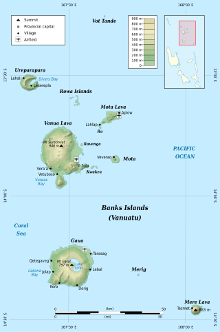
The Banks Islands are a group of islands in northern Vanuatu. Together with the Torres Islands to their northwest, they make up the northernmost province of Torba. The island group lies about 40 km (25 mi) north of Maewo, and includes Gaua and Vanua Lava, two of the 13 largest islands in Vanuatu. In 2009, the islands had a population of 8,533. The island group's combined land area is 780 km2 (300 sq mi).

Semisopochnoi Island or Unyak Island is part of the Rat Islands group in the western Aleutian Islands of Alaska. The island is uninhabited and provides an important nesting area for maritime birds. The island is of volcanic origin, containing several volcanoes including Mount Young. It has a land area of 85.558 square miles, measuring 11 miles (18 km) in length and 12 miles (20 km) in width.

A somma volcano, also known as a sommian, is a volcanic caldera that has been partially filled by a new central cone. The type is named after Mount Somma ("Summit"), a stratovolcano in southern Italy with a summit caldera in which the upper cone of Mount Vesuvius has grown. Other examples of somma volcanoes can be found on Russia's Kamchatka Peninsula and the Kuril Islands, stretching south from Kamchatka to Hokkaidō, Japan.

Mount Chōkai is an active volcano located on the border of Akita and Yamagata in the Tōhoku region of Japan, and is 2,236 m (7,336 ft) tall. Because of its (roughly) symmetrical shape and massive size, it is also variously known as Dewa Fuji (出羽富士), Akita Fuji (秋田富士) or Shōnai Fuji (庄内富士) depending on the location of the viewer. In addition to being one of the 100 Famous Landscapes of Japan, it is also included as one of the 100 famous mountains in Japan, and famous 100 Geographical Features of Japan. It is surrounded by Chōkai Quasi-National Park. It is also a National Historic Site of Japan, and is regarded as a sacred mountain by followers of the Shugendō branch of Shinto which has the shrine Chōkaisan Ōmonoimi Shrine there and is popular with hikers.

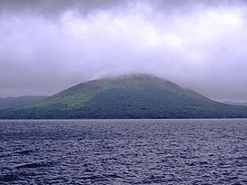
Gaua is the largest and second most populous of the Banks Islands in Torba Province in northern Vanuatu. It covers 342 km2.

Mount Hibok-Hibok is a stratovolcano on Camiguin Island in the Philippines. One of the active volcanoes in the country, it is part of the Pacific ring of fire.

The Mount Meager massif is a group of volcanic peaks in the Pacific Ranges of the Coast Mountains in southwestern British Columbia, Canada. Part of the Cascade Volcanic Arc of western North America, it is located 150 km (93 mi) north of Vancouver at the northern end of the Pemberton Valley and reaches a maximum elevation of 2,680 m (8,790 ft). The massif is capped by several eroded volcanic edifices, including lava domes, volcanic plugs and overlapping piles of lava flows; these form at least six major summits including Mount Meager which is the second highest of the massif.

Mount Fuji is a dormant volcano which is the tallest peak in Japan. The latest eruption of Mount Fuji was triggered by an earthquake in 1707. The mountain as it appears now is known as the "New Fuji volcano", which began to erupt about 10,000 years ago. Under the "New Fuji volcano" lies the "Old Fuji volcano", which was active between 100,000 years ago and 10,000 years ago, and the "Komitake volcano", which became active 700,000 years ago.

Mount Nikkō-Shirane is a stratovolcano in the Nikkō National Park in central Honshū, the main island of Japan. It stands at 2,578 m high. It is the highest mountain in north eastern Japan. Its peak is a Lava dome of andesite. Mt Nikkō-Shirane is listed in the 100 famous mountains in Japan proposed by Kyuya Fukada and also of one of the famous mountains of Tochigi and Gunma prefectures respectively.

The Cascade Volcanoes are a number of volcanoes in a volcanic arc in western North America, extending from southwestern British Columbia through Washington and Oregon to Northern California, a distance of well over 700 miles (1,100 km). The arc formed due to subduction along the Cascadia subduction zone. Although taking its name from the Cascade Range, this term is a geologic grouping rather than a geographic one, and the Cascade Volcanoes extend north into the Coast Mountains, past the Fraser River which is the northward limit of the Cascade Range proper.

Several types of volcanic eruptions—during which material is expelled from a volcanic vent or fissure—have been distinguished by volcanologists. These are often named after famous volcanoes where that type of behavior has been observed. Some volcanoes may exhibit only one characteristic type of eruption during a period of activity, while others may display an entire sequence of types all in one eruptive series.

Lake Letas is the largest lake in Vanuatu, located in the center of the volcanic island of Gaua of the Banks Islands in northern Vanuatu. The place submitted an application to be considered an UNESCO World Heritage Site in 2004, and has been listed as a protected Ramsar site since 2023.
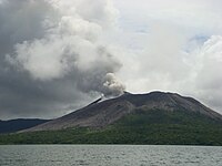 Eruption of Mt Garet in Sept 2010.
 2013 satellite picture of Mt Garet during eruption