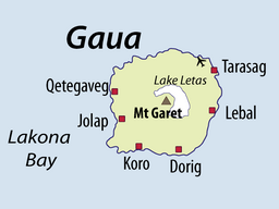
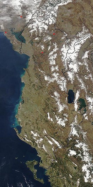
Lake Letas is the largest lake in Vanuatu, located in the center of the volcanic island of Gaua of the Banks Islands in northern Vanuatu. The place submitted an application to be considered an UNESCO World Heritage Site in 2004, and has been listed as a protected Ramsar site since 2023.[3]
The volcanic lake is U-shaped, surrounding Mount Gharat on all sides except southwest. It is about 9km long (north to south) and about 6km wide, with an area of 19km2. It is situated in the center of the 20km diameter island; the lake rests 418 meters above sea level[2] and it is 119 meters deep.[1] It is a fresh water lake with a temperature of 32°C, where only eels and shrimps can survive.[4] The water in the lake is not very clear, but has a greenish color. Water constantly flows out of the lake at a natural overflow located on the eastern side of the lake. The water flows about 3km east to Siri Waterfall and then another 3km through rivers Namang or Be Solomul before it reaches the sea.
2013 Satellite view of Gaua I., with Lake Letas and Mt Gharat in its center
Local people say there is a canoe at the top of the lake which is used to cross the lake from the eastern side to get to Mount Gharat. The canoe is sometimes located on the eastern edge of the lake (near the water overflow), or sometimes on the north-eastern edge of the lake (nearest Gaua Airport).
A rough estimate of the water flow rate out of the lake (during the dry season month of August 2006) was approximately 3 cubic meters per second.
In the 1980s it was suggested that the lake could be used as a resource for power generation to supply industrial developments but later the Tourism Council of the South Pacific has suggested that the lake should be included in Vanuatu's protected area system. The Department of Physical Planning and Environment is currently considering the status of protected area to the lake.
1 2 Bani, Ernest, & David Esrom. 1993. Republic of VanuatuArchived 2010-07-17 at the Wayback Machine . In A directory of wetlands in Oceania, ed. by D. A. Scott. Slimbridge, UK: International Waterfowl and Wetlands Research Bureau, 397-420.
Lake Saint Pierre is a lake in Quebec, Canada, a widening of the Saint Lawrence River between Sorel-Tracy and Trois-Rivières. It is located downstream, and northeast, of Montreal; and upstream, and southwest, of Quebec City. The end of the lake delimits the beginning of the estuary of Saint Lawrence.
A transboundary protected area (TBPA) is an ecological protected area that spans boundaries of more than one country or sub-national entity. Such areas are also known as transfrontier conservation areas (TFCAs) or peace parks.
Mývatn is a shallow lake situated in an area of active volcanism in the north of Iceland, near Krafla volcano. It has a high amount of biological activity. The lake and the surrounding wetlands provides a habitat for a number of waterbirds, especially ducks. The lake was created by a large basaltic lava eruption 2300 years ago, and the surrounding landscape is dominated by volcanic landforms, including lava pillars and rootless vents (pseudocraters). The effluent river Laxá is known for its rich fishing for brown trout and Atlantic salmon.
Lake Ohrid is a lake which straddles the mountainous border between the southwestern part of North Macedonia and eastern Albania. It is one of Europe's deepest and oldest lakes, with a unique aquatic ecosystem of worldwide importance, with more than 200 endemic species.
Vembanad is the longest lake in India, as well as the largest in the state of Kerala. The lake has an area of 230 square kilometers and a maximum length of 89.5 km.
Ashtamudi Lake, in the Kollam District of the Indian state of Kerala is a unique wetland ecosystem and a large palm-shaped water body. It is second only in size to the Vembanad estuary ecosystem of the state. Ashtamudi means 'eight hills or peaks' in the local Malayalam language. The name is indicative of the lake's topography with its multiple branches. The lake is also called the gateway to the backwaters of Kerala and is well known for its houseboat and backwater resorts. Ashtamudi Wetland was included in the list of wetlands of international importance, as defined by the Ramsar Convention for the conservation and sustainable utilization of wetlands. Ashtamudi Estuary is the deepest among all the estuaries in Kerala, with a maximum depth of 6.4 meters at the confluence zone.
Lake Corangamite, a hypersaline endorheic lake, is located near Colac in the Lakes and Craters region of the Victorian Volcanic Plains of south-west Victoria, Australia. The lake's salinity levels have increased dramatically as the lake level has dropped in recent decades. It is Australia's largest permanent saline lake, covering approximately 230 square kilometres (89 sq mi) with a circumference of 150 kilometres (93 mi). It forms part of the Ramsar-listed Western District Lakes wetland site. The Aboriginal name of the lake is recorded as Kronimite.
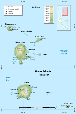
The Banks Islands are a group of islands in northern Vanuatu. Together with the Torres Islands to their northwest, they make up the northernmost province of Torba. The island group lies about 40 km (25 mi) north of Maewo, and includes Gaua and Vanua Lava, two of the 13 largest islands in Vanuatu. In 2009, the islands had a population of 8,533. The island group's combined land area is 780 km2 (300 sq mi).
Uvs Lake is a highly saline lake in an endorheic basin—Uvs Nuur Basin, primarily in Mongolia with a smaller part in Russia. It is the largest lake in Mongolia by surface area, covering 3,350 km2 at 759 m above sea level. The northeastern tip of the lake is situated in the Tuva Republic of the Russian Federation. The largest settlement near the lake is Ulaangom. This shallow and very saline body of water is a remainder of a huge saline sea which covered a much larger area several thousand years ago.
Butrint National Park is a national park in Vlorë County, southern Albania. It is located 18 kilometres (11 mi) south of Sarandë. The park encompasses 9,424 hectares (94.24 km2) of hilly terrain with freshwater lakes, wetlands, salt marshes, open plains, reed beds and islands. The park's significance for conservation is reflected in the large number of species with over 1,200 different animals and plants. Its mandate includes the protection of the lake and lagoon of Butrint, the natural channel of Vivari, the islands of Ksamil and as well the archaeological site, that provides valuable remains of ancient civilisations.
Gaua is the largest and second most populous of the Banks Islands in Torba Province in northern Vanuatu. It covers 342 km2.
Siri Waterfall, formerly called Santa Maria Waterfall, is a 120-metre-high (390 ft) waterfall located about 3 km inland from the eastern coast of the island of Gaua in northern Vanuatu.
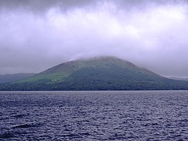
Mount Gharat or Mount Garet, a somma volcano, is the highest peak on the volcanic island of Gaua of the Banks Islands in northern Vanuatu.
Kolkheti National Park, is a national park located in Samegrelo-Zemo Svaneti and Guria in the historical region of Colchis in western Georgia. The wetlands of Central Kolkheti are a Wetland of International Importance, a Ramsar Site. It lies on a coastal plain on the Black Sea, between the mouths of the Tikori and Supsa and spanning the districts of Zugdidi, Khobi, Lanchkhuti, Senaki and Abasha. The park was established during 1998 and 1999 as part of Georgia's Integrated Coastal Management Project, which was backed financially by the World Bank (WB) and the Global Environmental Facility (GEF). Kolkheti National Park covers an area of 28,940 hectares and with protected wetlands protected area spans to 33710 hectares, incorporating the land of the former 500-hectare Kolkheti State Nature Reserve, which had been established in 1947, and its surrounding wetlands, including the lake Paliastomi. Because of its unique forests and wetlands, and high numbers of threatened species, the park was inscribed on the UNESCO World Heritage List as part of the Colchic Rainforests and Wetlands site in 2021.
Škocjan Caves is a cave system located in Slovenia. Škocjan Caves was included on UNESCO’s list of natural and cultural World Heritage Sites in 1986. Škocjan Caves is a significant underground phenomenon on the Karst Plateau and in Slovenia. After gaining independence from Yugoslavia in 1991, Slovenia made a commitment to actively protect the Škocjan Caves area. To fulfill this commitment, Škocjan Caves Regional Park was established, along with its managing authority, the Škocjan Caves Park Public Service Agency.
The Central Mountain Region is a physiogeographical region encompassing the central and eastern edge of Albania. It comprises the mountainous inland extending all the way from the valley of Drin and the mountains of Sharr, Skanderbeg, Korab, and Shebenik-Jabllanicë, through the lakes of Ohrid and Prespa, until it reaches the village of Ersekë and the mountains of Pindus close to the border between the country and Greece.
Lake Pinaroo lies in the north west corner of Sturt National Park, a protected national park in the Far West region of New South Wales, Australia. The location covers an area of 718.8 ha, approximately 80 km north-west of Tibooburra and 24 km south-east of Cameron Corner. Grid coordinates 29°06’S, 141°13’E. On 19 March 1996 the lake was recognised as a wetland of international importance by designation (RS799) under the Ramsar Convention.
The Central Mexican wetlands is a flooded grasslands and savannas ecoregion in central Mexico.
Nahá–Metzabok Biosphere Reserve is a biosphere reserve in southeastern Mexico. It is located in the state of Chiapas, on the northeastern flank of the Chiapas Highlands. The reserve protects montane rain forests, pine and oak forests, and natural lakes.
Korgalzhyn is a lake in Korgalzhyn District, Akmola Region, Kazakhstan. Korgalzhyn is the main body of water of the Korgalzhyn group of lakes, which includes Birtaban, Sholakshalkar, Shalkar, Zhanybekshalkar, Uialyshalkar and Zhandyshalkar.
This page is based on this Wikipedia article Text is available under the CC BY-SA 4.0 license; additional terms may apply. Images, videos and audio are available under their respective licenses.