The Federated States of Micronesia, or simply Micronesia, is an island country in Micronesia, a subregion of Oceania. The federation consists of four states—from west to east: Yap, Chuuk, Pohnpei, and Kosrae—that span across the western Pacific just north of the equator, for a longitudinal distance of almost 2,700 km (1,700 mi). Together, the states comprise around 607 islands and a combined land area of approximately 702 km2 or 271 sq mi.

The Federated States of Micronesia are located on the Caroline Islands in the western Pacific Ocean. The history of the modern Federated States of Micronesia is one of settlement by Micronesians; colonization by Spain, Germany, and Japan; United Nations trusteeship under United States-administered Trust Territory of the Pacific Islands; and gradual independence beginning with the ratification of a sovereign constitution in 1979.
Geography of the Federated States of Micronesia (FSM), a country located in the western Pacific Ocean, and in the Micronesia cultural and ecological sub-region of Oceania. While its total land area is very small at 702 km2 (271 sq mi), it has the 14th largest exclusive economic zone at 2,996,419 km2 (1,156,924 sq mi).

Micronesia is a subregion of Oceania, consisting of approximately 2,000 small islands in the Northwestern Pacific Ocean. It has a close shared cultural history with three other island regions: Maritime Southeast Asia to the west, Polynesia to the east, and Melanesia to the south—as well as with the wider community of Austronesian peoples.

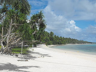
Pohnpei is an island of the Senyavin Islands which are part of the larger Caroline Islands group. It belongs to Pohnpei State, one of the four states in the Federated States of Micronesia (FSM). Major population centers on Pohnpei include Palikir, the FSM's capital, and Kolonia, the capital of Pohnpei State. Pohnpei is the largest island in the FSM, with an area of 334 km2 (129 sq mi), and a highest point of 782 m (2,566 ft), the most populous with 36,832 people, and the most developed single island in the FSM.
Majuro is the capital and largest city of the Marshall Islands. It is also a large coral atoll of 64 islands in the Pacific Ocean. It forms a legislative district of the Ratak (Sunrise) Chain of the Marshall Islands. The atoll has a land area of 9.7 square kilometers (3.7 sq mi) and encloses a lagoon of 295 square kilometers (114 sq mi). As with other atolls in the Marshall Islands, Majuro consists of narrow land masses. It has a tropical trade wind climate, with an average temperature of 27 °C (81 °F).
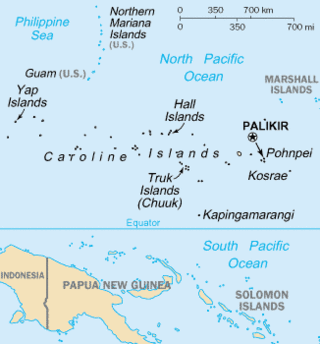
The Caroline Islands are a widely scattered archipelago of tiny islands in the western Pacific Ocean, to the north of New Guinea. Politically, they are divided between the Federated States of Micronesia (FSM) in the central and eastern parts of the group, and Palau at the extreme western end. Historically, this area was also called Nuevas Filipinas or New Philippines, because they were part of the Spanish East Indies and were governed from Manila in the Philippines.

Woleai, also known as Oleai, is a coral atoll of 22 islands in the western Caroline Islands in the Pacific Ocean, forming a legislative district in the Yap State in the Federated States of Micronesia, and located approximately 57 kilometers west-northwest of Ifalik and 108 kilometers northeast of Eauripik. Woleai is also the name of the largest of the islets constituting the atoll, lying to the northeast.

Polynesian outliers are a number of culturally Polynesian societies that geographically lie outside the main region of Polynesian influence, known as the Polynesian Triangle; instead, Polynesian outliers are scattered in the two other Pacific subregions, Melanesia and Micronesia. Based on archaeological and linguistic analysis, these islands are considered to have been colonized by seafaring Polynesians, mostly from the area of Tonga, Samoa and Tuvalu.
Kapingamarangi is an atoll and a municipality in the state of Pohnpei of the Federated States of Micronesia. It is by far the most southerly atoll or island of the country and the Caroline Islands, 300 km (190 mi) south of the next southerly atoll, Nukuoro, and 740 km (460 mi) southwest of the main island of Pohnpei state; it forms a Polynesian outlier.

Nukuoro is an atoll in the Federated States of Micronesia. It is a municipality of the state of Pohnpei, Federated States of Micronesia. It is the secondmost southern atoll of the country, after Kapingamarangi. They both are Polynesian outliers. As of 2007, Nukuoro had a population of 372, though several hundred Nukuorans live on Pohnpei. Fishing, animal husbandry, and agriculture are the main occupations. A recent project to farm black pearl oysters has been successful at generating additional income for the island's people.

Pohnpei State is one of the four states of the Federated States of Micronesia (FSM). Its capital is Kolonia. With an area of 346 miles, it is the largest state.

The Senyavin Islands belong to Pohnpei State in the Federated States of Micronesia. They consist of a larger volcanic Pohnpei Island and two small atolls Ant and Pakin.
The Nukuoro language is a Polynesian Outlier language, spoken by about 1,200 people on Nukuoro Atoll and on Pohnpei, two islands of Pohnpei State within the Federated States of Micronesia. Nukuoro is a remote coral atoll with a population of about 150, where the primary language is Nukuoro. An additional several hundred Nukuoro speakers live in Kolonia, Pohnpei, with smaller diaspora communities elsewhere in Micronesia and in the United States. Most Nukuoro speakers, particularly those that live away from Nukuoro Atoll, are multilingual in Pohnpeian and/or English; some older Nukuoro speakers also know German or Japanese.
Micronesian mythology comprises the traditional belief systems of the people of Micronesia. There is no single belief system in the islands of Micronesia, as each island region has its own mythological beings.
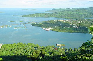
Kolonia is a coastal town and the capital of Pohnpei State in the Federated States of Micronesia (FSM). It's not to be confused with the far smaller Colonia, the capital of the State of Yap. It was also the former FSM capital before being replaced by Palikir in 1989, located nearby to the southwest in the municipality of Sokehs. It has 6,074 people.

Pakin Atoll is a small atoll lying off the northwest coast of Pohnpei in the Federated States of Micronesia. Along with the nearby Ant Atoll these islands constitute the Senyavin group of islands.

Sapwuahfik, formerly Ngatik, or the Raven Islands is a 110-square-kilometer (42 sq mi) atoll in Pohnpei state of the Federated States of Micronesia. It is a village and municipality of roughly 430 people on a land area of 1.5 square kilometers (0.58 sq mi).
The nationality law of the Federated States of Micronesia determines who is or may become a citizen or national of the Federated States of Micronesia (FSM). Article III of the Constitution of the Federated States of Micronesia provides the basis for nationality law, while specific provisions are elaborated in 7 FSMC § 201 et seq.
