List of islands of Papua New Guinea

Last updated

Map of Papua New Guinea Papua Neuguinea.jpg
Map of Papua New Guinea

This is a list of islands in Papua New Guinea , as to most of its 600 main islands, by province listed NW to SE. [1]

Contents

Numbered provinces in Papua New Guinea, referred to in the text Papua new guinea provinces (numbers) 2012.png
Numbered provinces in Papua New Guinea, referred to in the text

Sandaun Province

(No. 19 on the map)

East Sepik Province

(No. 5 on the map)

Manus Province

(No. 9 on the map)

The Admiralty Islands Admiralty Islands Topography with labels.png
The Admiralty Islands

New Ireland Province

(No. 12 on the map)

New Ireland Province NewIrelandOMC.png
New Ireland Province

West New Britain Province

(No. 18 on the map)

New Britain NewBritainOMC.png
New Britain

East New Britain Province

(No. 4 on the map)

Madang Province

(No 8 on the map)

Morobe Province

(No. 11 on the map)

Autonomous Region of Bougainville

(No. 14 on map)

Bougainville BougainvilleBukaandNeighbourhood.png
Bougainville

Western Province

(No. 16 on map)

The islands of the Fly River Delta, including Kiwai, Purutu and Wabuda Kiwai-143.41667E 8.55000S.png
The islands of the Fly River Delta, including Kiwai, Purutu and Wabuda

Gulf Province

(No. 7 on map)

National Capital District
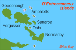
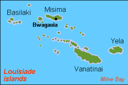
(No. 20 on map)

• Loloata Islands

Milne Bay Province

(No. 10 on the map)

Trobriand Islands Karta PG Trobriand isl.PNG
Trobriand Islands
D'Entrecasteaux Islands Karta PG D'Entrecasteaux isl.PNG
D'Entrecasteaux Islands
Woodlark Islands Karta PG Woodlark isl.png
Woodlark Islands
Louisiade Archipelago Karta PG Louisiade isl.PNG
Louisiade Archipelago

References

  1. "Papua New Guinea". The Commonwealth. Retrieved 17 May 2019.