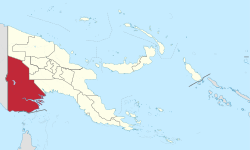
Sandaun Province is the northwesternmost mainland province of Papua New Guinea. It covers an area of 35,920 km2 and has a population of 248,411. The capital is Vanimo. In July 1998 the area surrounding the town of Aitape was hit by an enormous tsunami caused by a Magnitude 7.0 earthquake which killed over 2,000 people. The five villages along the west coast of Vanimo towards the International Border are namely; Lido, Waromo, Yako, Musu and Wutung. It borders Indonesia.
Madang is a province of Papua New Guinea. The province is on the northern coast of mainland Papua New Guinea and has many of the country's highest peaks, active volcanoes and its biggest mix of languages. The capital is the town of Madang.

The Ok Tedi is a river in New Guinea. The Ok Tedi Mine is located near the headwaters of the river, which is sourced in the Star Mountains. It is the second largest tributary of the Fly River. Nearly the entirety of the river runs through the North Fly District of the Western Province of Papua New Guinea, but the river crosses the international boundary with Indonesia for less than one kilometre. The largest settlement of the Western Province, Tabubil is located near its banks.
East New Britain is a province of Papua New Guinea, consisting of the north-eastern part of the island of New Britain and the Duke of York Islands. The capital of the province is Kokopo, not far from the old capital of Rabaul, which was largely destroyed in a volcanic eruption in 1994. East New Britain covers a total land area of 15,816 square kilometres (6,107 sq mi), and the province's population was reported as 220,133 in the 2000 census, rising to 328,369 in the 2011 count. Provincial coastal waters extend over an area of 104,000 square metres. The province's only land border is with West New Britain Province to the west, and it also shares a maritime border with New Ireland Province to the east.

Chimbu, more frequently spelled Simbu, is a province in the Highlands Region of Papua New Guinea. The province has an area of 6,112 km2 and a population of 376,473. The capital of the province is Kundiawa. Mount Wilhelm, the tallest mountain in Papua New Guinea is on the border of Eastern part of Simbu and the Western part of Madang Province.

Gulf Province is a province of Papua New Guinea located on the southern coast. The provincial capital is Kerema. The 34,472 km2 province is dominated by mountains, lowland river deltas, and grassland flood plains. In Gulf Province, the Kikori, Turama, Purari, and Vailala rivers meet the Papuan Gulf. The province has the second-smallest population of all the provinces of Papua New Guinea with 106,898 inhabitants. The province shares land borders with Western Province to the west, Southern Highlands, Chimbu, and Eastern Highlands to the north, Morobe Province to the east, and Central Province to the southeast.
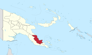
Oro Province, formerly Northern Province, is a coastal province in the Southern Region of Papua New Guinea. The provincial capital is Popondetta. The province covers 22,800 km2, and has 176,206 inhabitants. The province shares land borders with Morobe Province to the northwest, Central Province to the west and south, and Milne Bay Province to the southeast. The province is located within the Papuan Peninsula.

West New Britain is a province of Papua New Guinea on the islands of New Britain. The provincial capital is Kimbe. The area of the province is 20,387 km2 with a population of 264,264 as of the 2011 census. The province's only land border is with East New Britain. There are seven major tribes, the Nakanai, Bakovi, Kove, Unea, Maleu, Arowe, speaking about 25 languages.

Western Highlands is a province of Papua New Guinea. The provincial capital is Mount Hagen. The province covers an area of 4,299 km2, and there are 362,850 inhabitants, making the Western Highlands the most densely populated province. Tea and coffee are grown in the Western Highlands.

Eastern Highlands is a highlands province of Papua New Guinea. The provincial capital is Goroka. The province covers an area of 11,157 km2, and has a population of 579,825. The province shares a common administrative boundary with Madang Province to the north, Morobe Province to the east, Gulf Province to the south, and Simbu Province to the west. The province is the home of the Asaro mud mask that is displayed at shows and festivals within the province and in the country. The province is reachable by air, including Goroka Airport, and road transport, including the main Highlands Highway.

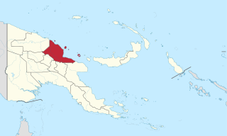
East Sepik is a province in Papua New Guinea. Its capital is Wewak. East Sepik has an estimated population of 433,481 people and is 43,426 km square in size.

Central Province is a province in Papua New Guinea located on the southern coast of the country. It has a population of 237,016 people and is 29,998 square kilometres (11,582 sq mi) in size. The seat of government of Central Province, which is located within the National Capital District outside the province, is the Port Moresby suburb of Konedobu. On 9 October 2007, the Central Province government announced plans to build a new provincial capital city at Bautama, which lies within Central Province near Port Moresby, although there has been little progress in constructing it.
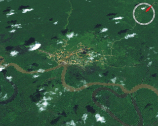
Tabubil is a town located in the Star Mountains area of the North Fly District of Western Province, Papua New Guinea. The town, including the adjoining relocated village of Wangabin and the industrial area of Laydown, is the largest settlement in the province, although the provincial capital, Daru is a similar size. It had a recorded population of 10,270 at the 2011 census.

Manus Province is the smallest province in Papua New Guinea in terms of both land area and population, with a land area of 2,100 square kilometres (810 sq mi), but with more than 220,000 square kilometres (85,000 sq mi) of water, and the total population is 60,485. The provincial town of Manus is Lorengau.

The Ok Tedi Mine is an open-pit copper and gold mine in Papua New Guinea located near the headwaters of the Ok Tedi River, in the Star Mountains Rural LLG of the North Fly District of the Western Province of Papua New Guinea.
Kiunga is a port town on the Fly River in the Western Province of Papua New Guinea, just upstream from the D'Albertis Junction with the Ok Tedi River. It is the southernmost terminus of the Kiunga-Tabubil Highway. Local industry rests on a cornerstone of freight and haulage, particularly from the Ok Tedi Mine and provisioning for the much larger town of Tabubil. Natural rubber has been an emerging industry more recently, with a processing/manufacturing plant being built in town.

The Kiunga-Tabubil Highway is an all-weather gravel road that runs from the river port town of Kiunga through Ningerum and Tabubil to the Ok Tedi Mine site, in the remote North Fly District of the Western Province of Papua New Guinea. The road is around 137 kilometres (85 mi) long, but this changes as sections are rehashed.

The North Fly District of the Western Province of Papua New Guinea is the northernmost, smallest, and arguably the most remote of the three districts of the province. It contains the Local-Level Government (LLG) areas of Kiunga Rural, Kiunga Urban, Ningerum Rural, Olsobip Rural and Star Mountains Rural, and the townships of Kiunga, Tabubil, Olsobip and Ningerum.
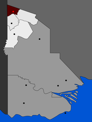
Star Mountains Rural LLG is a local-level government situated in the Star Mountains in North Fly District of Western Province of Papua New Guinea. In the year 2000, the LLG had 1691 homes, and a population of 12,114 people. The current population is more likely to now be around 15,000 people. The main population centre in the LLG is Tabubil. Finalbin and the Ok Tedi Mine are also in this LLG.

The Middle Fly District of the Western Province of Papua New Guinea is a large, coastal district that forms the central area of the Fly River basin. It contains the Local-Level Government areas of: Balimo Urban, Bamu Rural, Gogodaia Rural, Lake Murray Rural, and Nomad Rural, and the population centres of Balimo, Bamu, Gogodala and Nomad. It also contains the largest lake in the country, Lake Murray.