
The Fly River is the third longest river in the island of New Guinea, after the Sepik River and Mamberamo River with a total length of 1,060 km (660 mi) and the largest by volume of discharge in Oceania, the largest in the world without a single dam in its catchment, and overall the 20th-largest primary river in the world by discharge volume. It is located in the southwest of Papua New Guinea and Papua Province of Indonesia. It rises in the Victor Emanuel Range arm of the Star Mountains, and crosses the south-western lowlands before flowing into the Gulf of Papua in a large delta. The Fly-Strickland River system has a total length of 1,220 km (760 mi) making it the longest river system of an island in the world, including 824 km (512 mi) Strickland River is the longest and largest tributary of Fly River, making it the farthest distance source of the Fly River.

The Ok Tedi is a river in New Guinea. The Ok Tedi Mine is located near the headwaters of the river, which is sourced in the Star Mountains. It is the second largest tributary of the Fly River. Nearly the entirety of the river runs through the North Fly District of the Western Province of Papua New Guinea, but the river crosses the international boundary with Indonesia for less than one kilometre. The largest settlement of the Western Province, Tabubil is located near its banks.

Gulf Province is a province of Papua New Guinea located on the southern coast. The provincial capital is Kerema. The 34,472 km² province is dominated by mountains, lowland river deltas, and grassland flood plains. In Gulf Province, the Kikori, Turama, Purari, and Vailala rivers meet the Papuan Gulf. The province has the second-smallest population of all the provinces of Papua New Guinea with 106,898 inhabitants. The province shares land borders with Western Province to the west, Southern Highlands, Chimbu, and Eastern Highlands to the north, Morobe Province to the east, and Central Province to the southeast.

Western Province is a coastal province in southwestern Papua New Guinea, bordering the Indonesian province of Papua. The provincial capital is Daru. The largest town in the province is Tabubil. Other major settlements are Kiunga, Ningerum, Olsobip and Balimo.

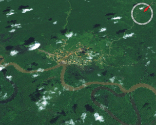
Tabubil is a town located in the Star Mountains area of the North Fly District of Western Province, Papua New Guinea. The town, including the adjoining relocated village of Wangabin and the industrial area of Laydown, is the largest settlement in the province, although the provincial capital, Daru is a similar size. It had a recorded population of 10,270 at the 2011 census.
Gogodala is the name of an ethnic/language group from the Middle Fly District of the Western Province of Papua New Guinea. They speak the Gogodala language, which belongs to the Trans-New Guinea language family. It is one of about a thousand distinct ethnic groups in the country, each which has its own language and culture.

The Ok Tedi Mine is an open-pit copper and gold mine in Papua New Guinea located near the headwaters of the Ok Tedi River, in the Star Mountains Rural LLG of the North Fly District of the Western Province of Papua New Guinea.
Kiunga is a port town on the Fly River in the Western Province of Papua New Guinea, just upstream from the D'Albertis Junction with the Ok Tedi River. It is the southernmost terminus of the Kiunga-Tabubil Highway. Local industry rests on a cornerstone of freight and haulage, particularly from the Ok Tedi Mine and provisioning for the much larger town of Tabubil. Natural rubber has been an emerging industry more recently, with a processing/manufacturing plant being built in town.
The Ok Tedi environmental disaster caused severe harm to the environment along 1,000 km (620 mi) of the Ok Tedi River and the Fly River in the Western Province of Papua New Guinea between around 1984 and 2013. The lives of 50,000 people have been disrupted. One of the worst environmental disasters caused by humans, it is a consequence of the discharge of about two billion tons of untreated mining waste into the Ok Tedi from the Ok Tedi Mine, an open pit mine situated in the province.

The North Fly District of the Western Province of Papua New Guinea is the northernmost, smallest, and arguably the most remote of the three districts of the province. It contains the Local-Level Government (LLG) areas of Kiunga Rural, Kiunga Urban, Ningerum Rural, Olsobip Rural and Star Mountains Rural, and the townships of Kiunga, Tabubil, Olsobip and Ningerum.

Star Mountains Rural LLG is a local-level government situated in the Star Mountains in North Fly District of Western Province of Papua New Guinea. In the year 2000, the LLG had 1691 homes, and a population of 12,114 people. The current population is more likely to now be around 15,000 people. The main population centre in the LLG is Tabubil. Finalbin and the Ok Tedi Mine are also in this LLG.

Olsobip is a station town in the north of the Papua New Guinean Western province, located on the Upper Fly River. It is the seat of the Olsobip Rural LLG. It has a rural airport (OLQ) but, set in a rich forest, it is inaccessible by road. As a result of its isolation, accurate census data is difficult to obtain from Olsobip.

This page is a list of districts of Papua New Guinea.
The Birim River or Ok Birim in the western province of New Guinea is a tributary of the Ok Tedi River, which is in turn a tributary of the north Fly River. The Birim river joins the Ok Tedi river from the west between Ningerum and Bige. The Birim river area is inhabited by the Yonggom tribe. They practise tropical forest Swidden agriculture. About 3,000 people, they speak the Ninggerum language of the Ok group.
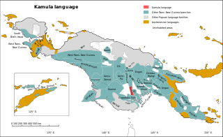
Kamula is a Trans–New Guinea language that is unclassified within that family in the classification of Malcolm Ross (2005). Noting insufficient evidence, Pawley and Hammarström (2018) leave it as unclassified.

Tabo, also known as Waia (Waya), is a Papuan language of Western Province, Papua New Guinea, just north of the Fly River delta. The language has also been known as Hiwi and Hibaradai.
The Waruna language is a Papuan language of the New Guinea, spoken in a bend of the Fly River. It has 50% lexical similarity with Ari, its closest relative. It is spoken in the single village of Waruna in Gogodala Rural LLG.
Foia Foia (Foyafoya), or Minanibai, is a Papuan language of Papua New Guinea, spoken in an area near Omati River mouth in Ikobi Kairi and Goaribari Census districts.
Roy Biyama Papua New Guinean politician. He has been a member of the National Parliament of Papua New Guinea since 2002, representing the electorate of Middle Fly Open, and has been a member of four parties: the Papua New Guinea Revival Party, the People's Action Party, the United Resources Party and the People's National Congress. He served as Minister for Higher Education, Research, Science and Technology (2003-2004), Minister for Labour and Industrial Relations (2004-2006) and Minister Assisting the Prime Minister (2006-2007) in the Somare government. He has also been Governor of Western Province since February 2017.

Bamu Rural LLG is a local-level government (LLG) of Western Province, Papua New Guinea. The Kamula language is spoken in the LLG, near the Wawoi Falls area.

