North Fly District

Last updated
North Fly District
Loc-nthfly.svg
Papua New Guinea location map.svg
Red pog.svg
North Fly District
Location within Papua New Guinea
Coordinates: 6°7′S141°18′E / 6.117°S 141.300°E / -6.117; 141.300
Country Papua New Guinea
Province Western Province
Capital Kiunga
LLGs
Area
  Total21,846 km2 (8,435 sq mi)
Population
 (2011)
  Total62,850
Time zone UTC+10 (AEST)

The North Fly District of the Western Province of Papua New Guinea is the northernmost, smallest, and arguably the most remote of the three districts of the province. It contains the Local-Level Government (LLG) areas of Kiunga Rural, Kiunga Urban, Ningerum Rural, Olsobip Rural and Star Mountains Rural, [1] and the townships of Kiunga, Tabubil, Olsobip and Ningerum.

Western Province (Papua New Guinea) Place in Papua New Guinea

Western Province is a coastal province in southwestern Papua New Guinea, bordering the Indonesian province of Papua. The provincial capital is Daru. The largest town in the province is Tabubil. Other major settlements are Kiunga, Ningerum, Olsobip and Balimo.

Papua New Guinea Constitutional monarchy in Oceania

Papua New Guinea, officially the Independent State of Papua New Guinea is a country in Oceania that occupies the eastern half of the island of New Guinea and its offshore islands in Melanesia, a region of the southwestern Pacific Ocean north of Australia. Its capital, located along its southeastern coast, is Port Moresby. The western half of New Guinea forms the Indonesian provinces of Papua and West Papua. It is the world's 3rd largest island country with 462,840 km2 (178,700 sq mi).

Kiunga Rural LLG Local-level government in Papua New Guinea

Kiunga Rural LLG is a local-level government area situated in North Fly District of Western Province of Papua New Guinea. In the year 2000, the LLG had a population of 13,249 people. The township of Kiunga is within the boundaries of this LLG, but has its own urban LLG.

Contents

Demographics

The population of the district in the 2011 census was 62,850. [1] The most populous LLG in the area at that time was Kiunga Rural, with almost 13,500 people, [1] making the greater Kiunga area the most populous area in the district with about 21,000 people. [1] The township itself, however, is smaller with about 8,300 residents, and is dwarfed by Tabubil, a much newer settlement in Star Mountains Rural LLG which was recently estimated (2006) to have 13,500 residents, making it the largest settlement in the Western Province and the 12th largest settlement in the country.

Kiunga, Papua New Guinea town in Papua New Guinea

Kiunga is a port town on the Fly River in the Western Province of Papua New Guinea, just upstream from the D'Albertis Junction with the Ok Tedi River. It is the southernmost terminus of the Kiunga-Tabubil Highway. Local industry rests on a cornerstone of freight and haulage, particularly from the Ok Tedi Mine and provisioning for the much larger town of Tabubil. Natural rubber has been an emerging industry more recently, with a processing/manufacturing plant being built in town.

Star Mountains Rural LLG Local-level government in Papua New Guinea

Star Mountains Rural LLG is a local-level government situated in the Star Mountains in North Fly District of Western Province of Papua New Guinea. In the year 2000, the LLG had 1691 homes, and a population of 12,114 people. The current population is more likely to now be around 15,000 people. The main population centre in the LLG is Tabubil. Finalbin and the Ok Tedi Mine are also in this LLG.

Politics

The political centre of the district is Kiunga, and government representatives are elected periodically.

There are a total of 105 police in the district, [2] but only three of these are located outside Tabubil and Kiunga. These townships also host court houses. A jail has recently been re-opened in the district at Ningerum. [2]

Ningerum Place in Western Province, Papua New Guinea

Ningerum is a small town on the Kiunga-Tabubil Highway, about equidistant between the two centres of Kiunga and Tabubil. Ningerum is the seat of the Ningerum Rural LLG, which was the second most populous LLG in the North Fly District of the Western Province of Papua New Guinea during the 2000 census. The town is served by Ningerum Airport.

Climate

The district has an average annual rainfall of 8 metres. [2] A peak rainfall in the highlands is realised of over 10 metres. [2] [ failed verification ] Olsobip, one of the northernmost settlements in the district, is probably one of the wettest places on earth,[ citation needed ] a fact that cannot be established scientifically, due to the absence of a weather station. The district is landlocked, and is heavily reliant on its high rainfall for shipping.

Olsobip Place in Western Province, Papua New Guinea

Olsobip is a station town in the north of the Papua New Guinean Western province, located on the Upper Fly River. It is the seat of the Olsobip Rural LLG. It has a rural airport (OLQ) but, set in a rich forest, it is inaccessible by road. As a result of its isolation, accurate census data is difficult to obtain from Olsobip.

The majority of the district is situated on a plain. [2] The beginning of the Star Mountains is the southernmost point in the district that is more than a few hundred metres above sea level. The plain is a very humid environment, [2] and has a stable tropical temperature of 27 to 32 degrees Celsius. [2] The highlands is slightly cooler, with a temperature range of 19 to 27 degrees. [2]

Geography

The district covers the northern area of the Western Province. It shares a provincial border with Sandaun in the north and Southern Highlands Province in the east. It shares an international boundary with Papua province of Indonesia in the west and borders Middle Fly District in the south. [2]

Indonesia Republic in Southeast Asia

Indonesia, officially the Republic of Indonesia, is a country in Southeast Asia, between the Indian and Pacific oceans. It is the world's largest island country, with more than seventeen thousand islands, and at 1,904,569 square kilometres, the 14th largest by land area and 7th in the combined sea and land area. With over 261 million people, it is the world's 4th most populous country as well as the most populous Muslim-majority country. Java, the world's most populous island, is home to more than half of the country's population.

The southern area of North Fly District is a massive plain, and the highlands begin around Tabubil, at the foot of the Star Mountains. The province south of this point is rather low lying, and doesn't increase in altitude above a few hundred metres. The border with Sandaun, however, rises to 3,727 metres. [2]

The total land mass of the North Fly District is 13,138 km², [2] slightly larger than Enga Province. The district is home to the sources of the Fly River and Ok Tedi River. The Strickland River also flows through this district.

Economy

Most of the economy of the District revolves around the Ok Tedi Mine, the largest economic entity in the Western Province, accounting for over half of the entire province's economy [2] and 25.7% of the country's entire export earnings. [3] Ok Tedi's base of operations is Tabubil. There is also a productive rubber industry situated around Kiunga. [2] Kiunga holds the main port of the province, [2] and ships a lot of supplies in, and copper from Ok Tedi Mine, rubber and lumber out. The Kiunga-Tabubil Highway runs through the district and is a main supply line, and a feat of engineering in its own right. The highway was built and is maintained by Ok Tedi Mining Limited.

See also

Related Research Articles

The Wopkaimin are a small aboriginal tribe that lives in the remote Star Mountains in western Papua New Guinea in what is known as the Fly River socio-ecological region. The tribe speaks Faiwol. The Ok Tedi Mine, the third largest open pit copper and gold mine in the world is located in their traditional territory. Before the coming of the mine with construction starting in 1981 the Wopkaimin lived in a subsistence economy. The mine severely impacted the tribe, totally disrupting their traditional patterns of life. For one thing, Tabubil a town of 12,500 to house mine workers was built in the midst of their territory. Work for wages was available to tribal members, but only at the unskilled level and not on a regular basis. The Wopkaimin along with many other ethnic groups living in the area now live on a rotating basis between the town of Tabubil, roadside villages along the Kiunga-Tabubil Highway, and in villages away from the mine as jobs are lost or become available.

Fly River river

The Fly, at 1,050 kilometres (650 mi), is the second longest river in Papua New Guinea, after the Sepik. By volume of discharge, the Fly is the largest river in Oceania, the largest in the world without a single dam in its catchment, and overall the 25th-largest primary river in the world. It rises in the Victor Emanuel Range arm of the Star Mountains, and crosses the south-western lowlands before flowing into the Gulf of Papua in a large delta.

Strickland River river in Papua New Guinea

The Strickland River is a river in the Western Province of Papua New Guinea, and is the largest tributary of the Fly River. It was named after Edward Strickland, vice-president of the Geographical Society of Australasia by the New Guinea Exploration Expedition of 1885.

Ok Tedi River river in Indonesia

The Ok Tedi is a river in New Guinea. The Ok Tedi Mine is located near the headwaters of the river, which is sourced in the Star Mountains. Nearly the entirety of the river runs through the North Fly District of the Western Province of Papua New Guinea, but the river crosses the international boundary with Indonesia for less than one kilometre. The largest settlement of the Western Province, Tabubil is located near its banks.

Mount Hagen Town in Western Highlands Province, Papua New Guinea

Mount Hagen is the third largest city in Papua New Guinea, with a population of 46,250. It is the capital of the Western Highlands Province and is located in the large fertile Wahgi Valley in central mainland Papua New Guinea, at an elevation of 1,677 m (5,502 ft).

Tabubil Place in Western Province, Papua New Guinea

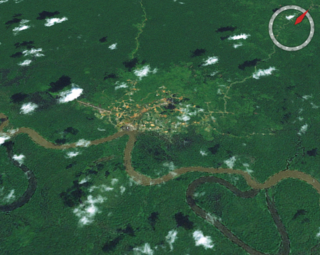
Tabubil is a town, company operated township located in the Star Mountains area of the North Fly District of Western Province, Papua New Guinea. The town, including the adjoining relocated village of Wangabin and the industrial area of Laydown, is the largest settlement in the province, although the provincial capital, Daru is a similar size. It had a recorded population of 10,270 at the 2011 census.

Ok Tedi Mine Papua New Guinean copper and gold mine

The Ok Tedi Mine is an open-pit copper and gold mine in Papua New Guinea located near the headwaters of the Ok Tedi River, in the Star Mountains Rural LLG of the North Fly District of the Western Province of Papua New Guinea. Discharges from the mine have caused widespread and diverse harm, both environmentally and socially, to the 50,000 people who live in the 120 villages downstream of the mine.

Ok Tedi Mining Limited company

Ok Tedi Mining Limited is a Papua New Guinean company that administers the Ok Tedi Mine in the northern part of the Western Province. Its main office is located in Tabubil and the building is known as the White House. Its chairman, since 2014, has been former Deputy Prime Minister Moi Avei.

Ok Tedi environmental disaster

The Ok Tedi environmental disaster caused severe harm to the environment along 1,000 kilometres (620 mi) of the Ok Tedi River and the Fly River in the Western Province of Papua New Guinea between about 1984 and 2013. The lives of 50,000 people have been disrupted. One of the worst environmental disasters caused by humans, it is a consequence of the discharge of about two billion tons of untreated mining waste into the Ok Tedi from the Ok Tedi Mine, an open pit mine in the Western Province of Papua New Guinea.

Kiunga-Tabubil Highway road in Papua New Guinea

The Kiunga-Tabubil Highway is an all-weather gravel road that runs from the river port town of Kiunga through Ningerum and Tabubil to the Ok Tedi Mine site, in the remote North Fly District of the Western Province of Papua New Guinea. The road is around 137 kilometres (85 mi) long, but this changes as sections are rehashed.

Kiunga Urban LLG Local-level government in Papua New Guinea

Kiunga Urban LLG is a local-level government area situated in North Fly District of Western Province of Papua New Guinea. In the year 2000, the LLG had a population of 8265 people. The township of Kiunga, which is governed by this LLG is the government seat of the district.

Middle Fly District Place in Western Province, Papua New Guinea

The Middle Fly District of the Western Province of Papua New Guinea is a large, coastal district that forms the central area of the Fly River basin. It contains the Local-Level Government areas of: Balimo Urban, Bamu Rural, Gogodaia Rural, Lake Murray Rural, and Nomad Rural, and the population centres of Balimo, Bamu, Gogodala and Nomad. It also contains the largest lake in the country, Lake Murray.

The glass blue-eye is a species of fish in the subfamily Pseudomugilinae. It is endemic to Papua New Guinea where it is only known to occur in a few small creeks adjacent to a 15–20 kilometres (9.3–12.4 mi) stretch of the Ok Tedi Mine supply road between the settlements of Kiunga and Tabubil in the Upper Fly River system close to the frontier with Irian Jaya. This species has a mainly transparent body with silvery gill covers and belly, there are black spots on the margins of the scales and there are black markings on the fins and lateral line, with the fins being shaded with yellow, with the exception of the transparent pectoral fins. It attains a standard length of 3 centimetres (1.2 in).This species was described by Gerald R. Allen in 1983 and its specific name honours the site biologist at the Ok Tedi Mine, David Balloch, for the support and assistance he gave Allen.

The Birim River or Ok Birim in the western province of New Guinea is a tributary of the Ok Tedi River, which is in turn a tributary of the north Fly River. The Birim river joins the Ok Tedi river from the west between Ningerum and Bige. The Birim river area is inhabited by the Yonggom tribe. They practise tropical forest Swidden agriculture. About 3,000 people, they speak the Ninggerum language of the Ok group.

References

  1. 1 2 3 4 "Population by Statistical LLG Areas (Western Province)". Papua New Guinea Business and Tourism. 2002.
  2. 1 2 3 4 5 6 7 8 9 10 11 12 13 14 "Quick Facts". North Fly District Tourism. 2007.
  3. "About Us". Ok Tedi Mining Limited. 2007. Archived from the original on 2007-04-16.