The Wopkaimin are a small aboriginal tribe that lives in the remote Star Mountains in western Papua New Guinea in what is known as the Fly River socio-ecological region. The tribe speaks Faiwol.

Wewak is the capital of the East Sepik province of Papua New Guinea. It is located on the northern coast of the island of New Guinea. It is the largest town between Madang and Jayapura. It is the see city (seat) of the Roman Catholic Diocese of Wewak.
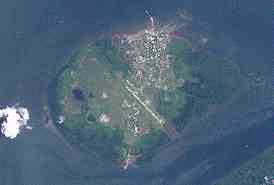
Daru is the capital of the Western Province of Papua New Guinea and a former Catholic bishopric. Daru town falls under the jurisdiction of Daru Urban LLG.

The Ok Tedi is a river in New Guinea. The Ok Tedi Mine is located near the headwaters of the river, which is sourced in the Star Mountains. It is the second largest tributary of the Fly River. Nearly the entirety of the river runs through the North Fly District of the Western Province of Papua New Guinea, but the river crosses the international boundary with Indonesia for less than one kilometre. The largest settlement of the Western Province, Tabubil is located near its banks.

Mount Hagen is the third largest city in Papua New Guinea, with a population of 46,250. It is the capital of the Western Highlands Province and is located in the large fertile Wahgi Valley in central mainland Papua New Guinea, at an elevation of 1,677 m (5,502 ft).

Tabubil is a town located in the Star Mountains area of the North Fly District of Western Province, Papua New Guinea. The town, including the adjoining relocated village of Wangabin and the industrial area of Laydown, is the largest settlement in the province, although the provincial capital, Daru is a similar size. It had a recorded population of 10,270 at the 2011 census.
PNG Air is an airline based on the grounds of Jacksons International Airport, Port Moresby, Papua New Guinea. It operates scheduled domestic and international flights, as well as contract corporate charter work. Its main base is Jacksons International Airport.

The Ok Tedi Mine is an open-pit copper and gold mine in Papua New Guinea located near the headwaters of the Ok Tedi River, in the Star Mountains Rural LLG of the North Fly District of the Western Province of Papua New Guinea.
Mendi, Papua New Guinea, is the provincial capital of the Southern Highlands Province. The Lai River flows by the town. It is served by Mendi Airport. The town falls under Mendi Urban LLG.
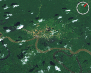
Kiunga is a port town on the Fly River in the Western Province of Papua New Guinea, just upstream from the D'Albertis Junction with the Ok Tedi River. It is the southernmost terminus of the Kiunga-Tabubil Highway. Local industry rests on a cornerstone of freight and haulage, particularly from the Ok Tedi Mine and provisioning for the much larger town of Tabubil. Natural rubber has been an emerging industry more recently, with a processing/manufacturing plant being built in town.

Wabag is the capital of Enga Province, Papua New Guinea. It is the least populous provincial capital in the country. It is on the Lai River; the Highlands Highway passes through the town, between Mount Hagen and Porgera. Europeans first visited the site in 1938-39 A radio camp and airstrip were established in 1938-39 but restrictions on transportation and the surrounding land's infertility long inhibited Wabag's development.
Tabubil Airport is an international airport in Tabubil, Papua New Guinea. Asia Pacific Airlines operates out of Tabubil as its hub.

The Kiunga-Tabubil Highway is an all-weather gravel road that runs from the river port town of Kiunga through Ningerum and Tabubil to the Ok Tedi Mine site, in the remote North Fly District of the Western Province of Papua New Guinea. The road is around 137 kilometres (85 mi) long, but this changes as sections are rehashed.

The North Fly District of the Western Province of Papua New Guinea is the northernmost, smallest, and arguably the most remote of the three districts of the province. It contains the Local-Level Government (LLG) areas of Kiunga Rural, Kiunga Urban, Ningerum Rural, Olsobip Rural and Star Mountains Rural, and the townships of Kiunga, Tabubil, Olsobip and Ningerum.

Star Mountains Rural LLG is a local-level government situated in the Star Mountains in North Fly District of Western Province of Papua New Guinea. In the year 2000, the LLG had 1691 homes, and a population of 12,114 people. The current population is more likely to now be around 15,000 people. The main population centre in the LLG is Tabubil. Finalbin and the Ok Tedi Mine are also in this LLG.

Ningerum Rural LLG is a local-level government area situated in North Fly District of Western Province of Papua New Guinea. In the year 2000, the LLG had a population of 13,156 people. The main population centre is Ningerum.

Kiunga Rural LLG is a local-level government area situated in North Fly District of Western Province of Papua New Guinea. In the year 2000, the LLG had a population of 13,249 people. The township of Kiunga is within the boundaries of this LLG, but has its own urban LLG.
Gasmata is a village on the southern coast of New Britain, Papua New Guinea located at 6° 16' 60S 150° 19' 60E. There is a Gasmata Airport in Surumi Peninsula area adjacent. The village is administered under Gasmata Rural LLG in East New Britain Province.

