
Wewak is the capital of the East Sepik province of Papua New Guinea. It is on the northern coast of the island of New Guinea. It is the largest town between Madang and Jayapura. It is the see city (seat) of the Roman Catholic Diocese of Wewak.

Western Province is a coastal province in southwestern Papua New Guinea, bordering the Indonesian provinces of Highland Papua and South Papua. The provincial capital is Daru. The largest town in the province is Tabubil. Other major settlements are Kiunga, Ningerum, Olsobip and Balimo.

East Sepik is a province in Papua New Guinea. Its capital is Wewak. East Sepik has an estimated population of 433,481 people and is 43,426 km square in size.
Tabubil is a town located in the Star Mountains area of the North Fly District of Western Province, Papua New Guinea. The town, including the adjoining relocated village of Wangabin and the industrial area of Laydown, is the largest settlement in the province, although the provincial capital, Daru is a similar size. It had a recorded population of 10,270 at the 2011 census.

Samarai is an island and former administrative capital in Milne Bay Province, Papua New Guinea.

The Ok Tedi Mine is an open-pit copper and gold mine in Papua New Guinea located near the headwaters of the Ok Tedi River, in the Star Mountains Rural LLG of the North Fly District of the Western Province of Papua New Guinea.
Mendi, Papua New Guinea, is the provincial capital of the Southern Highlands Province. The Lai River flows by the town. It is served by Mendi Airport. The town falls under Mendi Urban LLG.
The Ata language, also known as Pele-Ata after its two dialects, or Wasi, is a Papuan language spoken on New Britain island, Papua New Guinea. It appears to be related to neighboring Anêm, and possibly also to Yélî Dnye in a proposed Yele-West New Britain family. There are about 2000 speakers.
Kiunga is a port town on the Fly River in the Western Province of Papua New Guinea, just upstream from the D'Albertis Junction with the Ok Tedi River. It is the southernmost terminus of the Kiunga-Tabubil Highway. Local industry rests on a cornerstone of freight and haulage, particularly from the Ok Tedi Mine and provisioning for the much larger town of Tabubil. Natural rubber has been an emerging industry more recently, with a processing/manufacturing plant being built in town.

Kiwai Island is the largest island in the Fly River delta, Papua New Guinea. It is one of the Torres Strait Islands. It is 59 km long along the northwest–southeast axis from Wamimuba Point in the northwest to the village of Saguane (Sanguane) in the south, and up to 9 km wide, with an average width of 5.6 km. Its area is 359 km2. Neighboring Purutu and Wabuda Islands to the north and northeast are also among the three largest islands in the Fly River delta. A language study mentioned a population of about 4500, but the census of population of 2000 showed only 2092 inhabitants.

The North Fly District of the Western Province of Papua New Guinea is the northernmost, smallest, and arguably the most remote of the three districts of the province. It contains the Local-Level Government (LLG) areas of Kiunga Rural, Kiunga Urban, Ningerum Rural, Olsobip Rural and Star Mountains Rural, and the townships of Kiunga, Tabubil, Olsobip and Ningerum.

Olsobip Rural LLG is a local-level government situated in North Fly District of Western Province of Papua New Guinea. In the year 2000, the LLG was the least populous of the district, with a population of only 3851 people. The capital of the LLG is a station town by the name of Olsobip.

The Middle Fly District of the Western Province of Papua New Guinea is a large, coastal district that forms the central area of the Fly River basin. It contains the Local-Level Government areas of: Balimo Urban, Bamu Rural, Gogodaia Rural, Lake Murray Rural, and Nomad Rural, and the population centres of Balimo, Bamu, Gogodala and Nomad. It also contains the largest lake in the country, Lake Murray.

New Guinea is the world's second-largest island, with an area of 785,753 km2 (303,381 sq mi). Located in Melanesia in the southwestern Pacific Ocean, the island is separated from Australia by the 150-kilometre wide Torres Strait, though both landmasses lie on the same continental shelf. Numerous smaller islands are located to the west and east. The name "New Guinea" was given by Spanish explorer Yñigo Ortiz de Retez during his maritime expedition of 1545 due to the resemblance of the indigenous peoples of the island to those in the African region of Guinea.

The Yam languages, also known as the Morehead River languages, are a family of Papuan languages. They include many of the languages south and west of the Fly River in Papua New Guinea and Indonesian West Papua.

Pawaia, also known as Sira, Tudahwe, Yasa, is a Papuan language that forms a tentative independent branch of the Trans–New Guinea family in the classification of Malcolm Ross (2005).
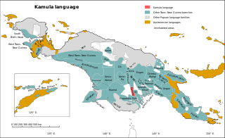
Kamula is a Trans–New Guinea language that is unclassified within that family in the classification of Malcolm Ross (2005). Noting insufficient evidence, Pawley and Hammarström (2018) leave it as unclassified.
Bogaya (Pogaya) is a Papuan language of Papua New Guinea. In Western Province, Bogaya is spoken in Olsobip Rural LLG and Nomad Rural LLG. It is also spoken in Koroba-Kopiago District, Hela Province.

Tabo, also known as Waia (Waya), is a Papuan language of Western Province, Papua New Guinea, just north of the Fly River delta. The language has also been known as Hiwi and Hibaradai.
The Morehead River is a river in southwestern Papua New Guinea. It is located just to the east of the Bensbach River, and to the west of the Fly River. The river flows through the Trans-Fly savanna and grasslands.

