Daru

Last updated
Daru
Town
Daru Island (Landsat).jpg
Papua New Guinea location map.svg
Red pog.svg
Daru
Location in Papua New Guinea
Coordinates: 9°05′S143°12′E / 9.083°S 143.200°E / -9.083; 143.200
CountryFlag of Papua New Guinea.svg  Papua New Guinea
Province Western Province
District South Fly District
LLGDaru Urban
Established1884
Elevation
3 m (10 ft)
Population
[1]
  Total15,142
 2011
Time zone UTC+10 (AEST)
Climate Am
Location440 km (270 mi) from Port Moresby by air

Daru is the capital of the Western Province of Papua New Guinea [2] and a former Catholic bishopric. Daru town falls under the jurisdiction of Daru Urban LLG.

Contents

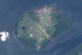
The township is entirely located on an island that goes by the same name, which is located near the mouth of the Fly River on the western side of the Gulf, just north of Torres Strait and Far North Queensland in Australia. Daru had a recorded population of 15,142 as of the 2011 census. [1]

Population

The language of the Daru people is Kiwai (South-West Coastal Kiwai), also spoken on neighbouring mainland villages (the name Kiwai comes from Kiwai Island some 60 km north-east in the Fly River delta). However, the Kiwai settlement of Daru is fairly recent. The original inhabitants, the Hiamo, were Western-Central Torres Strait Islanders originally from Yama in the Torres Strait. With the Kiwai colonisations, the main group of Hiamo people moved to Southern Torres Strait and settled the (Inner) Muralag group.

Religion

Its St. Louis de Montfort Co-Cathedral [3] is the 'second see' (and former 'full' cathedral) of the Roman Catholic Diocese of Daru-Kiunga (renamed in 1987, originally Apostolic Prefecture of Daru since 1957, promoted diocese in 1966).

Transport

It is served by Daru Airport, a small airstrip.

Climate

Daru has a tropical monsoon climate (Köppen Am) with heavy rainfall most of the year and low rainfall from July to October.

Climate data for Daru
MonthJanFebMarAprMayJunJulAugSepOctNovDecYear
Mean daily maximum °C (°F)31.7
(89.1)
31.7
(89.1)
31.2
(88.2)
30.6
(87.1)
29.9
(85.8)
28.9
(84.0)
28.2
(82.8)
28.4
(83.1)
29.2
(84.6)
30.6
(87.1)
31.8
(89.2)
32.4
(90.3)
30.4
(86.7)
Daily mean °C (°F)27.5
(81.5)
27.5
(81.5)
27.2
(81.0)
27.0
(80.6)
26.8
(80.2)
25.9
(78.6)
25.2
(77.4)
25.4
(77.7)
25.8
(78.4)
26.8
(80.2)
27.6
(81.7)
28.0
(82.4)
26.7
(80.1)
Mean daily minimum °C (°F)23.4
(74.1)
23.3
(73.9)
23.3
(73.9)
23.5
(74.3)
23.7
(74.7)
23.0
(73.4)
22.3
(72.1)
22.4
(72.3)
22.5
(72.5)
23.1
(73.6)
23.5
(74.3)
23.6
(74.5)
23.1
(73.6)
Average rainfall mm (inches)265
(10.4)
264
(10.4)
291
(11.5)
333
(13.1)
224
(8.8)
110
(4.3)
80
(3.1)
54
(2.1)
45
(1.8)
55
(2.2)
109
(4.3)
191
(7.5)
2,021
(79.5)
Source: [4]

See also

Notes and references

  1. 1 2 "Census Figures by Wards - Southern Region". National Population & Housing Census 2011. Archived from the original on 30 October 2019. Retrieved 31 March 2017.
  2. "Japan Steps Up Interest in Papua New Guinea's Gas Riches". Wall Street Journal. 23 May 2013. Archived from the original on 5 June 2013.
  3. http://www.gcatholic.org/churches/oceania/2929.htm GCatholic, with Google satellite map
  4. "Daru Climate (Papua New Guinea)". climate-data.org.

Related Research Articles

<span class="mw-page-title-main">Torres Strait</span> Navigable sea passage between Australia and New Guinea

The Torres Strait, also known as Zenadh Kes, is a strait between Australia and the Melanesian island of New Guinea. It is 150 km (93 mi) wide at its narrowest extent. To the south is Cape York Peninsula, the northernmost extremity of the Australian mainland. To the north is the Western Province of Papua New Guinea. It is named after the Spanish navigator Luís Vaz de Torres, who sailed through the strait in 1606.

<span class="mw-page-title-main">Torres Strait Islands</span> Group of islands in the Torres Strait between Australia and New Guinea

The Torres Strait Islands are an archipelago of at least 274 small islands in the Torres Strait, a waterway separating far northern continental Australia's Cape York Peninsula and the island of New Guinea. They span an area of 48,000 km2 (19,000 sq mi), but their total land area is 566 km2 (219 sq mi).

<span class="mw-page-title-main">Fly River</span> River in Papua New Guinea

The Fly River is the third longest river in the island of New Guinea, after the Sepik River and Mamberamo River, with a total length of 1,060 km (660 mi). It is the largest by volume of discharge in Oceania, the largest in the world without a single dam in its catchment, and overall the 20th-largest primary river in the world by discharge volume. It is located in the southwest of Papua New Guinea and in the South Papua province of Indonesia. It rises in the Victor Emanuel Range arm of the Star Mountains, and crosses the south-western lowlands before flowing into the Gulf of Papua in a large delta. The Fly-Strickland River system has a total length of 1,220 km (760 mi), making it the longest river system of an island in the world. The 824 km (512 mi) Strickland River is the longest and largest tributary of Fly River, making it the farthest distance source of the Fly River.

<span class="mw-page-title-main">Boigu Island (Queensland)</span> Suburb of Torres Strait Island Region, Queensland, Australia

Boigu Island is the most northerly inhabited island of Queensland and of Australia. It is part of the Top Western group of the Torres Strait Islands, which lie in the Torres Strait separating Cape York Peninsula from the island of New Guinea. The mainland of Papua New Guinea is only 6 kilometres (3.7 mi) away from Boigu. Boigu has an area of 89.6 square kilometres (34.6 sq mi). Boigu Island is the name of the locality on the island within the Torres Strait Island Region. Boigu is predominantly inhabited by indigenous Torres Strait Islanders. In the 2021 census, the population of the island was 199, of whom 189 people or 95% of the population identified as Indigenous Australians.

<span class="mw-page-title-main">Western Province (Papua New Guinea)</span> Place in Papua New Guinea

Western Province is a coastal province in southwestern Papua New Guinea, bordering the Indonesian provinces of Highland Papua and South Papua. The provincial capital is Daru. The largest town in the province is Tabubil. Other major settlements are Kiunga, Ningerum, Olsobip and Balimo.

<span class="mw-page-title-main">Horn Island, Queensland</span> Suburb of Shire of Torres, Queensland, Australia

Horn Island, or Ngurupai/Narupai in the local language, is an island of the Torres Strait Islands archipelago located in the Torres Strait, in Queensland in Northern Australia between the Australian mainland and Papua New Guinea. It is within the locality of Horn within the Shire of Torres; the boundaries of the locality include the island itself and surrounding waters of the Torres Strait. The town of Wasaga is on the north-western coast of the island. In the 2021 census, the locality of Horn had a population of 533 people.

<span class="mw-page-title-main">Vanimo</span> Place in Sandaun Province, Papua New Guinea

Vanimo is the capital of Sandaun Province in north-westernmost Papua New Guinea and of Vanimo-Green River District. It is located on a peninsula close to the border with Indonesia, nearest to Jayapura, the capital city of Papua (province).

<span class="mw-page-title-main">Trans-Fly–Bulaka River languages</span>

The Trans-Fly – Bulaka RiverakaSouth-Central Papuan languages form a hypothetical family of Papuan languages. They include many of the languages west of the Fly River in southern Papua New Guinea into southern Indonesian West Papua, plus a pair of languages on the Bulaka River a hundred km further west.

<span class="mw-page-title-main">Meriam language</span> Trans-Fly language of the Australian Torres Strait Islands

Meriam or the Eastern Torres Strait language is the language of the people of the small islands of Mer, Waier and Dauar, Erub, and Ugar in the eastern Torres Strait, Queensland, Australia. In the Western Torres Strait language, Kalaw Lagaw Ya, it is called Mœyam or Mœyamau Ya. It is the only Papuan language in Australian territory.

<span class="mw-page-title-main">Yam Island</span> Suburb of Torres Strait Island Region, Queensland, Australia

Yam Island, called Yama or Iama in the Kulkalgau Ya language or Turtle-backed Island in English, is an island of the Bourke Isles group of the Torres Strait Islands, located in the Tancred Passage of the Torres Strait in Queensland, Australia. The island is situated approximately 100 kilometres (62 mi) northeast of Thursday Island and measures about 2 square kilometres (0.77 sq mi). The island is an official locality known as Iama Island within the local government area of Torres Strait Island Region. The town, also called Yam Island, is located on the north-west coast of the island. In the 2021 census, Iama Island had a population of 275 people.

<span class="mw-page-title-main">Merauke</span> Capital district of Merauke Regency

Merauke, also known as the District of Merauke, is a large town in South Papua, Indonesia. It is also the administrative centre of Merauke Regency. It is considered the easternmost city in Indonesia. The town was originally called Ermasoe. It is next to the Maro River where the Port of Merauke is located. As of the 2010 census, Merauke had a population of 87,634 which at the 2020 Census had increased to 102,351.

<span class="mw-page-title-main">Daru Airport</span> Airport in Daru, Papua New Guinea

Daru Airport is an airport serving Daru, the capital of the Western Province in Papua New Guinea.

<span class="mw-page-title-main">Daru Island</span> Island in the Western Province of Papua New Guinea

Daru Island is an island in the Western Province of Papua New Guinea. It is one of the Torres Strait Islands. The eponymous town on the island is the capital of the province, and houses the vast majority of the island's population of 20,524 (2009). Daru Island is elliptical in shape, with dimensions of 5.0 by 3.7 kilometers, an area of 14.7 km², and an elevation of up to 27 m. The island is separated from the mainland in the north, specifically the mouth of Oriomo River, by the 3.5 km wide Daru Roads. The shortest distance to the larger Bristow Island in the south is 1.3 km.

<span class="mw-page-title-main">Kiwai Island</span>

Kiwai Island is the largest island in the Fly River delta, Papua New Guinea. It is one of the Torres Strait Islands. It is 59 km long along the northwest–southeast axis from Wamimuba Point in the northwest to the village of Saguane (Sanguane) in the south, and up to 9 km wide, with an average width of 5.6 km. Its area is 359 km2. Neighboring Purutu and Wabuda Islands to the north and northeast are also among the three largest islands in the Fly River delta. A language study mentioned a population of about 4500, but the census of population of 2000 showed only 2092 inhabitants.

<span class="mw-page-title-main">New Guinea</span> Island in the Pacific Ocean

New Guinea is the world's second-largest island, with an area of 785,753 km2 (303,381 sq mi). Located in Melanesia in the southwestern Pacific Ocean, the island is separated from Australia by the 150-kilometre wide Torres Strait, though both landmasses lie on the same continental shelf, and were united during episodes of low sea level in the Pleistocene glaciations as the combined landmass of Sahul. Numerous smaller islands are located to the west and east. The island's name was given by Spanish explorer Yñigo Ortiz de Retez during his maritime expedition of 1545 due to the resemblance of the indigenous peoples of the island to those in the African region of Guinea.

<span class="mw-page-title-main">Bramble Cay</span> Island in Queensland, Australia

Bramble Cay, also known as Maizab Kaur and Massaramcoer, is a small cay located at the northeastern edge of Australia and the Torres Strait Islands of Queensland and at the northern end of the Great Barrier Reef. Lying around 50 km (31 mi) north of Erub Island in the Gulf of Papua, it is the northernmost point of land of Australia and marks the end of the Great Barrier Reef.

<span class="mw-page-title-main">Parama Island</span> Island in Papua New Guinea

Parama Island is an island close off the south coast of Papua New Guinea. It is located 17 km east of Daru, the provincial capital of Western Province, at the southernmost extreme of the Fly River delta, and at the northeastern corner of the Torres Strait. It is the northernmost of the Torres Strait Islands, and at the same time the southernmost of the Fly River delta. Bampton Point, its southernmost point, marks the southwestern corner of the Gulf of Papua. The Coral Sea is southeast. Torres Strait is south and southwest, specifically the Great Northeast Channel, which separates Parama Island from the closest Australian (Queensland) island, Bramble Cay, 48 km ESE.

<span class="mw-page-title-main">South Fly District</span> Place in Western Province, Papua New Guinea

South Fly District is a district of the Western Province of Papua New Guinea. Its capital is Daru. The area of the district is 31,864 km², with a population of 46,407 at the 2000 census.

Kiwai is a Papuan language, or languages, of southern Papua New Guinea. Dialects number 1,300 Kope, 700 Gibaio, 1,700 Urama, 700 Arigibi, 3,800 Coast, 1,000 Daru, 4,500 Island, 400 Doumori. Wurm and Hattori (1981) classify Arigibi as a separate language.

Wipi, also known as Gidra, Jibu or Oriomo, is a Papuan language of New Guinea. It is a member of the Eastern Trans-Fly family, the other languages of this family being Gizrra, Meriam Mir and Bine. The family has influenced the neighbouring Kiwai language as well as Kalau Lagau Ya.