National Capital District (Papua New Guinea)

Last updated
National Capital District (NCD)
Nesenel Kapitol Distrik (Tok Pisin)
Flag of NCD.svg
PNG NCD Logo.png
National Capital District in Papua New Guinea (special marker).svg
NCD in Papua New Guinea
Coordinates: 9°4′S147°2′E / 9.067°S 147.033°E / -9.067; 147.033
Country Flag of Papua New Guinea.svg  Papua New Guinea
Established16 September 1975
Capital Port Moresby
Districts
Government
  Governor Powes Parkop
Area
  Total240 km2 (90 sq mi)
Population
 (2011 census)
  Total364,125
  Density1,500/km2 (3,900/sq mi)
Time zone UTC+10:00 (PNGST)
HDI (2019)0.725 [1]
high · 1st of 22
Website ncdc.gov.pg

The National Capital District of Papua New Guinea is the incorporated area around Port Moresby, which is the capital of Papua New Guinea. Although it is surrounded by Central Province, where Port Moresby is also the capital, it is technically not a part of that province. It covers an area of 240 km2 and has a population of 364,125 (2011 census). [2] [3] It is represented by three open MPs and an NCD-wide representative in the National Parliament of Papua New Guinea who acts as Governor of the National Capital District; however, these MPs do not have the same powers as elsewhere in the country due to the role of the National Capital District Commission. [4]

Contents

Governors

The National Capital District did not have a decentralised administration with a Premier, as with the other provinces, prior to 1995; however, since the 1995 reforms of provincial governments it has been headed by a Governor, albeit one with more limited powers. [5]

PremierTerm
Bill Skate 1995–1997
Philip Taku 1997–1999
run by managers1999–2001
Philip Taku 2001
run by managers2001–2006
Wari Vele 2006–2007
Powes Parkop 2007–present

Local-level governments

Local-level governments of National Capital District are: [6] [7]

DistrictDistrict CapitalLLG Name
National Capital District Port Moresby Gerehu Urban
Waigani-University Urban
Tokarara-Hohola Urban
Gordons-Saraga Urban
Boroko-Korobosea Urban
Kilakila-Kaugere Urban
Town-Hanuabada Urban
Laloki-Napanapa Urban
Bomana Urban

Electorates

A map of the three open electorates in the National Capital District. Port Moresby open electorates.svg
A map of the three open electorates in the National Capital District.

In the National Parliament of Papua New Guinea, the National Capital District is represented by three open electorates and one provincial electorate.

Electorates in the National Capital District
(as of the 2022 general election)
ElectorateMemberParty
Moresby North-East Open John Kaupa Pangu
Moresby North-West Open Lohia Boe Samuel Pangu
Moresby South Open Justin Tkatchenko SDP
NCD Provincial Powes Parkop SDP

Related Research Articles

<span class="mw-page-title-main">Sandaun Province</span> Place in Papua New Guinea

Sandaun Province is the northwesternmost mainland province of Papua New Guinea. It covers an area of 35,920 km2 and has a population of 248,411. The capital is Vanimo. In July 1998 the area surrounding the town of Aitape was hit by an enormous tsunami caused by a Magnitude 7.0 earthquake which killed over 2,000 people. The five villages along the west coast of Vanimo towards the International Border are namely; Lido, Waromo, Yako, Musu and Wutung.

<span class="mw-page-title-main">Madang Province</span> Province of Papua New Guinea

Madang is a province of Papua New Guinea. The province is on the northern coast of mainland Papua New Guinea and has many of the country's highest peaks, active volcanoes and its biggest mix of languages. The capital is the town of Madang.

<span class="mw-page-title-main">Chimbu Province</span> Province in Papua New Guinea

Chimbu, more frequently spelled Simbu, is a province in the Highlands Region of Papua New Guinea. The province has an area of 6,112 km2 and a population of 376,473. The capital of the province is Kundiawa. Mount Wilhelm, the tallest mountain in Papua New Guinea is on the border of Eastern part of Simbu and the Western part of Madang Province.

<span class="mw-page-title-main">Oro Province</span> Place in Papua New Guinea

Oro Province, formerly Northern Province, is a coastal province in the Southern Region of Papua New Guinea. The provincial capital is Popondetta. The province covers 22,800 km2, and has 176,206 inhabitants. The province shares land borders with Morobe Province to the northwest, Central Province to the west and south, and Milne Bay Province to the southeast. The province is located within the Papuan Peninsula.

<span class="mw-page-title-main">Western Highlands Province</span> Place in Papua New Guinea

Western Highlands is a province of Papua New Guinea. The provincial capital is Mount Hagen. The province covers an area of 4,299 km2, and there are 362,850 inhabitants, making the Western Highlands the most densely populated province. Tea and coffee are grown in the Western Highlands.

<span class="mw-page-title-main">Eastern Highlands Province</span> Place in Papua New Guinea

Eastern Highlands is a highlands province of Papua New Guinea. The provincial capital is Goroka. The province covers an area of 11,157 km², and has a population of 579,825. The province shares a common administrative boundary with Madang Province to the north, Morobe Province to the east, Gulf Province to the south, and Simbu Province to the west. The province is the home of the Asaro mud mask that is displayed at shows and festivals within the province and in the country. The province is reachable by air, including Goroka Airport, and road transport, including the main Highlands Highway.

<span class="mw-page-title-main">Southern Highlands Province</span> Place in Papua New Guinea

Southern Highlands is a province in Papua New Guinea. Its provincial capital is the town of Mendi. According to Papua New Guinea's national 2011 census, the total population of Southern Highlands is 515,511 spread across 15,089 square kilometers (5,826 sq mi).

<span class="mw-page-title-main">East Sepik Province</span> Province of Papua New Guinea

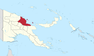
East Sepik is a province in Papua New Guinea. Its capital is Wewak. East Sepik has an estimated population of 433,481 people and is 43,426 km square in size.

<span class="mw-page-title-main">Central Province (Papua New Guinea)</span> Place in Papua New Guinea

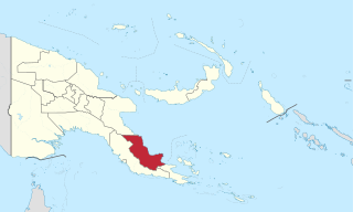
Central Province is a province in Papua New Guinea located on the southern coast of the country. It has a population of 237,016 people and is 29,998 square kilometres (11,582 sq mi) in size. The seat of government of Central Province, which is located within the National Capital District outside the province, is the Port Moresby suburb of Konedobu. On 9 October 2007, the Central Province government announced plans to build a new provincial capital city at Bautama, which lies within Central Province near Port Moresby, although there has been little progress in constructing it.

<span class="mw-page-title-main">Southern Region, Papua New Guinea</span> Region in Papua New Guinea

Southern Region is one of four regions of Papua New Guinea. The region includes the national capital Port Moresby.

<span class="mw-page-title-main">Local-level governments of Papua New Guinea</span>

Papua New Guinea has 326 local-level governments (LLGs) comprising 6,112 wards as of 2018.

<span class="mw-page-title-main">Districts of Papua New Guinea</span> Second-level administrative division

This page is a list of districts of Papua New Guinea.

<span class="mw-page-title-main">Nuku, Papua New Guinea</span>

Nuku, also known as Nuku Station, is the capital of Nuku District in Sandaun Province, Papua New Guinea. It is located within Mawase Rural LLG.

<span class="mw-page-title-main">Jiwaka Province</span> Province in Papua New Guinea

Jiwaka is a province of Papua New Guinea. The government gazetted provincial capital is located in Kurumul. Temporarily all provincial matters are handled in Minj after the election of the new Governor in 2022 general elections. Matters concerning each district are dealt with at their respective district administration office.

<span class="mw-page-title-main">Hela Province</span> Place in Papua New Guinea

Hela is a province of Papua New Guinea. The provincial capital is Tari. The province covers an area of 10,498 km², and there are 249,449 inhabitants. Hela province officially came into being on 17 May 2012, comprising three districts previously part of Southern Highlands Province.

Waigani-University Urban LLG is a local-level government (LLG) of National Capital District, Papua New Guinea.

Tokarara-Hohola Urban LLG is a local-level government (LLG) of National Capital District, Papua New Guinea.

Town-Hanuabada Urban LLG is a local-level government (LLG) of National Capital District, Papua New Guinea.

Laloki-Napanapa Urban LLG is a local-level government (LLG) jurisdiction of National Capital District, Papua New Guinea.

Bomana Urban LLG is a local-level government (LLG) of National Capital District, Papua New Guinea.

References

  1. "Sub-national HDI - Area Database - Global Data Lab". hdi.globaldatalab.org. Retrieved 2020-04-18.
  2. Papua New Guinea 2000 Census: Western. National Statistical Office. p. 7.
  3. "Census Figures by Wards - Southern Region". National Population & Housing Census 2011. Retrieved 31 March 2017.
  4. "National Capital District (Port Moresby)". One PNG. Retrieved 1 April 2017.
  5. "Provinces". rulers.org. Retrieved 31 March 2017.
  6. "Census Figures by Wards - Southern Region". www.nso.gov.pg. 2011 National Population and Housing Census: Ward Population Profile. Port Moresby: National Statistical Office, Papua New Guinea. 2014.
  7. "Final Figures". www.nso.gov.pg. 2011 National Population and Housing Census: Ward Population Profile. Port Moresby: National Statistical Office, Papua New Guinea. 2014.