Jiwaka Province

Last updated
Jiwaka Province
Jiwaka Provins (Tok Pisin)
Flag of Jiwaka.svg
Jiwaka in Papua New Guinea.svg
Jiwaka Province in Papua New Guinea
Coordinates: 6°0′S144°35′E / 6.000°S 144.583°E / -6.000; 144.583
Country Papua New Guinea
Formation2012
Capital Kurumul
Districts
Government
  Governor Simon Kaiwi (2022-)
Area
  Total4,798 km2 (1,853 sq mi)
Population
 (2011 census)
  Total343,987
  Density72/km2 (190/sq mi)
Time zone UTC+10 (AEST)
HDI (2018)0.539 [1]
low · 15th of 22

Jiwaka is a province of Papua New Guinea. The government gazetted provincial capital is located in Kurumul. Temporarily all provincial matters are handled in Minj after the election of the new Governor in 2022 general elections. Matters concerning each district are dealt with at their respective district administration office.

Contents

The province covers an area of 4,798 km², [2] and there are 343,987 inhabitants (2011 census final figures [3] —2000 census 185,641). Jiwaka province officially came into being on 17 May 2012, [4] comprising three districts [5] [6] previously part of Western Highlands Province. Mount Wilhelm, the tallest mountain in Papua New Guinea, is on the border of Jiwaka.

Etymology

"Jiwaka" is a portmanteau word combining the first two letters each from the word Jimi, Waghi and Kambia. Jimi, Waghi and Kambia denote the topographical landscape referencing the Valley (Waghi Valley) and the mountain ranges at the north (Jimi) and south (Kambia).

Districts and LLGs

There are eight LLGs in Jiwaka's four districts of Minj, Banz, Nondugl and Jiimi. Anglimp rural, Kudjip rural, Minj rural, Minj urban, Nondugl, Banz urban, Banz rural, and Jimi LLGS. districts in the province. Each district has one or more Local Level Government (LLG) areas. For census purposes, the LLG areas are subdivided into wards and those into census units. [7] [8] [9]

DistrictDistrict CapitalLLG Name
Anglimp-South Waghi District Minj Anglimp Rural
South Waghi Rural
Jimi District Tabibuga Jimi Rural
Kol Rural
North Waghi District Banz North Waghi Rural
Nondugl Rural

Provincial leaders

Chairman of the Jiwaka Transitional Authority (2010–2012)

Philip Kapal was later Knighted for his service to PNG politics and the people of Jiwaka.

His term as Chairman during the transitional period has never been smooth. He was met with stiff opposition from individuals with vested political interest. Late Jamie Maxtone-Graham who was member for Anglimp South Waghi moved a 'Private Member's bill in Parliament to have sitting members as Chairman. That law was passed and Benjamin Mul who was North Waghi MP got the nod following rigorous lobbying by Mul and Jamie's cohorts. Following that, there was a spate of court battles leading to the inaugural general elections in 2012.

ChairmanTerm
Philip Kapal 2010–2011

Governors (2012–present)

GovernorTerm
William Tongamp 2012–2022
Simon Kaiwi 2022-present

Members of the National Parliament

The province and each district is represented by a Member of the National Parliament. There is one provincial electorate and each district is an open electorate.

ElectorateMember
Jiwaka Provincial Simon Kaiwi
Anglimp-South Waghi Open Joe Kuli
Jimi Open Wake Goi
North Waghi Open Benjamin Mul

Geography

Jiwaka is located in a very fertile land (Waghi Valley). The Waghi River runs between the valley and most of the people benefit out of it. Besides the Waghi River, the land is naturally fertile and people harvest the best food from it. The 3 resources of the Jiwaka people are coffee, tea and human resources. (SKM-Manda Dam-Tukoi)

Related Research Articles

<span class="mw-page-title-main">Sandaun Province</span> Place in Papua New Guinea

Sandaun Province is the northwesternmost mainland province of Papua New Guinea. It covers an area of 35,920 km2 and has a population of 248,411. The capital is Vanimo. In July 1998 the area surrounding the town of Aitape was hit by an enormous tsunami caused by a Magnitude 7.0 earthquake which killed over 2,000 people. The five villages along the west coast of Vanimo towards the International Border are namely; Lido, Waromo, Yako, Musu and Wutung.

<span class="mw-page-title-main">Madang Province</span> Province of Papua New Guinea

Madang is a province of Papua New Guinea. The province is on the northern coast of mainland Papua New Guinea and has many of the country's highest peaks, active volcanoes and its biggest mix of languages. The capital is the town of Madang.

<span class="mw-page-title-main">Chimbu Province</span> Province in Papua New Guinea

Chimbu, more frequently spelled Simbu, is a province in the Highlands Region of Papua New Guinea. The province has an area of 6,112 km2 and a population of 376,473. The capital of the province is Kundiawa. Mount Wilhelm, the tallest mountain in Papua New Guinea is on the border of Eastern part of Simbu and the Western part of Madang Province.

<span class="mw-page-title-main">Western Highlands Province</span> Place in Papua New Guinea

Western Highlands is a province of Papua New Guinea. The provincial capital is Mount Hagen. The province covers an area of 4,299 km2, and there are 362,850 inhabitants, making the Western Highlands the most densely populated province. Tea and coffee are grown in the Western Highlands.

<span class="mw-page-title-main">Eastern Highlands Province</span> Place in Papua New Guinea

Eastern Highlands is a highlands province of Papua New Guinea. The provincial capital is Goroka. The province covers an area of 11,157 km2, and has a population of 579,825. The province shares a common administrative boundary with Madang Province to the north, Morobe Province to the east, Gulf Province to the south, and Simbu Province to the west. The province is the home of the Asaro mud mask that is displayed at shows and festivals within the province and in the country. The province is reachable by air, including Goroka Airport, and road transport, including the main Highlands Highway.

<span class="mw-page-title-main">Southern Highlands Province</span> Place in Papua New Guinea

Southern Highlands is a province in Papua New Guinea. Its provincial capital is the town of Mendi. According to Papua New Guinea's national 2011 census, the total population of Southern Highlands is 515,511 spread across 15,089 square kilometers (5,826 sq mi).

<span class="mw-page-title-main">East Sepik Province</span> Province of Papua New Guinea

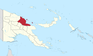
East Sepik is a province in Papua New Guinea. Its capital is Wewak. East Sepik has an estimated population of 433,481 people and is 43,426 km square in size.

<span class="mw-page-title-main">Central Province (Papua New Guinea)</span> Place in Papua New Guinea

Central Province is a province in Papua New Guinea located on the southern coast of the country. It has a population of 237,016 people and is 29,998 square kilometres (11,582 sq mi) in size. The seat of government of Central Province, which is located within the National Capital District outside the province, is the Port Moresby suburb of Konedobu. On 9 October 2007, the Central Province government announced plans to build a new provincial capital city at Bautama, which lies within Central Province near Port Moresby, although there has been little progress in constructing it.

<span class="mw-page-title-main">Districts of Papua New Guinea</span> Second-level administrative division

This page is a list of districts of Papua New Guinea.

<span class="mw-page-title-main">Hela Province</span> Place in Papua New Guinea

Hela is a province of Papua New Guinea. The provincial capital is Tari. The province covers an area of 10,498 km², and there are 249,449 inhabitants. Hela province officially came into being on 17 May 2012, comprising three districts previously part of Southern Highlands Province.

Kup Rural LLG is one of the Local Level Government of Kerowagi District in the Chimbu Province, Papua New Guinea.

South Waghi Rural LLG is a local-level government (LLG) of Jiwaka Province, Papua New Guinea.

Lai Valley Rural LLG - Kulia 741 is a local-level government (LLG) of Southern Highlands Province, Papua New Guinea.

Nembi Plateau Rural LLG is a local-level government (LLG) of Southern Highlands Province, Papua New Guinea. The Nembi language is spoken in the LLG.

Mul Rural LLG is a local-level government (LLG) of Western Highlands Province, Papua New Guinea.

Anglimp Rural LLG is a local-level government (LLG) of Jiwaka Province, Papua New Guinea.

Jimi Rural LLG is a local-level government (LLG) of Jiwaka Province, Papua New Guinea.

Kol Rural LLG is a local-level government (LLG) of Jiwaka Province, Papua New Guinea.

North Waghi Rural LLG is a local-level government (LLG) of Jiwaka Province, Papua New Guinea.

Nondugl Rural LLG is a local-level government (LLG) of Jiwaka Province, Papua New Guinea.

References

  1. "Sub-national HDI - Area Database - Global Data Lab". hdi.globaldatalab.org. Retrieved 2020-04-18.
  2. "Western Highlands Province" (PDF). The National Research Institute. March 2010. Sections for Angalimp South Waghi, Jimi & North Waghi Districts. Archived from the original (PDF) on 2013-11-03. Retrieved 2012-05-22.
  3. "Population at a glance". Archived from the original on 2016-03-27. Retrieved 2015-10-29.
  4. "Hela, Jiwaka declared". The National (Papua New Guinea). 2012-05-17. Retrieved 2012-05-22.
  5. John Pangkatana (2011-09-29). "Anglimp to vote under Jiwaka". Post-Courier Online. Archived from the original on 2012-09-10. Retrieved 2012-05-28.
  6. Yvonne Haip (2012-03-16). "Leaders: Anglimp roll is flawed". The National. Retrieved 2012-05-28.
  7. National Statistical Office of Papua New Guinea
  8. "Census Figures by Wards - Highlands Region". www.nso.gov.pg. 2011 National Population and Housing Census: Ward Population Profile. Port Moresby: National Statistical Office, Papua New Guinea. 2014. Archived from the original on 2019-05-18. Retrieved 2019-06-04.
  9. "Final Figures". www.nso.gov.pg. 2011 National Population and Housing Census: Ward Population Profile. Port Moresby: National Statistical Office, Papua New Guinea. 2014. Archived from the original on 2015-09-06. Retrieved 2019-06-04.