
Papua is a province of Indonesia, comprising the northern coast of Western New Guinea together with island groups in Cenderawasih Bay to the west. It roughly follows the borders of Papuan customary region of Tabi Saireri. It is bordered by the sovereign state of Papua New Guinea to the east, the Pacific Ocean to the north, Cenderawasih Bay to the west, and the provinces of Central Papua and Highland Papua to the south. The province also shares maritime boundaries with Palau in the Pacific. Following the splitting off of twenty regencies to create the three new provinces of Central Papua, Highland Papua, and South Papua on 30 June 2022, the residual province is divided into eight regencies (kabupaten) and one city (kota), the latter being the provincial capital of Jayapura. The province has a large potential in natural resources, such as gold, nickel, petroleum, etc. Papua, along with five other Papuan provinces, has a higher degree of autonomy level compared to other Indonesian provinces.

Papua New Guinea, officially the Independent State of Papua New Guinea, is a country in Oceania that comprises the eastern half of the island of New Guinea and its offshore islands in Melanesia. Its capital, located along its southeastern coast, is Port Moresby. The country is the world's third largest island country, with an area of 462,840 km2 (178,700 sq mi).
Hiri Motu, also known as Police Motu, Pidgin Motu, or just Hiri, is a language of Papua New Guinea, which is spoken in surrounding areas of Port Moresby.

Milne Bay is a province of Papua New Guinea. Its capital is Alotau. The province covers 14,345 km² of land and 252,990 km² of sea, within the province there are more than 600 islands, about 160 of which are inhabited. The province has about 276,000 inhabitants, speaking about 48 languages, most of which belong to the Eastern Malayo-Polynesian branch of the Austronesian language family. Economically the province is dependent upon tourism, oil palm, and gold mining on Misima Island; in addition to these larger industries there are many small-scale village projects in cocoa and copra cultivation. The World War II Battle of Milne Bay took place in the province.

Gulf Province is a province of Papua New Guinea located on the southern coast. The provincial capital is Kerema. The 34,472 km2 province is dominated by mountains, lowland river deltas, and grassland flood plains. In Gulf Province, the Kikori, Turama, Purari, and Vailala rivers meet the Papuan Gulf. The province has the second-smallest population of all the provinces of Papua New Guinea with 106,898 inhabitants. The province shares land borders with Western Province to the west, Southern Highlands, Chimbu, and Eastern Highlands to the north, Morobe Province to the east, and Central Province to the southeast.
Gogodala is the name of an ethnic/language group from the Middle Fly District of the Western Province of Papua New Guinea. They speak the Gogodala language, which belongs to the Trans-New Guinea language family. It is one of about a thousand distinct ethnic groups in the country, each which has its own language and culture.

The Asmat are an ethnic group of New Guinea, residing in the province of South Papua, Indonesia. The Asmat inhabit a region on the island's southwestern coast bordering the Arafura Sea, with lands totaling approximately 18,000 km2 (7,336 mi2) and consisting of mangrove, tidal swamp, freshwater swamp, and lowland rainforest.
The Tolai language, or Kuanua, is spoken by the Tolai people of Papua New Guinea, who live on the Gazelle Peninsula in East New Britain Province.
Huon Peninsula is a large rugged peninsula on the island of New Guinea in Morobe Province, eastern Papua New Guinea. It is named after French explorer Jean-Michel Huon de Kermadec. The peninsula is dominated by the steep Saruwaged and Finisterre and Cromwell Mountains. The nearest large town is the Morobe provincial capital Lae to the south, while settlements on the north coast include the former German town of Finschhafen, the district capital of Wasu, Malalamai and Saidor with its World War II era Saidor Airport.
The Papuans are one of four major cultural groups of Papua New Guinea. The majority of the population lives in rural areas. In isolated areas there remains a handful of the giant communal structures that previously housed the whole male population, with a circling cluster of huts for the women. The Papuan people are Melanesian people composed of at least 240 different peoples, each with its own language and culture. Sago is the staple food of the Papuan supplemented with hunting, fishing and small gardens.
Ankave or Angave is a Papuan language spoken by the approximately 1,600 Angave people in Kerema District, Gulf Province, Papua New Guinea.
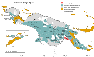
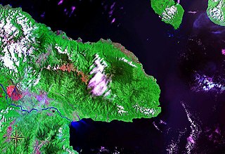
The Eleman languages are a family spoken around Kerema Bay, Papua New Guinea.
Kaki Ae, or Tate, is a language with about 500 speakers, half the ethnic population, near Kerema, in Papua New Guinea. It was previously known by the foreign designation Raeta Tati.
Agriculture in Papua New Guinea has more than a 7,000 years old history, and developed out of pre-agricultural plant/food collecting and cultivation traditions of local hunter-gatherers. Currently around 85% of Papua New Guinea's population lives from semi-subsistence agriculture. 86% of all food energy consumed in Papua New Guinea is locally sourced.
Havila Kavo is a Papua New Guinean politician. He was Governor of the Gulf Province from 2007 to 2017 as a member of the People's National Congress. He briefly lost office in 2010 following a June attempt by opponents in the provincial assembly to oust him; the National Court recognised Pitom Bombom as interim governor in July before reinstating Kavo in August.
Tairuma, also known as Uaripi after its location, is a Trans–New Guinea language spoken in Uaripi in Central Kerema Rural LLG, Gulf Province, Papua New Guinea.

The cuisine of Papua New Guinea are the traditional varied foods found in the eastern part of the New Guinea island. Approximately 80% of the population is reliant on subsistence agriculture, so a large percentage of food energy and protein consumed in Papua New Guinea is produced locally, while the balance is imported. The staple foods in Papua New Guinea includes root crops, bananas, and sago. Papua New Guinea's diet is largely vegetarian, especially in the Gulf and Highlands regions.
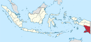
South Papua, officially the South Papua Province, is an Indonesian province located in the southern portion of Papua, following the borders of Papuan customary region of Anim Ha. Formally established on 11 November 2022 and including the four most southern regencies that were previously part of the province of Papua and before 11 December 2002 were all part of a larger Merauke Regency, it covers an area of 117,849.16 km2. It had a population of 522,215 according to the official estimates for mid 2022, making it the least populous province in Indonesia.

