
The geography of Papua New Guinea describes the eastern half of the island of New Guinea, the islands of New Ireland, New Britain and Bougainville, and smaller nearby islands. Together these make up the nation of Papua New Guinea in tropical Oceania, located in the western edge of the Pacific Ocean.
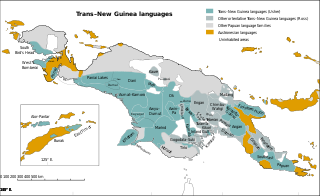
Trans–New Guinea (TNG) is an extensive family of Papuan languages spoken on the island of New Guinea and neighboring islands, a region corresponding to the country Papua New Guinea as well as parts of Indonesia.
Goroka is the capital of the Eastern Highlands Province of Papua New Guinea. It is a town of approximately 19,000 people (2000), 1,600 meters above sea level. It has an airport and is on the "Highlands Highway", about 285 km (177 mi) from Lae in Morobe province and 90 km (56 mi) from the nearby town of Kainantu also in the Eastern Highlands. Other nearby towns include Kundiawa in Simbu Province and Mount Hagen in Western Highlands Province. It has a mild climate, known as a "perpetual Spring".
The Highlands Highway, sometimes known as the Okuk Highway, is the main land highway in Papua New Guinea. It connects several major cities and is vital for the movement of people and goods between the populous Highlands region and the coast.

Mount Wilhelm is the highest mountain in Papua New Guinea at 4,509 metres (14,793 ft). It is part of the Bismarck Range and the peak is the point where three provinces, Chimbu, Jiwaka and Madang, meet. The peak is also known as Enduwa Kombuglu, or Kombugl'o Dimbin, in the local Kuman language.

Chimbu, more frequently spelled Simbu, is a province in the Highlands Region of Papua New Guinea. The province has an area of 6,112 km2 and a population of 376,473. The capital of the province is Kundiawa. Mount Wilhelm, the tallest mountain in Papua New Guinea is on the border of Eastern part of Simbu and the Western part of Madang Province.

Mount Hagen is the third largest city in Papua New Guinea, with a population of 46,250. It is the capital of the Western Highlands Province and is located in the large fertile Wahgi Valley in central mainland Papua New Guinea, at an elevation of 1,677 m (5,502 ft).
Tabubil is a town located in the Star Mountains area of the North Fly District of Western Province, Papua New Guinea. The town, including the adjoining relocated village of Wangabin and the industrial area of Laydown, is the largest settlement in the province, although the provincial capital, Daru is a similar size. It had a recorded population of 10,270 at the 2011 census.
Kuman is a language of Chimbu Province, Papua New Guinea. In 1994, it was estimated that 80,000 people spoke Kuman, 10,000 of them monolinguals; in the 2000 census, 115,000 were reported, with few monolinguals. Ethnologue also reported 70,000 second language speakers in 2021.

Wabag is the capital of Enga Province, Papua New Guinea. It is the least populous provincial capital in the country. It is on the Lai River; the Highlands Highway passes through the town, between Mount Hagen and Porgera. Europeans first visited the site in 1938-39 A radio camp and airstrip were established in 1938-39 but restrictions on transportation and the surrounding land's infertility long inhibited Wabag's development.
Boridi is a village in the Owen Stanley Range in Central Province, Papua New Guinea.
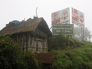
Daulo District is part of the Eastern Highlands Province in Papua New Guinea. It is along the Highlands highway leading to the other Highlands provinces, namely Simbu Province, Western Highlands, Southern Highlands and Enga Province. Daulo District shares geographical border with Simbu Province and Madang Province. Part of Daulo District's Upper Asaro Constituency is a walking distance to Mt. Wilhelm, Papua New Guinea's highest mountain in Simbu Province. Daulo is the real home of the famous Asaro Mudmen. It has a total population of over 53,000 people. It has a small district office administered by the District Administrator who is a representative of the provincial government. The electoral member for Daulo, with the help of the governor for the province, is responsible for the set up and running of Daulo District similarly with the other districts in the Eastern Highlands Province. The district was partly the implementation of the reform initiative undertaken by the Morauta government in 1995.
Ialibu is a small township in the Southern Highlands Province of Papua New Guinea, serving as the headquarters for the Ialibu-Pangia District. It also caters for the Imbongungu speaking people of the Imbonggu Electorate. Ialibu is the transit point into the Kagua-Erave Electorate. The construction route of the Gulf Highway.

The New Guinea Highlands, also known as the Central Range or Central Cordillera, is a long chain of mountain ranges on the island of New Guinea, including the island's tallest peak, Puncak Jaya, Indonesia, 16,024 ft (4,884 m), the highest mountain in Oceania. The range is home to many intermountain river valleys, many of which support thriving agricultural communities. The highlands run generally east-west the length of the island, which is divided politically between Indonesia in the west and Papua New Guinea in the east.

The Chimbu–Wahgi languages are a language family sometimes included in the Trans–New Guinea proposal.
Jimi is a geographical area in the inlands of Papua New Guinea. It is located in the Jimi District of Jiwaka, which was previously a part of the Western Highlands Province until May 2012. It is home to the Jimi Valley. The Jimi District is one of the least developed districts in Papua New Guinea, apart from Green River in Sandaun and Rai Coast in Madang. Its geographical location makes it a remote district of the newly-created Jiwaka province. The district is located in the Jimi Valley, which stretches from the northeast corner of Jiwaka and into Madang Province.
Kerowagi District is one of six districts of the Simbu Province in Papua New Guinea. Its capital is Kerowagi and the district has three Local Level Government (LLG) areas: Gena-Waugla Rural, Kerowagi Rural, and Kup Rural.

Coffee production in Papua New Guinea is the country's second largest agricultural export, after oil palm, and employs approximately 2.5 million people. It accounts for approximately 1% of world production, according to the United Nations Conference on Trade and Development (UNCTAD).
Iambakey Palma Okuk was an independence leader in Papua New Guinea and served as Deputy Prime Minister, the nation's first Minister for Agriculture and Fisheries, and repeatedly in the capacity of Minister of Transport, Minister of Primary Industries and Leader of the Opposition. He is known as Papua New Guinea's "most colourful and controversial politician". Okuk first led protests against unfair labor practices, and then once elected to office, worked to reserve sectors of the economy for citizens as a method of returning a complex economic role to Papua New Guineans. In the post-independence decade, Okuk built a coalition of minority political factions which forced a successful change of government, in which he became Deputy Prime Minister.
Betty Higgins is an entrepreneur from Papua New Guinea (PNG) who developed and runs a trout farm and hotel in the Mount Wilhelm area. In 2009 she was awarded the overall Women in Business Award at the Westpac Outstanding Women Awards for PNG.
