
Goroka is the capital of the Eastern Highlands Province of Papua New Guinea. It is a town of approximately 19,000 people (2000), 1600m above sea level. It has an airport and is on the "Highlands Highway", about 285 km from Lae in Morobe province and 90 km from the nearby town of Kainantu also in the Eastern Highlands. Other nearby towns include Kundiawa in Simbu Province and Mount Hagen in Western Highlands Province. It has a mild climate, known as a "perpetual Spring".

Chimbu, occasionally spelled Simbu, is a province in the Highlands Region of Papua New Guinea. The province has an area of 6,112 km² and a population of 376,473. The capital of the province is Kundiawa. Mount Wilhelm, the tallest mountain in Papua New Guinea, is on the border of Simbu.

Porome, also known as Kibiri, is a Papuan language of southern Papua New Guinea.
The Roman Catholic Archdiocese of Madang is a Metropolitan Archdiocese in Papua New Guinea with suffragan dioceses of Aitape, Lae, Vanimo and Wewak.
The Roman Catholic Archdiocese of Mount Hagen is a Metropolitan Archdiocese in Papua New Guinea. It is responsible for the suffragan dioceses of Goroka, Kundiawa, Mendi and Wabag.
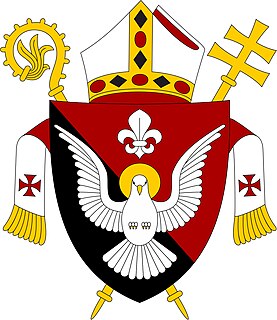
The Roman Catholic Diocese of Kundiawa is a suffragan diocese of the Roman Catholic Archdiocese of Mount Hagen in Papua New Guinea. It was erected in 1982, having been separated from the Diocese of Goroka.
Chimbu Airport is an airport serving Kundiawa, the capital of the Simbu Province in Papua New Guinea.

This page is a list of districts of Papua New Guinea.
Angoram District is a district of East Sepik Province in Papua New Guinea. It is one of the six administrative districts that make up the province. The main town in Angoram.

Kikori District is a district of the Gulf Province of Papua New Guinea. Its capital is Kikori.
Gumine District is a district of the Simbu Province of Papua New Guinea. Its capital is Gumine. The population was 56,860 at the 2011 census. Gumine District comprises of the following major tribes and language groups:
Karimui-Nomane District is a district of the Simbu Province of Papua New Guinea. Its capital is Karimui. The population was 52,159 at the 2011 census.
Imbonggu District is a district of the Southern Highlands Province of Papua New Guinea. Its capital currently is Walume, but previously it was Ialibu Station. The population was 80,994 at the 2011 census.
Jimi District is a district of the Jiwaka Province of Papua New Guinea. Its capital is Tabibuga. The population of the district was 71,379 at the 2011 census. Before May 2012, it was part of the Western Highlands Province. It is home to the Jimi Valley.
Ipiko is a Papuan language of Papua New Guinea, the most divergent of the Inland Gulf languages. Despite being spoken by only a few hundred people, language use is vigorous. It is spoken in Ipiko and Pahemuba villages, with Ipiko village being located in Amipoke ward, Baimuru Rural LLG, Kikori District, Gulf Province.
Mbore a.k.a. Gamei (Gamai) is a Ramu language of Papua New Guinea. It is spoken in Gamei and Boroi villages in Yawar Rural LLG, Bogia District, Madang Province.
Foia Foia (Foyafoya), or Minanibai, is a Papuan language of Papua New Guinea, spoken in an area near Omati River mouth in Ikobi Kairi and Goaribari Census districts.
Gorovu is a nearly extinct Ramu language of Papua New Guinea.
The Lumis is a river of north-western New Ireland, Papua New Guinea. The name was proposed by Stewart and Sandy in 1986.


