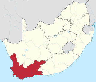
The Western Cape is a province of South Africa, situated on the south-western coast of the country. It is the fourth largest of the nine provinces with an area of 129,449 square kilometres (49,981 sq mi), and the third most populous, with an estimated 7 million inhabitants in 2020. About two-thirds of these inhabitants live in the metropolitan area of Cape Town, which is also the provincial capital. The Western Cape was created in 1994 from part of the former Cape Province, The two largest cities are Cape Town and George.

Ilagan, officially the City of Ilagan, is a 1st class city and capital of the province of Isabela, Philippines. According to the 2015 census, it has a population of 145,568 people making it the most populous city in the province.

Kamwenge District is a district in Western Uganda. It is named after its 'chief town', Kamwenge, where the district headquarters are located. Kamwenge District is part of the Kingdom of Toro, one of the ancient traditional monarchies in Uganda. The kingdom is coterminous with Toro sub-region. The districts that constitute the sub-region are: (a) Bunyangabu District (b) Kabarole District (c) Kamwenge District (d) Kyegegwa District (e) Kitagwenda District and (f) Kyenjojo District.

Chimbu, occasionally spelled Simbu, is a province in the Highlands Region of Papua New Guinea. The province has an area of 6,112 km² and a population of 376,473. The capital of the province is Kundiawa. Mount Wilhelm, the tallest mountain in Papua New Guinea, is on the border of Simbu.

Eastern Highlands is a highlands province of Papua New Guinea. The provincial capital is Goroka. The province covers an area of 11,157 km², and has a population of 579,825. The province shares a common administrative boundary with Madang Province to the north, Morobe Province to the east, Gulf Province to the south, and Simbu Province to the west. The province is the home of the Asaro mud mask that is displayed at shows and festivals within the province and in the country. It is reachable by air and road transport.

Cauayan, officially the City of Cauayan, is a 3rd class component city in the province of Isabela, Philippines. According to the 2015 census, it has a population of 129,523 people.

Cabatuan, officially the Municipality of Cabatuan, is a 2nd class municipality in the province of Iloilo, Philippines. According to the 2015 census, it has a population of 58,442 people.

Northern Province is one of Zambia's ten provinces. It covers approximately one sixth of Zambia in land area. The provincial capital is Kasama. The province is made up of 12 districts, namely Kasama District, Chilubi District, Kaputa District, Luwingu District, Mbala District, Mporokoso District, Mpulungu District, Mungwi District, Nsama District, Lupososhi District, Lunte District and Senga Hill District. Currently, only Kasama and Mbala have attained municipal council status, while the rest are still district councils. It is widely considered to be the heartland of the Bemba, one of the largest tribes in Zambia.

Kundiawa is the capital of Simbu Province, Papua New Guinea, with a population of 8,147. It lies along the Highlands Highway approximately halfway between Goroka and Mount Hagen, respectively the capitals of the Eastern Highlands and Western Highlands provinces.

Al Bahah is a city in the west of Saudi Arabia in the Hejaz area. It is the capital of Al Bahah Region, and is one of the Kingdom's prime tourist attractions. It enjoys a pleasant climate and is surrounded by more than forty forests, including Raghdan, al Zaraeb and Baidan. Al Baha is the headquarters of the Governor, local councils and branches of governmental departments. Receiving the state's special attention, the city of Al Baha abounds in educational, tourist and health institutions. It is considered the capital of the Ghamdi and Zahrani tribes in Saudi Arabia, and most of its inhabitants are from the native tribes.

Embu County is a county of Kenya. The capital of Embu County and the former Eastern province headquarters, Embu is a large and largely metropolitan area with a population of 608,599 persons. The county borders Kirinyaga to the west, Kitui to the east, Tharaka Nithi to the north, Machakos to the south. The county occupies an area of 2,821 km2.

Limbang Division is one of the twelve administrative divisions of Sarawak, Malaysia. It has a total area of 7,788.50 square kilometres, and is the fourth largest division after Kapit Division, Miri Division and Bintulu Division. Limbang Division consists of two districts which are Limbang District and Lawas District, which in turn are divided as sub-districts in Limbang and two sub-districts in Lawas. Long Semadoh and Ba’kelalan are rural settlements in the southern part of Lawas district. Two major towns in Limbang are Limbang and Lawas. There are also few smaller towns such as Sundar, Trusan, Merapok and Tedungan.

Daulo District is part of the Eastern Highlands Province in Papua New Guinea. It is along the Highlands highway leading to the other Highlands provinces, namely Simbu Province, Western Highlands, Southern Highlands and Enga Province. Daulo District shares geographical border with Simbu Province and Madang Province. Part of Daulo District's Upper Asaro Constituency is a walking distance to Mt. Wilhelm, Papua New Guinea's highest mountain in Simbu Province. Daulo is the real home of the famous Asaro Mudmen. It has a total population of over 45,000 people. It has a small district office administered by the District Administrator who is a representative of the provincial government. The electoral member for Daulo, with the help of the governor for the province, is responsible for the set up and running of Daulo District similarly with the other districts in the Eastern Highlands Province. The district was partly the implementation of the reform initiative undertaken by the Morauta government in 1995.

Banakal is a Malnad town in Mudigere Taluk, Chikkamagaluru district of Karnataka, India. This town is situated atop the Charmadi hills in the Western Ghats section. The Western Ghats is one amongst twenty-five identified hot spots for biodiversity conservation in the world. Banakal is surrounded by coffee estates and paddy fields and known for its pleasant weather throughout the year. Banakal town is the headquarters of Banakal Hobli.

Gokwe Centre is a rural small town in the Midlands province in Zimbabwe. The town is usually referred to as "Gokwe Centre" because the larger region is called Gokwe.

Birendranagar is a city in Surkhet District in Karnali province of Nepal.

Ghorahi is the seventh largest city and largest sub-metropolitan city of Nepal. The city lies in Lumbini Province in the mid-Western part of Nepal. It is the largest city of Dang Deukhuri District of southwest Nepal. Located in the Inner Terai region, it lies 413 kilometres (257 mi) south-west of Nepal's capital Kathmandu and is one of the Counter Magnets being developed as an alternative centre of growth to help ease the migration and population explosion in the Kathmandu metropolitan area. It is the largest city of the Rapti Zone and is surrounded by the Sivalik Hills to the south and Mahabharata Range to the north.

Mutasa District is one of seven districts in Manicaland Province of Zimbabwe. Mutasa District is located 30 km northeast Mutare and stretches up to the Honde Valley, which is about 100 km northeast of Mutare along a tarred road that branches off the Nyanga road.
Jimi is a geographical area in the inlands of Papua New Guinea. It is located in the Jimi District of Jiwaka, which was previously a part of the Western Highlands Province until May 2012. It is home to the Jimi Valley. The Jimi District is one of the least developed districts in Papua New Guinea, apart from Green River in Sandaun and Rai Coast in Madang. Its geographical location makes it a remote district of the newly-created Jiwaka province. The district is located in the Jimi Valley, which stretches from the northeast corner of Jiwaka and into Madang Province.

Bhairabi Rural Municipality is a rural municipality located in Dailekh District of Karnali Province of Nepal. The total area of the rural municipality is 110.46 square kilometres (42.65 sq mi) and the total population of the rural municipality as of 2011 Nepal census is 21,233 individuals. The rural municipality is divided into total 7 wards. A small portion of Dullu municipality with Bhairi Kalikathum, Kusapani, Rawalkot and Kasikandh Village development committees were incorporated to form this new rural municipality. The headquarters of the municipality is situated at Bhairi Kalikathum.


