Administrative Union of the Territory of Papua and the Territory of New Guinea | |||||||||||||
---|---|---|---|---|---|---|---|---|---|---|---|---|---|
1949–1975 | |||||||||||||
Anthem: God Save the Queen (1952–1975) O Arise, All You Sons (1975) [1] | |||||||||||||
Status | United Nations Trust Territory (New Guinea) External territory of Australia (Papua) | ||||||||||||
Capital | Port Moresby | ||||||||||||
Common languages | English (official) Austronesian languages Papuan languages English creoles German creoles | ||||||||||||
Demonym(s) | Papua New Guineans, Papuans | ||||||||||||
Monarch | |||||||||||||
• 1949–1952 | George VI | ||||||||||||
• 1952–1975 | Elizabeth II | ||||||||||||
Administrator | |||||||||||||
• 1949–1952 (first) | Jack Keith Murray | ||||||||||||
• 1974–1975 (last) | Tom Critchley | ||||||||||||
Chief Minister | |||||||||||||
• 1972–1975 (last) | Michael Somare | ||||||||||||
Legislature | Legislative Council (1949–1963) House of Assembly (1963–1975) | ||||||||||||
History | |||||||||||||
1 July 1949 | |||||||||||||
• Self-governing | 1 December 1973 | ||||||||||||
16 September 1975 | |||||||||||||
Currency |
| ||||||||||||
|
History of Papua New Guinea |
---|
New Guineaportal |
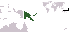
The Territory of Papua and New Guinea, officially the Administrative Union of the Territory of Papua and the Territory of New Guinea, was established by an administrative union between the Australian-administered territories of Papua and New Guinea (the latter being a United Nations trust territory administered by Australia) in 1949. In December 1971, the name of the Territory changed to "Papua New Guinea" and in 1975 it became the Independent State of Papua New Guinea. [2]
Archeological evidence suggests that humans arrived on New Guinea around 50,000 years ago. [3] These Melanesian people developed stone tools and agriculture. Portuguese and Spanish navigators sailing in the South Pacific entered New Guinea waters in the early part of the 16th century and in 1526–27, Jorge de Menezes came upon the principal island "Papua". In 1545, the Spaniard Iñigo Ortiz de Retes gave the island the name "New Guinea" because of what he saw as a resemblance between the islands' inhabitants and those found on the African Guinea coast. Knowledge of the interior of the island remained scant for several centuries after these initial European encounters.
In 1884, Germany formally took possession of the northeast quarter of the island and it became known as German New Guinea. [4] In 1884, a British protectorate was proclaimed over Papua – the southern coast of New Guinea. The protectorate, called British New Guinea, was annexed outright on 4 September 1888 and possession passed to the newly federated Commonwealth of Australia in 1902 and British New Guinea became the Australian Territory of Papua, with Australian administration beginning in 1906. [4]
The Australian Naval and Military Expeditionary Force seized German New Guinea and the neighbouring islands of the Bismarck Archipelago for the Allies in 1914, during the early stages of the First World War. [5] At the 1919 Paris Peace Conference following the war, Australian Prime Minister Billy Hughes sought to secure possession of New Guinea from the defeated German Empire: telling the Conference: "Strategically the northern islands (such as New Guinea) encompass Australia like fortresses. They are as necessary to Australia as water to a city." [6] Article 22 of the Treaty of Versailles provided for the division of Germany and the Central Powers' imperial possessions among the victorious Allies of World War I and German New Guinea, the Bismarck Archipelago and Nauru were assigned to Australia as League of Nations Mandates: territories "formerly governed [by the Central Powers] and which are inhabited by peoples not yet able to stand by themselves under the strenuous conditions of the modern world". [7]
Shortly after the start of the Pacific War, the island of New Guinea was invaded by the Japanese. Most of West Papua, at that time known as Dutch New Guinea, was occupied, as were large parts of the Territory of New Guinea. The New Guinea campaign was a major campaign of the Pacific War. In all, some 200,000 Japanese soldiers, sailors and airmen died during the campaign against approximately 7,000 Australian and 7,000 American service personnel. [8] Major battles included the Battle of Kokoda Trail, Battle of Buna-Gona and Battle of Milne Bay. The offensives in Papua and New Guinea of 1943–44 were the single largest series of connected operations ever mounted by the Australian armed forces. [9] Bitter fighting continued in New Guinea between the Allies and the Japanese 18th Army based in New Guinea until the Japanese surrender in 1945.
Following the Surrender of Japan in 1945, civil administration of Papua and New Guinea was restored, and under the Papua New Guinea Provisional Administration Act (1945–46), Papua and New Guinea were combined in an administrative union. [4] The Papua and New Guinea Act 1949 united, for administrative purposes only, the Territory of Papua and the Territory of New Guinea as the Territory of Papua and New Guinea. The Act formally approved the placing of New Guinea under the international trusteeship system and confirmed the administrative union of New Guinea and Papua under the title of The Territory of Papua and New Guinea. It also provided for a Legislative Council (which was established in 1951), a judicial system, a public service, and a system of local government. [4] The House of Assembly replaced the Legislative Council in 1963, and the first House of Assembly of Papua and New Guinea opened on 8 June 1964.
In 1963, the population was approximately two million, of which about 25,000 were non-indigenous. The economy was based on cash crops including coffee, cocoa, and copra as well as timber mills, wharves and factories. Difficult terrain rendered communication between districts difficult and there was a lack of national unity in the territory. [10]
One of the ways in which the territory was administered was through the use of patrol officers. Between 1949 and 1974, more than 2000 Australians served as patrol officers, known locally as "kiaps". The job of patrol officers involved: facilitating the consolidation of administrative influence, maintaining the rule of law, conducting court cases and presiding as Magistrate, carrying out police work, conducting censuses, encouraging economic development, providing escorts, purchasing land for governmental use and overseeing local elections. [11]
On 13 December 1971 the name of the territory was changed to Papua New Guinea. [2] Under Australian Minister for External Territories Andrew Peacock, the territory adopted self-government in 1972. 1972 elections saw the formation of a ministry headed by Chief Minister Michael Somare, who pledged to lead PNG to self-government and then to independence. [4] Following the passage of the Papua New Guinea Independence Act 1975, during the term of the Whitlam government in Australia, the Territory became the Independent State of Papua New Guinea and attained independence on 16 September 1975. [12] [13]
Papua New Guinea, officially the Independent State of Papua New Guinea, is a country in Oceania that comprises the eastern half of the island of New Guinea and its offshore islands in Melanesia. It shares its only land border with Indonesia to the west and it is directly adjacent to Australia to the south and the Solomon Islands to the east. Its capital, located along its southeastern coast, is Port Moresby. The country is the world's third largest island country, with an area of 462,840 km2 (178,700 sq mi).
The prehistory of Papua New Guinea can be traced to about 50,000–60,000 years ago, when people first migrated towards the Australian continent. The written history began when European navigators first sighted New Guinea in the early part of the 17th century.
Port Moresby, also referred to as Pom City or simply Moresby, is the capital and largest city of Papua New Guinea. It is one of the largest cities in the southwestern Pacific outside of Australia and New Zealand. It is located on the shores of the Gulf of Papua, on the south-western coast of the Papuan Peninsula of the island of New Guinea. The city emerged as a trade centre in the second half of the 19th century. During World War II, it was a prime objective for conquest by the Imperial Japanese forces during 1942–43 as a staging point and air base to cut off Australia from Southeast Asia and the Americas.
German New Guinea consisted of the northeastern part of the island of New Guinea and several nearby island groups and was the first part of the German colonial empire. The mainland part of the territory, called Kaiser-Wilhelmsland, became a German protectorate in 1884. Other island groups were added subsequently. The Bismarck Archipelago, and the North Solomon Islands were declared a German protectorate in 1885. The Caroline Islands, Palau, and the Mariana Islands were bought from Spain in 1899. German New Guinea annexed the formerly separate German Protectorate of Marshall Islands, which also included Nauru, in 1906. German Samoa, though part of the German colonial empire, was not part of German New Guinea.
This is an overview of the postage stamps and postal history of Australia.
The Territory of Papua comprised the southeastern quarter of the island of New Guinea from 1883 to 1975. In 1883, the Government of Queensland annexed this territory for the British Empire. The United Kingdom Government refused to ratify the annexation but in 1884 a protectorate was proclaimed over the territory, then called "British New Guinea". There is a certain ambiguity about the exact date on which the entire territory was annexed by the British. The Papua Act 1905 recites that this happened "on or about" 4 September 1888. On 18 March 1902, the Territory was placed under the authority of the Commonwealth of Australia. Resolutions of acceptance were passed by the Commonwealth Parliament, which accepted the territory under the name of Papua.
Kaiser-Wilhelmsland formed part of German New Guinea, the South Pacific protectorate of the German Empire. Named in honour of Wilhelm I, who reigned as German Emperor from 1871 to 1888, it included the northern part of present-day Papua New Guinea. From 1884 until 1920 the territory was a protectorate of the German Empire. Kaiser-Wilhelmsland, the Bismarck Archipelago, the northern Solomon Islands, the Caroline Islands, Palau, Nauru, the Northern Mariana Islands, and the Marshall Islands comprised German New Guinea.
Morobe Province is a province on the northern coast of Papua New Guinea. The provincial capital and largest city is Lae. The province covers 33,705 km2, with a population of 674,810, and since the division of Southern Highlands Province in May 2012 it is the most populous province. It includes the Huon Peninsula, the Markham River, and delta, and coastal territories along the Huon Gulf. The province has nine administrative districts. At least 101 languages are spoken, including Kâte and Yabem language. English and Tok Pisin are common languages in the urban areas, and in some areas pidgin forms of German are mixed with the native language.
European exploration and settlement of Oceania began in the 16th century, starting with the Spanish (Castilian) landings and shipwrecks in the Mariana Islands, east of the Philippines. This was followed by the Portuguese landing and settling temporarily in some of the Caroline Islands and Papua New Guinea. Several Spanish landings in the Caroline Islands and New Guinea came after. Subsequent rivalry between European colonial powers, trade opportunities and Christian missions drove further European exploration and eventual settlement. After the 17th century Dutch landings in New Zealand and Australia, with no settlement in these lands, the British became the dominant colonial power in the region, establishing settler colonies in what would become Australia and New Zealand, both of which now have majority European-descended populations. States including New Caledonia (Caldoche), Hawaii, French Polynesia, and Norfolk Island also have considerable European populations. Europeans remain a primary ethnic group in much of Oceania, both numerically and economically.
Goodenough Island in the Solomon Sea, also known as Nidula Island, is the westernmost of the three large islands of the D'Entrecasteaux Islands in Milne Bay Province of Papua New Guinea. It lies to the east of mainland New Guinea and southwest of the Trobriand Islands. It is roughly circular in shape, measuring 39 by 26 kilometres with an area of 687 square kilometres (265 sq mi) and a shoreline of 116 kilometres (72 mi). From a coastal belt varying in width from 2 to 10 kilometres in width, the island rises sharply to the summit of Mount Vineuo, 2,536 metres (8,320 ft) above sea level, making it one of the most precipitous islands in the world. The small outlier Wagifa Island lies to the south-east of the island, and is included within Goodenough's administration.
Rambutyo Island is one of the Admiralty Islands in the Bismarck Archipelago. Politically, Rambutyo Island is part of Manus Province, Papua New Guinea. The population (unknown) is concentrated on the west coast. Villages include Mouklen and Lengkau.
The Territory of New Guinea was an Australian-administered League of Nations and then United Nations trust territory on the island of New Guinea from 1914 until 1975. In 1949, the Territory and the Territory of Papua were established in an administrative union by the name of the Territory of Papua and New Guinea. That administrative union was renamed as Papua New Guinea in 1971. Notwithstanding that it was part of an administrative union, the Territory of New Guinea at all times retained a distinct legal status and identity until the advent of the Independent State of Papua New Guinea.
The states and territories are the second level of government of Australia. The states are administrative divisions that are self-governing polities that are partly sovereign, having ceded some sovereign rights to the federal government. They have their own constitutions, legislatures, executive governments, judiciaries and law enforcement agencies that administer and deliver public policies and programs. Territories can be autonomous and administer local policies and programs much like the states in practice, but are still legally subordinate to the federal government.
The history of Australia since 1945 has seen long periods of economic prosperity and the introduction of an expanded and multi-ethnic immigration program, which has coincided with moves away from Britain in political, social and cultural terms and towards increasing engagement with the United States and Asia.
Foreign relations exist between Australia and Papua New Guinea. Papua New Guinea is Australia's closest neighbour and a former colony of Australia. Both nations share the same continent in the Oceania region. Papua New Guinea has developed much closer relations with Australia than with Indonesia, the only country with which it shares a land border. The two countries are Commonwealth realms. In contemporary times, Papua New Guinea is one of the largest recipients of Australian aid. Some critics have pointed to instances where this has led to an outsized Australian influence on Papua New Guinea politics.
The continent of Australia, sometimes known in technical contexts by the names Sahul, Australia-New Guinea, Australinea, or Meganesia to distinguish it from the country of Australia, is located within the Southern and Eastern hemispheres. The continent includes mainland Australia, Tasmania, the island of New Guinea, the Aru Islands, the Ashmore and Cartier Islands, most of the Coral Sea Islands, and some other nearby islands. Situated in the geographical region of Oceania, Australia is the smallest of the seven traditional continents.
The postage stamps and postal history of Papua New Guinea originated in the two colonial administrations on the eastern part of the island of New Guinea and continued until their eventual merger, followed by independence in 1975.
Diplomatic relations exist between Australia and Germany, as well as the historical contacts, shared values of democracy and human rights, substantial commercial links, and a keen interest in each other's culture. As part of a strategic partnership concluded in 2013, both nations are also increasingly cooperating on security policy issues. Both countries also maintain diplomatic relations in each other's countries.
The Allied occupation of German New Guinea was the takeover of the Pacific colony of German New Guinea in September – November 1914 by an expeditionary force from Australia, called the Australian Naval and Military Expeditionary Force.
Papua New Guinean nationality law is regulated by the 1975 Constitution of Papua New Guinea, as amended; the Citizenship Act 1975, and its revisions; and international agreements entered into by the Papua New Guinean government. These laws determine who is, or is eligible to be, a national of Papua New Guinea. The legal means to acquire nationality, formal legal membership in a nation, differ from the domestic relationship of rights and obligations between a national and the nation, known as citizenship. Papua New Guinean nationality is typically obtained either on the principle of jus soli, i.e. by birth in Papua New Guinea or under the rules of jus sanguinis, i.e. by birth abroad to parents with Papua New Guinean nationality. It can be granted to persons who have lived in the country for a specific period of time, who have contributed to the country's development, or who have an affiliation to the country through naturalization.
Prehistorians do not agree how long humans have occupied the Sahul continent (Australia, New Guinea and Tasmania). The figure of 50,000 years used here is a compromise between the shorter time period of about 45,000 years argued by some scholars and the longer one of 50,000–60,000 years argued by others.
{{cite web}}
: CS1 maint: multiple names: authors list (link)