East Deboyne Islands

Last updated
East Deboyne Islands
Deboyne Islands (Landsat).jpg
Papua New Guinea location map.svg
Red pog.svg
East Deboyne Islands
Geography
Location Oceania
Coordinates 10°51′S152°32′E / 10.850°S 152.533°E / -10.850; 152.533 Coordinates: 10°51′S152°32′E / 10.850°S 152.533°E / -10.850; 152.533 [1]
Archipelago Louisiade Archipelago
Adjacent bodies of water Solomon Sea
Total islands8
Major islands
Area1.02 km2 (0.39 sq mi)
Highest elevation37 m (121 ft)
Highest pointMount Pana Sagusagu
Administration
Province Flag of Milne Bay.svg  Milne Bay
District Samarai-Murua District
LLG [2] Louisiade Rural Local Level Government Area
Island Group Deboyne Islands
Largest settlement Redlick Islets
Demographics
Population0 (2014)
Pop. density0/km2 (0/sq mi)
Ethnic groups Papauans, Austronesians, Melanesians.
Additional information
Time zone
ISO code PG-MBA
Official website www.ncdc.gov.pg

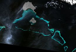
The East Deboyne Islands are a group of scattered island and reefs between the Deboyne Islands and the Renard Islands, in the north of the Louisiade Archipelago, Papua New Guinea. Panaeati Islanders have a Copra plantation on Mabui island.

Contents

Geography

They are located 10 km (6 mi) from Deboyne Islands .

History

The islands were discovered in 1793 by Antoine Bruni d'Entrecasteaux.

Related Research Articles

Papua New Guinea Country in Oceania

Papua New Guinea, officially the Independent State of Papua New Guinea, is a country in Oceania that comprises the eastern half of the island of New Guinea and its offshore islands in Melanesia. Its capital, located along its southeastern coast, is Port Moresby. It is the world's third largest island country with 462,840 km2 (178,700 sq mi).

Gulf of Guinea The northeasternmost part of the tropical Atlantic Ocean from Cape Lopez in Gabon, north and west to Cape Palmas in Liberia

The Gulf of Guinea is the northeasternmost part of the tropical Atlantic Ocean from Cape Lopez in Gabon, north and west to Cape Palmas in Liberia. The intersection of the Equator and Prime Meridian is in the gulf.

Battle of the Coral Sea Major naval battle in the Pacific Theater of World War II

The Battle of the Coral Sea, from 4 to 8 May 1942, was a major naval battle between the Imperial Japanese Navy (IJN) and naval and air forces of the United States and Australia. Taking place in the Pacific Theatre of World War II, the battle is historically significant as the first action in which aircraft carriers engaged each other and the first in which the opposing ships neither sighted nor fired directly upon one another.

Melanesia Subregion of the Pacific Ocean

Melanesia is a subregion of Oceania in the southwestern Pacific Ocean. It extends from the island of New Guinea in the west to Tonga in the east, and includes the Arafura Sea.

Bougainville Island Main island of the Bougainville, Papua New Guinea

Bougainville Island is the main island of the Autonomous Region of Bougainville, which is part of Papua New Guinea. It was previously the main landmass in the German Empire-associated North Solomons. Its land area is 9,300 km2 (3,600 sq mi). The population of the whole province, including nearby islets such as the Carterets, is approximately 300,000. The highest point is Mount Balbi, on the main island, at 2,715 m (8,907 ft). The much-smaller Buka Island, c. 500 km2 (190 sq mi), lies to the north, across the 400–500 m (1,300–1,600 ft) wide Buka Strait. Even though the strait is narrow, there is no bridge across it. But there is a regular ferry service between the key settlements on either side. The main airport in the north is in the town of Buka.

Bismarck Archipelago

The Bismarck Archipelago is a group of islands off the northeastern coast of New Guinea in the western Pacific Ocean and is part of the Islands Region of Papua New Guinea. Its area is about 50,000 square km.

German New Guinea Colonial protectorate 1884–1914

German New Guinea consisted of the northeastern part of the island of New Guinea and several nearby island groups and was the first part of the German colonial empire. The mainland part of the territory, called Kaiser-Wilhelmsland, became a German protectorate in 1884. Other island groups were added subsequently. New Pomerania, the Bismarck Archipelago, and the northern Solomon Islands were declared a German protectorate in 1885; the Caroline Islands, Palau, and the Mariana Islands were bought from Spain in 1899; the protectorate of the Marshall Islands was bought from Spain in 1885 for $4.5 million by the 1885 Hispano-German Protocol of Rome; and Nauru was annexed to the Marshall Islands protectorate in 1888.

Crow Index of animals with the same common name

A crow is a bird of the genus Corvus, or more broadly a synonym for all of Corvus. The word "crow" is used as part of the common name of species including:

States and territories of Australia Overarching divisions of authority in Australia

The states and territories of Australia are the regional governments in Australia, distinct from the federal government and local governments. States are self-administered regions with their own constitutions, legislature, police services, departments, and certain civil authorities, that administer and deliver most public policies and programmes. Territories administer local policies and programmes much like states, but are constitutionally and financially subordinate to the federal government.

A series of raids on Deboyne were conducted by Allied forces against the Imperial Japanese Navy seaplane base in the Deboyne Islands of the Louisiade Archipelago between 9–11 May 1942. The seaplane base had been set up prior to the Battle of Coral Sea and became untenable and was abandoned by the Japanese, due to proximity to Allied airfields at Port Moresby and the failure of Mo Sakusen.

Australia (continent) Continent

The continent of Australia, sometimes known in technical contexts by the names Sahul, Australinea, or Meganesia to distinguish it from the country of Australia, consists of the landmasses which sit on Australia's continental plate. The name "Sahul" takes its name from the Sahul Shelf, which is part of the continental shelf of the Australian continent. The continent includes mainland Australia, Tasmania, and the island of New Guinea. Situated in the geographical region of Oceania, Australia is the smallest of the seven traditional continents.

New Guinea Island in the Pacific Ocean

New Guinea is the world's second-largest island, and with an area of 785,753 km2 (303,381 sq mi), the largest island in the Southern Hemisphere. Located in Melanesia in the southwestern Pacific Ocean, it is separated by the 150 km wide Torres Strait from the Australian continent. Numerous smaller islands are located to the west and east. The eastern half of the island is the major land mass of the independent state of Papua New Guinea. The western half, known as Western New Guinea or West Papua, forms a part of Indonesia and is organized as the provinces of Papua and West Papua.

Deboyne Islands

The Deboyne Islands are an atoll, composed of a group of reefs and islands in the north of the Louisiade Archipelago, Papua New Guinea.

Lunn Island

Lunn Island is a solitary island of Papua New Guinea in the Solomon Sea, belonging to the Louisiade Archipelago. It belongs to Milne Bay Province, to the ward of Conflict Group and is located between the Engineer Group, which is 8.3 kilometres to the west, and the Torlesse Islands, which are 18.3 kilometres to the east. The Deboyne Islands are another 22 kilometres eastward.

Panapompom Islands

Panapompom Island is an island of Papua New Guinea. It is in the Deboyne Islands atoll of the Louisiade Archipelago.

Panaeati Island

Panaeati Island is an island of Papua New Guinea. It is in the Deboyne Islands atoll in the Louisiade Archipelago.

Torlesse Islands

The Torlesse Islands are an archipelago in the Solomon Sea. Politically they belong to Milne Bay Province in the southeastern region of Papua New Guinea. They are 13 km away from Misima and 5 km west of Deboyne Islands. The aggregate land area of the seven islands is 2.08 km². The main village is Tinolan. it is inhabited by a family from Panaeati Island who grow Copra.

Japanese minesweeper <i>Tama Maru</i> (1936) Japanese auxiliary minesweeper

Tama Maru was an auxiliary minesweeper of the Imperial Japanese Navy during World War II.

Japanese minesweeper <i>Wa-1</i> (1942)

Wa-1 was the first No.1-class auxiliary minesweeper of the Imperial Japanese Navy during World War II.

References