
Shifting cultivation is an agricultural system in which plots of land are cultivated temporarily, then abandoned while post-disturbance fallow vegetation is allowed to freely grow while the cultivator moves on to another plot. The period of cultivation is usually terminated when the soil shows signs of exhaustion or, more commonly, when the field is overrun by weeds. The period of time during which the field is cultivated is usually shorter than the period over which the land is allowed to regenerate by lying fallow.
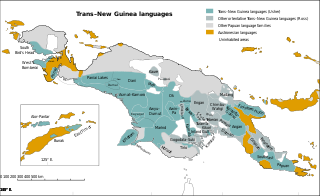
Trans–New Guinea (TNG) is an extensive family of Papuan languages spoken on the island of New Guinea and neighboring islands, a region corresponding to the country Papua New Guinea as well as parts of Indonesia.

Dioscorea alata, also known as purple yam, ube, or greater yam, among many other names, is a species of yam. The tubers are usually a vivid violet-purple to bright lavender in color, but some range in color from cream to plain white. It is sometimes confused with taro and the Okinawa sweet potato, although D. alata is also grown in Okinawa, where it is known as beniimo (紅芋). With its origins in the Asian tropics, D. alata has been known to humans since ancient times.

The Neolithic Revolution, or the (First) Agricultural Revolution, was the wide-scale transition of many human cultures during the Neolithic period from a lifestyle of hunting and gathering to one of agriculture and settlement, making an increasingly large population possible. These settled communities permitted humans to observe and experiment with plants, learning how they grew and developed. This new knowledge led to the domestication of plants into crops.
Kundiawa is the capital of Simbu Province, Papua New Guinea, with a population of 8,147. It lies along the Highlands Highway approximately halfway between Goroka and Mount Hagen, respectively the capitals of the Eastern Highlands and Western Highlands provinces.

Agriculture began independently in different parts of the globe, and included a diverse range of taxa. At least eleven separate regions of the Old and New World were involved as independent centers of origin. The development of agriculture about 12,000 years ago changed the way humans lived. They switched from nomadic hunter-gatherer lifestyles to permanent settlements and farming.

In botany, a berry is a fleshy fruit without a stone (pit) produced from a single flower containing one ovary. Berries so defined include grapes, currants, and tomatoes, as well as cucumbers, eggplants (aubergines) and bananas, but exclude certain fruits that meet the culinary definition of berries, such as strawberries and raspberries. The berry is the most common type of fleshy fruit in which the entire outer layer of the ovary wall ripens into a potentially edible "pericarp". Berries may be formed from one or more carpels from the same flower. The seeds are usually embedded in the fleshy interior of the ovary, but there are some non-fleshy exceptions, such as Capsicum species, with air rather than pulp around their seeds.

Dioscorea esculenta, commonly known as the lesser yam, is a yam species native to Island Southeast Asia and introduced to Near Oceania and East Africa by early Austronesian voyagers. It is grown for their edible tubers, though it has smaller tubers than the more widely-cultivated Dioscorea alata and is usually spiny.

"Las Vegas culture" is the name given to many Archaic settlements which flourished between 8000 BCE and 4600 BCE.(10,000 to 6,600 BP) near the coast of present-day Ecuador. The name comes from the location of the most prominent settlement, Site No. 80, near the Las Vegas River and now within the city of Santa Elena. The Las Vegas culture represents "an early, sedentary adjustment to an ecologically complex coastal environment."

The New Guinea Highlands, also known as the Central Range or Central Cordillera, is a long chain of mountain ranges on the island of New Guinea, including the island's tallest peak, Puncak Jaya, Indonesia, 16,024 ft (4,884 m), the highest mountain in Oceania. The range is home to many intermountain river valleys, many of which support thriving agricultural communities. The highlands run generally east-west the length of the island, which is divided politically between Indonesia in the west and Papua New Guinea in the east.
Deborah M. Pearsall is an American archaeologist who specializes in paleoethnobotany. She maintains an online phytolith database. She is a full professor in the Department of Anthropology at the University of Missouri in Columbia, Missouri, where she first began working in 1978. She received her Ph.D. in anthropology from the University of Illinois at Urbana-Champaign in 1979, with a dissertation titled The Application of Ethnobotanical Techniques to the Problem of Subsistence in the Ecuadorian Formative.

New Guinea is the world's second-largest island, with an area of 785,753 km2 (303,381 sq mi). Located in Melanesia in the southwestern Pacific Ocean, the island is separated from Australia by the 150-kilometre wide Torres Strait, though both landmasses lie on the same continental shelf. Numerous smaller islands are located to the west and east.
Indigenous horticulture is practised in various ways across all inhabited continents. Indigenous refers to the native peoples of a given area and horticulture is the practice of small-scale intercropping.
Agriculture in Papua New Guinea has more than a 7,000 years old history, and developed out of pre-agricultural plant/food collecting and cultivation traditions of local hunter-gatherers. Currently around 85% of Papua New Guinea's population lives from semi-subsistence agriculture. 86% of all food energy consumed in Papua New Guinea is locally sourced.
Munsa is an archaeological site in Uganda, located in the south-eastern part of Bunyoro, and is commonly recognized by a rocky hill known by the locals as "Bikegete", which is enclosed within an earthworks system of ancient ditches. The site is approximately 5 kilometres (3.1 mi) north-west of Kakumiro township in Bugangaizi County, Kakumiro District. "Munsa" is a Runyoro(Lunyoro/Runyoro Edited by Nicholas Aliganyira Nkuuna) name that means "in the trenches". The architects of the earthworks are unknown, although it has been speculated that the site can be linked to the Bachwezi. There is no evidence for this, however, and it seems likely that association of Munsa with the Bachwezi or Chwezi is a recent development.

One of the major human migration events was the maritime settlement of the islands of the Indo-Pacific by the Austronesian peoples, believed to have started from at least 5,500 to 4,000 BP. These migrations were accompanied by a set of domesticated, semi-domesticated, and commensal plants and animals transported via outrigger ships and catamarans that enabled early Austronesians to thrive in the islands of Maritime Southeast Asia, Near Oceania (Melanesia), Remote Oceania, Madagascar, and the Comoros Islands.
Proto-Trans–New Guinea is the reconstructed proto-language ancestral to the Trans–New Guinea languages. Reconstructions have been proposed by Malcolm Ross and Andrew Pawley.

Susan Evelyn Bulmer, known as Sue Bulmer, was a pioneering American archaeologist who worked in Papua New Guinea and New Zealand. She was the first archaeologist to carry out excavations in the New Guinea Highlands in 1959–1960 and 1967–1973.
The Kawelka people are a tribe who live in the Western Highlands Province of Papua New Guinea. The Kawelka are largely based in the immediate area surrounding the Wahgi Valley, located in the New Guinea Highlands. The Kawelka also have historical ties to the Kuk Swamp.

