Tagula Island

Last updated
Vanatinai Island
Nickname: Sudest Island / Tagula Island
Vanatinai, Louisiade Archipelago.jpg
Tagula Island as seen from space. Yeina Island is also visible to the north (top).
Papua New Guinea location map.svg
Red pog.svg
Vanatinai Island
Geography
Location Oceania
Coordinates 11°30′S153°26′E / 11.500°S 153.433°E / -11.500; 153.433 [1]
Archipelago Louisiade Archipelago
Adjacent to Solomon Sea
Total islands1
Major islands
  • Tagula Island
Area830 km2 (320 sq mi)
Length63 km (39.1 mi)
Width13 km (8.1 mi)
Highest elevation806 m (2644 ft)
Highest point Mount Riu
Administration
Province Flag of Milne Bay.svg  Milne Bay
District Samarai-Murua District
LLG [2] Yaleyamba Rural Local Level Government Area
Island Group Vanatinai Islands
Largest settlement Rambuso (pop. ~500)
Demographics
Population3628 (2014)
Pop. density4.37/km2 (11.32/sq mi)
Ethnic groups Papauans, Austronesians, Melanesians
Additional information
Time zone
ISO code PG-MBA
Official website www.ncdc.gov.pg

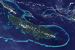
Vanatinai Island (also called Tagula and Sudest, for the names of the extreme capes of the island) is a volcanic island in the southeast of the Louisiade Archipelago within Milne Bay Province of Papua New Guinea. The reef-fringed island is approximately 360 kilometres (224 miles) southeast of New Guinea and 30 kilometres (19 miles) south of Misima. With an area of 830 square kilometres (320.5 square miles), it is the largest island of the archipelago. Tagula town, the main settlement, is located on the northwest coast. The population was 3,628 as of 2014. The principal export is copra.

Contents

Geography

The island is 63 kilometres (39 miles) long, stretching from Cape Tagula to Cape Sudest, and up to 13 km (8.1 miles) wide. A wooded mountain range runs through the length of the island, with the summit, Mount Riu (806 metres or 2,644 feet) near the center. The most important peaks of the range are, from west to east:

Climate

Most of Tagula island has a tropical rainforest climate (Af) but the main settlement of Tagula, located in the northernmost and driest part of the island, has a tropical monsoon climate (Am).

Climate data for Tagula town
MonthJanFebMarAprMayJunJulAugSepOctNovDecYear
Mean daily maximum °C (°F)31.0
(87.8)
31.3
(88.3)
30.8
(87.4)
29.4
(84.9)
28.8
(83.8)
28.0
(82.4)
27.9
(82.2)
27.8
(82.0)
28.6
(83.5)
29.9
(85.8)
30.6
(87.1)
31.3
(88.3)
29.6
(85.3)
Daily mean °C (°F)27.2
(81.0)
27.4
(81.3)
27.2
(81.0)
26.4
(79.5)
26.1
(79.0)
25.5
(77.9)
25.5
(77.9)
25.3
(77.5)
26.0
(78.8)
26.8
(80.2)
27.1
(80.8)
27.5
(81.5)
26.5
(79.7)
Mean daily minimum °C (°F)23.4
(74.1)
23.6
(74.5)
23.6
(74.5)
23.5
(74.3)
23.4
(74.1)
23.1
(73.6)
23.1
(73.6)
22.9
(73.2)
23.4
(74.1)
23.8
(74.8)
23.7
(74.7)
23.8
(74.8)
23.4
(74.2)
Average precipitation mm (inches)215
(8.5)
249
(9.8)
218
(8.6)
217
(8.5)
138
(5.4)
60
(2.4)
71
(2.8)
52
(2.0)
88
(3.5)
106
(4.2)
112
(4.4)
170
(6.7)
1,696
(66.8)
Source: Climate-Data.org [3]

History

The first recorded sighting by Europeans of Vanatinai Island was by the Spanish expedition of Luís Vaez de Torres on 14 July 1606. [4] [5] [6]

The island was the site of a gold rush that began in 1888 and peaked in 1889. Gold was found in nearly all of the island's water courses. [7]

Rambuso Village is located on the north coast of the eastern part of the island, where Rambuso Creek flows into the Pacific Ocean. Entry through the reef to the harbour is deep and easy to see during daylight. Many visiting yachts and local trading boats use this protected anchorage. In 2010 the villagers and several visiting yachties rebuilt the wharf and causeway. The villagers new slogan is "Rambuso Creek the gateway to Sudest". The new wharf helped Rambuso develop and now the busy town has some 500 citizens.

Transportation

The island has an airport, code (IATA-Code „TGL“) for public transport, near Tagula village.

Biodiversity

Several species are endemic to the island, including the aptly named Tagula white-eye, Tagula honeyeater and Tagula butcherbird. Among frogs, Cophixalus tagulensis is only known from Tagula. [8]

Related Research Articles

<span class="mw-page-title-main">Louisiade Archipelago</span> Archipelago of Papua New Guinea

The Louisiade Archipelago is a string of ten larger volcanic islands frequently fringed by coral reefs, and 90 smaller coral islands in Papua New Guinea.

<span class="mw-page-title-main">Torres Strait Islands</span> Group of islands in the Torres Strait between Australia and New Guinea

The Torres Strait Islands are an archipelago of at least 274 small islands in the Torres Strait, a waterway separating far northern continental Australia's Cape York Peninsula and the island of New Guinea. They span an area of 48,000 km2 (19,000 sq mi), but their total land area is 566 km2 (219 sq mi).

<span class="mw-page-title-main">Milne Bay Province</span> Place in Papua New Guinea

Milne Bay is a province of Papua New Guinea. Its capital is Alotau. The province covers 14,345 km² of land and 252,990 km² of sea, within the province there are more than 600 islands, about 160 of which are inhabited. The province has about 276,000 inhabitants, speaking about 48 languages, most of which belong to the Eastern Malayo-Polynesian branch of the Austronesian language family. Economically the province is dependent upon tourism, oil palm, and gold mining on Misima Island; in addition to these larger industries there are many small-scale village projects in cocoa and copra cultivation. The World War II Battle of Milne Bay took place in the province.

<span class="mw-page-title-main">Misima Island</span>

Misima is a volcanic island in the northwest of Louisiade Archipelago within Milne Bay Province of Papua New Guinea.

<span class="mw-page-title-main">Taveuni</span> Island in Fiji

Taveuni is the third-largest island in Fiji, after Viti Levu and Vanua Levu, with a total land area of 434 square kilometres. The cigar-shaped island, a massive shield volcano which rises from the floor of the Pacific Ocean, is situated 6.5 kilometres east of Vanua Levu, across the Somosomo Strait. It belongs to the Vanua Levu Group of islands and is part of Fiji's Cakaudrove Province within the Northern Division.

<span class="mw-page-title-main">Solomon Sea</span> A sea in the Pacific Ocean between Papua New Guinea and Solomon Islands

The Solomon Sea is a sea located within the Pacific Ocean. It lies between Papua New Guinea and Solomon Islands. Many major battles were fought there during World War II.

<span class="mw-page-title-main">Far North Queensland</span> Region in Queensland, Australia

Far North Queensland (FNQ) is the northernmost part of the Australian state of Queensland. Its largest city is Cairns and it is dominated geographically by Cape York Peninsula, which stretches north to the Torres Strait, and west to the Gulf Country. The waters of Torres Strait include the only international border in the area contiguous with the Australian mainland, between Australia and Papua New Guinea.

<span class="mw-page-title-main">Rossel Island</span> Island in Papua New Guinea

Rossel Island is the easternmost island of the Louisiade Archipelago, within the Milne Bay Province of Papua New Guinea. Tree Islet is situated 1.5 miles to the north-west, while Wule Island is situated 1.5 miles westward.

Barygenys exsul is a species of frog in the family Microhylidae. It is endemic to Papua New Guinea. It is known from Rossel and Sudest Islands in the Louisiade Archipelago, east of New Guinea. It is uncertain whether the specimens from Sudest really are conspecific with this species. Barygenys apodasta and Barygenys resima were mixed with this species prior to their description in 2013.

Cophixalus tagulensis is a species of frog in the family Microhylidae. It is endemic to Papua New Guinea and only known from the Tagula Island in the Louisiade Archipelago, east of New Guinea. It is only known from the type series of three specimens collected in 1956.

<span class="mw-page-title-main">Panniet naked-backed fruit bat</span> Species of bat

The Panniet naked-backed fruit bat, also known as the De Vis's Bare-backed Fruit Bat and Panaeati Bare-backed Fruit Bat, is a species of megabat in the family Pteropodidae. It roosts in groups, within caves and tree hollows.

<span class="mw-page-title-main">Central Indo-Pacific</span> Biogeographic sea region

The Central Indo-Pacific is a biogeographic region of Earth's seas, comprising the tropical waters of the western Pacific Ocean, the eastern Indian Ocean, and the connecting seas.

<span class="mw-page-title-main">Hiw (island)</span> Northernmost island in Vanuatu

Hiw is the northernmost island in Vanuatu, located in Torba Province.

<span class="mw-page-title-main">Bramble Cay</span> Island in Queensland, Australia

Bramble Cay, also known as Maizab Kaur and Massaramcoer, is a small cay located at the northeastern edge of Australia and the Torres Strait Islands of Queensland and at the northern end of the Great Barrier Reef. Lying around 50 km (31 mi) north of Erub Island in the Gulf of Papua, it is the northernmost point of land of Australia and marks the end of the Great Barrier Reef.

<span class="mw-page-title-main">Solomon Islands (archipelago)</span> Archipelago in the South Pacific spreading over two countries

The Solomon Islands (archipelago) is an island group in the western South Pacific Ocean, north-east of Australia. The archipelago is in the Melanesian subregion and bioregion of Oceania and forms the eastern boundary of the Solomon Sea. The many islands of the archipelago are distributed across Papua New Guinea and Solomon Islands (country). The largest island in the archipelago is Bougainville Island, which is a part of the Autonomous Region of Bougainville along with Buka Island, the Nukumanu Islands, and a number of smaller nearby islands. Much of the remainder falls within the territory of Solomon Islands and include the atolls of Ontong Java, Sikaiana, the raised coral atolls of Bellona and Rennell, and the volcanic islands of Choiseul, Guadalcanal, Makira, Malaita, New Georgia, the Nggelas, Santa Isabel, and the Shortlands. The Santa Cruz Islands are not a part of the archipelago.

<span class="mw-page-title-main">Duchateau Islands</span>

The Duchateau Islands are an island group in the Coral Sea, belonging to Papua New Guinea. They lie to the east of Panarairai Island in the Louisiade Archipelago.

The Calvados Chain are a group of islands in the Solomon Sea, belonging to Papua New Guinea within the Louisiade Archipelago.

<span class="mw-page-title-main">Duperre Islands</span>

Bramble Haven is an atoll in the Louisiade Archipelago. Its islands on the northern section are grouped as the Duperre Islands.

<span class="mw-page-title-main">Samarai Islands</span> Archipelago in Papua New Guinea

The Samarai Islands archipelago, part of the larger Louisiade Archipelago, is located 50 kilometres (31 mi) southeast of mainland New Guinea island, within the nation of Papua New Guinea.

References

  1. Prostar Sailing Directions 2004 New Guinea Enroute, p. 168
  2. LLG map Archived 2010-08-11 at the Wayback Machine
  3. "Climate: Tagula". Climate-Data.org. Retrieved 16 October 2020.
  4. Hilder, Brett The voyage of Torres, Brisbane, 1980, pp.XXIV,24
  5. Sharp, Andrew The discovery of the Pacific Islands Oxford, 1960, p.66.
  6. Brand, Donald D. The Pacific Basin: A History of its Geographical Explorations The American Geographical Society, New York, 1967, p.137.
  7. Pacific Islands Yearbook, 13th ed., Sydney, New York 1972
  8. Frost, Darrel R. (2016). "Cophixalus tagulensis Zweifel, 1963". Amphibian Species of the World: an Online Reference. Version 6.0. American Museum of Natural History. Retrieved 11 February 2017.