
New Britain is the largest island in the Bismarck Archipelago, part of the Islands Region of Papua New Guinea. It is separated from New Guinea by a northwest corner of the Solomon Sea and from New Ireland by St. George's Channel. The main towns of New Britain are Rabaul/Kokopo and Kimbe. The island is roughly the size of Taiwan. While the island was part of German New Guinea, it was named Neupommern . In common with most of the Bismarcks it was largely formed by volcanic processes, and has active volcanoes including Ulawun, Langila, the Garbuna Group, the Sulu Range, and the volcanoes Tavurvur and Vulcan of the Rabaul caldera. A major eruption of Tavurvur in 1994 destroyed the East New Britain provincial capital of Rabaul. Most of the town still lies under metres of ash, and the capital has been moved to nearby Kokopo.

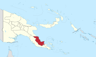
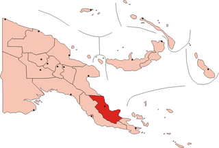
Milne Bay is a province of Papua New Guinea. Its capital is Alotau. The province covers 14,345 km² of land and 252,990 km² of sea, within the province there are more than 600 islands, about 160 of which are inhabited. The province has about 276,000 inhabitants, speaking about 48 languages, most of which belong to the Eastern Malayo-Polynesian branch of the Austronesian language family. Economically the province is dependent upon tourism, oil palm, and gold mining on Misima Island; in addition to these larger industries there are many small-scale village projects in cocoa and copra cultivation. The World War II Battle of Milne Bay took place in the province.
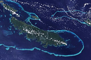
Vanatinai Island is a volcanic island in the south-east of the Louisiade Archipelago within Milne Bay Province of Papua New Guinea. The reef-fringed island is approximately 360 kilometres south-east of New Guinea and 30 kilometres south of Misima. With an area of 830 square kilometres, it is the largest island of the archipelago. Tagula town, the main settlement, is located on the north-west coast. The population was 3628 as of 2014. The principal export is copra.
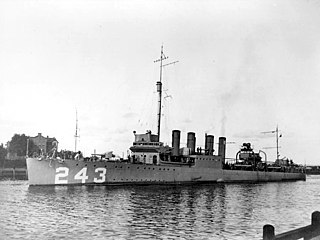
The first USS Sands (DD-243/APD-13) was a Clemson-class destroyer in the United States Navy during World War II. She was the first ship named for Benjamin F. Sands and his son, James H. Sands.

Milne Bay is a large bay in Milne Bay Province, south-eastern Papua New Guinea. More than 35 kilometres long and over 15 kilometres wide, Milne Bay is a sheltered deep-water harbor accessible via Ward Hunt Strait. It is surrounded by the heavily wooded Stirling Range to the north and south, and on the northern shore, a narrow coastal strip, soggy with sago and mangrove swamps. The bay is named after Sir Alexander Milne.
Oro Province, formerly Northern Province, is a coastal province of Papua New Guinea. The provincial capital is Popondetta. The province covers 22,800 km2, and has 176,206 inhabitants. The province shares land borders with Morobe Province to the northwest, Central Province to the west and south, and Milne Bay Province to the southeast. The province is located within the Papuan Peninsula.

Goodenough Island in the Solomon Sea, also known as Nidula Island, is the westernmost of the three large islands of the D'Entrecasteaux Islands in Milne Bay Province of Papua New Guinea. It lies to the east of mainland New Guinea and southwest of the Trobriand Islands. It is roughly circular in shape, measuring 39 by 26 kilometres with an area of 687 square kilometres (265 sq mi) and a shoreline of 116 kilometres (72 mi). From a coastal belt varying in width from 2 to 10 kilometres in width, the island rises sharply to the summit of Mount Vineuo, 2,536 metres (8,320 ft) above sea level, making it one of the most precipitous islands in the world. The small outlier Wagifa Island lies to the south-east of the island, and is included within Goodenough's administration.

The New Guinea campaign of the Pacific War lasted from January 1942 until the end of the war in August 1945. During the initial phase in early 1942, the Empire of Japan invaded the Territory of New Guinea on 23 January and Territory of Papua on 21 July and overran western New Guinea beginning on 29 March. During the second phase, lasting from late 1942 until the Japanese surrender, the Allies—consisting primarily of Australian forces—cleared the Japanese first from Papua, then New Guinea, and finally from the Dutch colony.
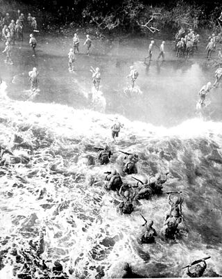
The Battle of Cape Gloucester was fought in the Pacific theater of World War II between Japanese and Allied forces on the island of New Britain, Territory of New Guinea, between 26 December 1943 and 16 January 1944. Codenamed Operation Backhander, the US landing formed part of the wider Operation Cartwheel, the main Allied strategy in the South West Pacific Area and Pacific Ocean Areas during 1943–1944. It was the second landing the US 1st Marine Division had conducted during the war thus far, after Guadalcanal. The objective of the operation was to capture the two Japanese airfields near Cape Gloucester that were defended by elements of the Japanese 17th Division.
Oro Bay is a bay in Oro Province, Papua New Guinea, located 15 miles (24 km) southeast of Buna. The bay is located within the larger Dyke Ackland Bay. A port is operated by PNG Ports Corporation Limited with limited wharf facilities, located at 8°53′47″S148°29′39″E.

Oro Bay Airfield is a former World War II airfield in Oro Province, Papua New Guinea. The airfield was abandoned after the war and today is almost totally returned to its natural state.
Sanananda is a village on the coast of Oro Province, Papua New Guinea.
HMAS Ladava is a former Royal Australian Navy (RAN) base that was located at Milne Bay in Papua New Guinea.
Cape Nelson is a cape on the north coast of Oro Province, Papua New Guinea. The cape was named by Captain John Moresby in 1874 commanding HMS Basilisk after Lord Horatio Nelson.
HMAS Paluma was a survey vessel that was operated by the Royal Australian Navy during World War II.
Aloha State built by Western Pipe and Steel Company, San Francisco, as Sea Snipe for the United States Maritime Commission as a standard Type C3-S-A2 transport ship. The ship was one of the first of the standard vessels modified into a troop transport. Sea Snipe was completed 29 May 1943 and delivered to the War Shipping Administration (WSA) upon completion. American President Lines operated the ship throughout the war under a WSA agreement. The ship, after brief charter to the British Ministry of War Transport in 1946 and lay up in 1947 served as a civilian transport ship for 24 years, first as Edward Luckenbach for Luckenbach Steamship Company then Aloha State for States Marine Lines. The ship was scrapped in August 1971.

USS LST-22 was a United States Navy LST-1-class tank landing ship used exclusively in the Asiatic-Pacific Theater during World War II and staffed by a United States Coast Guard crew. Like many of her class, she was not named and is properly referred to by her hull designation.
Naval Base Milne Bay, also called Naval Advance Base Milne Bay, was new major United States Navy sea and airbase base built on Milne Bay in Milne Bay Province in south-eastern Papua New Guinea. By spring 1943, the build up of the US Navy to support the Pacific War had caused overcrowding at the ports on the east coast of Australia. To help, Seabees departed Naval Base Brisbane on June 19, 1943 to set up a new base in Milne Bay. Naval Base Milne Bay headquarters was at Ladava Navy Base. The Royal Australian Navy already had a small base in Milne Bay: HMAS Ladava. Australians were able to defend and keep Milne Bay in the Battle of Milne Bay in 1942. Naval Base Milne Bay was built during World War II to support the many ships and aircraft fighting and patrolling in the South West Pacific theatre of war. Ladava Navy Base provided a large protective US Navy fleet anchorage at Gahora Bay next to Ladava. At Naval Base Milne Bay, Seabees built a large Naval facility.

US Naval Base New Guinea was number of United States Navy bases on the island of New Guinea during World War II. Australia entered World War II on 3 September 1939, being a self-governing nation within the British Empire. The United States formally entered the war on 7 December 1941, following the attack on Pearl Harbor by the Empire of Japan. Following the attack on Pearl Harbor, Japan quickly took over much of the South Pacific Ocean. The United States lost key naval bases in the South Pacific, including Naval Base Manila and Naval Base Subic Bay, both lost in the 1941–42 invasion of the Philippines. Also lost were Naval Base Guam and Wake Atoll. As such, the United States Armed Forces needed new bases in the South West Pacific for staging attacks on Japan's southern empire. The United States built bases first in Australia, then in New Guinea.
