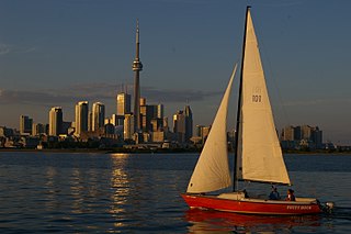
Toronto Harbour or Toronto Bay is a bay on the north shore of Lake Ontario, in Toronto, Ontario, Canada. It is a natural harbour, protected from Lake Ontario waves by the Toronto Islands. Today, the harbour is used primarily for recreational boating, including personal vessels and pleasure boats providing scenic or party cruises. Ferries travel from docks on the mainland to the Islands, and cargo ships deliver aggregates and raw sugar to industries located in the harbour. Historically, the harbour has been used for military vessels, passenger traffic and cargo traffic. Waterfront uses include residential, recreational, cultural, commercial and industrial sites.

Kokoda is a station town in the Oro Province of Papua New Guinea. It is famous as the northern end of the Kokoda Track, site of the eponymous Kokoda Track campaign of World War II. In that campaign, it had strategic significance because it had the only airfield along the Track. In the decades preceding, it had been a foothills settlement near the gold fields.
Kamarajar Port Limited, formerly Ennore Port, is located on the Coromandel Coast about 18 km north of Chennai Port, Chennai, it is the 12th major port of India, and the first port in India which is a public company. The Kamarajar Port Limited is the only corporatised major port and is registered as a company. Chennai Port Trust acquired around 67% stake of Centre in the Kamarajar Port Limited on 27 March 2020. The remaining 23 percent was held by the Chennai Port Trust. The port has been able to attract an investment of ₹ 26,000 million by private entrepreneurs on various terminals and harbour craft. Kamarajar Port Limited, designed as Asia's energy port, is the first corporatised port in India and has only 86 employees. Envisaged being a satellite port to decongest and improve the environmental quality at the bustling Chennai Port, Kamarajar Port Limited is evolving itself into a full-fledged port with the capacity to handle a wide range of products. With a permissible draught of 13.5 m, the port handled a total volume of 11.01 million tonnes in 2010–11, up by 2.86 per cent from the previous year.

Halifax Harbour is a large natural harbour on the Atlantic coast of Nova Scotia, Canada, located in the Halifax Regional Municipality.

The Ok Tedi Mine is an open-pit copper and gold mine in Papua New Guinea located near the headwaters of the Ok Tedi River, in the Star Mountains Rural LLG of the North Fly District of the Western Province of Papua New Guinea.

The New Guinea campaign of the Pacific War lasted from January 1942 until the end of the war in August 1945. During the initial phase in early 1942, the Empire of Japan invaded the Australian-administered Mandated Territory of New Guinea and the Australian Territory of Papua and overran western New Guinea, which was a part of the Netherlands East Indies. During the second phase, lasting from late 1942 until the Japanese surrender, the Allies—consisting primarily of Australian forces—cleared the Japanese first from Papua, then the Mandate and finally from the Dutch colony.

The Port of Karachi is one of South Asia's largest and busiest deep-water seaports, handling about 60% of the nation's cargo located in Karachi, Pakistan. It is located on the Karachi Harbour, between Kiamari, Manora, and Kakapir, and close to Karachi's main business district and several industrial areas. The geographic position of the port places it in close proximity to major shipping routes such as the Strait of Hormuz. The administration of the port is carried out by the Karachi Port Trust, which was established in 1857.
International Container Terminal Services, Inc. (ICTSI) is a global port management company headquartered in Manila, Philippines. Established December 24, 1987, ICTSI is the Philippines' largest multinational and transnational company, having established operations in both developed and emerging market economies in Asia Pacific, the Americas, and Europe, the Middle East and Africa. The company is ranked the eighth largest container terminal operator, according to TEU equity volume.

HMAS Warrego (L73/U73), named for the Warrego River, was a Grimsby class sloop of the Royal Australian Navy (RAN).

Ports of Auckland Limited (POAL), the successor to the Auckland Harbour Board, is the Auckland Council-owned company administering Auckland's commercial freight and cruise ship harbour facilities. As the company operates all of the associated facilities in the Greater Auckland area, this article is about both the current company and the ports of Auckland themselves.

USS Rigel (AD-13/ARb-1/AR-11) was an Altair class destroyer tender named for Rigel, the brightest star in the constellation Orion.
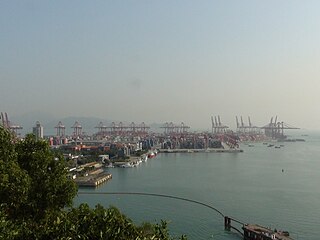
The Port of Shenzhen is a collective name of a number of ports along parts of the coastline of Shenzhen, Guangdong Province, China. These ports as a whole forms one of the busiest and fastest growing container ports in the world.
The Port of Tauranga is situated in Tauranga, New Zealand. It is the largest port in the country both in terms of total cargo volume, and in terms of container throughput with container volumes exceeding 950,000 TEUs. The port is operated by Port of Tauranga Ltd. This article is about both the company and the port itself.

The Port of Geelong is located on the shores of Corio Bay at Geelong, Victoria, Australia. The port is the sixth-largest in Australia by tonnage.
The Port of Eden is a small seaport situated in Twofold Bay, adjacent to the town of Eden, located in the South Coast region of New South Wales, Australia.
Tufi is a town located on the south eastern peninsula of Cape Nelson, Oro Province, Papua New Guinea. Tufi is located on one of many rias, or drowned river valleys, locally referred to as 'fjords', on Cape Nelson surrounded by many uncharted reefs. The area is also famous for its production of tapa cloth.

SS Bantam was built by N.V. Machinefabriek & Scheepswerf van P. Smit Jr. of Rotterdam, Netherlands in 1930 of 3322 gross weight and operated by Koninklijke Paketvaart-Maatschappij. Bantam, under charter, became a part of the initial United States Army local fleet in Australia, was severely damaged 28 March 1943 in New Guinea and eventually scuttled off Sydney.

Operation Lilliput was the name given to a convoy operation directed by G.H.Q. Operations Instructions Number 21 of 20 October 1942 for transportation of troops, weapons, and supplies in a regular transport service between Milne Bay and Oro Bay, New Guinea between 18 December 1942 and June 1943 in order "to cover reinforcement, supply, and development of the Buna-Gona area upon its anticipated capture" by the Australian 7th Division and the United States Army's 32d Division. Within six months, the convoys, escorted by Royal Australian Navy corvettes and largely composed of Dutch KPM merchant ships, had delivered 60,000 tons of supplies and 3,802 troops from Milne Bay to Oro Bay. Corvettes provided the majority of the escort force. Losses during Imperial Japanese air attacks amounted to two merchant ships, 's Jacob and Van Heemskerk, sunk and two badly damaged while several of the corvettes also sustained damage and casualties.

SS Van Heemskerk was a freighter built by N.V. Nederlandsche Scheepsbouw-Maatschappij with engines built by Nederlandsche Fabriek van Werktuigen & Spoorwegmaterieel N.V, both of Amsterdam, Netherlands. The ship of 2,996 GRT was launched 31 August 1909 and delivered 29 October 1909 for operation by Koninklijke Paketvaart-Maatschappij (KPM) in the Dutch East Indies trade.

The Port Authority of New South Wales, is a corporation owned by the State Government of New South Wales, Australia. The Port Authority acts as harbourmaster at the State's six commercial seaports, managing shipping movements, safety, security and emergency response. While major cargo handling facilities are operated by the private sector, the Port Authority continues to manage smaller facilities including Sydney's two cruise terminals, at Circular Quay and White Bay; common user berths at Sydney's Glebe Island and White Bay; and the regional ports at Eden and Yamba.

