
The Coral Sea Islands Territory is an external territory of Australia which comprises a group of small and mostly uninhabited tropical islands and reefs in the Coral Sea, north-east of Queensland, Australia. The only inhabited island is Willis Island. The territory covers 780,000 km2 (301,160 sq mi), most of which is ocean, extending east and south from the outer edge of the Great Barrier Reef and includes Heralds Beacon Island, Osprey Reef, the Willis Group and fifteen other reef/island groups. Cato Island is the highest point in the Territory.
Three Islands and Three Islands Reef are part of the Three Islands Group National Park in Far North Queensland, Australia, in the Coral Sea, 1,581 km (982 mi) northwest of Brisbane, about 44 km (27 mi) north-northeast of Cooktown.

Pemba Island is a Tanzanian island forming part of the Zanzibar Archipelago, lying within the Swahili Coast in the Indian Ocean.

An islet is generally a small island. Definitions vary, and are not precise, but some suggest that an islet is a very small, often unnamed, island with little or no vegetation to support human habitation. It may be made of rock, sand and/or hard coral; may be permanent or tidal ; and may exist in the sea, lakes, rivers or any other sizeable bodies of water.
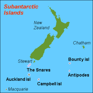
The New Zealand Subantarctic Islands comprise the five southernmost groups of the New Zealand outlying islands. They are collectively designated as a UNESCO World Heritage Site.

Boundary Islet, historically known as North East Islet, is a 2-hectare (4.9-acre) islet in the Hogan Island Group of Bass Strait, at a latitude of 39°12′ S, about 56 kilometres (35 mi) east of the southernmost point of mainland Victoria. The islet straddles the maritime border of the Australian states of Victoria and Tasmania, hence the name.
The Hunter Island, the main island of the Hunter Island Group, is a 7,330-hectare (18,100-acre) island, located in Bass Strait, that lies between King Island and north-west Tasmania, Australia.

The Liancourt Rocks, also known by their Korean name of Dokdo or their Japanese name of Takeshima, are a group of islets in the Sea of Japan between the Korean peninsula and the Japanese archipelago administered by South Korea. The Liancourt Rocks comprise two main islets and 35 smaller rocks; the total surface area of the islets is 0.187554 square kilometres and the highest elevation of 168.5 metres (553 ft) is on the West Islet. The Liancourt Rocks lie in rich fishing grounds that may contain large deposits of natural gas. The English name Liancourt Rocks is derived from Le Liancourt, the name of a French whaling ship that came close to being wrecked on the rocks in 1849.

The Nuggets is a close group of four granite islets, with a combined area of 6.76 hectares, in south-eastern Australia. They lie close to the eastern coast of Tasmania near the Freycinet Peninsula., and are near Cape Tourville, about 7 km north of Wineglass Bay and about 22 km north of Schouten Island.

Busby Islet Conservation Park is a protected area located on Busby Islet in Nepean Bay on the north coast of Kangaroo Island in South Australia. The conservation park is located about 2 kilometres north of the town of Kingscote and occupies an area of 17 hectares on Busby Islet. It was dedicated in 1967 for 'the conservation of wildlife habitat' replacing previous statutory protection dating back to 1909. A management philosophy for the park published in 1987 supports the need to 'ensure the conservation, in perpetuity, of the natural environment, in particular the breeding habitat for birds of the ocean and seashore'. The conservation park is reported as supporting breeding populations of Australian pelicans, black-faced and pied cormorants, pied and sooty oystercatchers, and silver and Pacific gulls, serving as a roost site for migratory waders and being a place visited by Rock parrots and little grassbirds. The conservation park was declared as a 'no entry' area in October 2014. The conservation park is classified as an IUCN Category Ia protected area.
Liivanuka ots is an Estonian islet with surface area of 0.0059 hectares. It is a sandy, oval-shaped islet, stretching in a north-south direction. It lies southeast of the island of Hiiumaa in the Jausa rand, next to the islet of Hanerahu. Liivanuka ots is part of Hiiumaa Parish, Hiiu County. The islet belongs to Hiiumaa Islets Landscape Reserve.

The Casuarina Islets, also known as The Brothers, is a pair of islands located in the Great Australian Bight immediately off the south-west coast of Kangaroo Island in South Australia approximately 96 kilometres south-west of Kingscote. The pair is currently part of the Flinders Chase National Park.
Baudin Rocks, also previously known as the Godfrey Islands, is a group of islets on the south east coast of in the Australian state of South Australia about 8.3 kilometres North-northwest of Robe. The islet group was discovered and named by Matthew Flinders in 1802 after Nicolas Baudin. The group has had protected area status since 1965 and since 1972, the group has been part of the Baudin Rocks Conservation Park.
Beatrice Islets are pair of islets in the Australian state of South Australia located in Nepean Bay on the north coast of Kangaroo Island about 4 kilometres east of Kingscote. The islets and adjoining intertidal areas are notable as habitat for bird life. The islet pair has enjoyed protected area status since 1909 and since at least 1972, have been part of the Beatrice Islet Conservation Park. During either the 1960s or the 1970s, the islets were extensively damaged by an exercise to remove an infestation of South African boxthorn.
Busby Islet is an islet in the Australian state of South Australia located in Nepean Bay on the north coast of Kangaroo Island about 2 kilometres north of the municipal seat of Kingscote. The islet and adjoining areas are notable as habitat for bird life. The islet has enjoyed protected area status since 1909 and since at least 1972, have been part of the Busby Islet Conservation Park.
Güvercin Islet is a Mediterranean islet of Turkey. It is a part of Silifke ilçe (district) of Mersin Province. It is at 36°14′38″N33°48′38″E and situated about 200 metres (660 ft) to main land. The islet is quite small; only 3,000 square metres (32,000 sq ft). There are ruins of late Roman Empire era in this otherwise unnotable island. The ruins are in the north east side of the island. The ruins probably belonged to a mansion. The construction material is rectangular stone. There are tombs, ceramics and a part of a mosaic floor in the island.

