
Sulawesi, also known as Celebes, is an island in Indonesia. One of the four Greater Sunda Islands, and the world's eleventh-largest island, it is situated east of Borneo, west of the Maluku Islands, and south of Mindanao and the Sulu Archipelago. Within Indonesia, only Sumatra, Borneo, and Papua are larger in territory, and only Java and Sumatra have larger populations.

Central Sulawesi is a province of Indonesia located at the centre of the island of Sulawesi. The administrative capital and largest city is located in Palu. The 2010 census recorded a population of 2,635,009 for the province, and the 2020 Census recorded 2,985,734, of whom 1,534,706 were male and 1,451,028 were female. The official estimate as at mid 2021 was 3,021,879. Central Sulawesi has an area of 61,841.29 km2 (23,877 sq mi), the largest area among all provinces on Sulawesi Island, and has the second-largest population on Sulawesi Island after the province of South Sulawesi. It is bordered by the provinces of Gorontalo to the north, West Sulawesi, South Sulawesi and South East Sulawesi to the south, by Maluku to the east, and by the Makassar Strait to the west. The province is inhabited by many ethnic groups, such as the Kaili, Tolitoli, etc. The official language of the province is Indonesian, which is used for official purposes and inter-ethnic communication, while there are several indigenous language spoken by the Indigenous peoples of Central Sulawesi. Islam is the dominant religion in the province, followed by Christianity which is mostly adhered to by the people in the eastern part of the province.
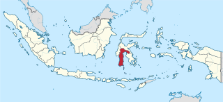
South Sulawesi is a province in the southern peninsula of Sulawesi. The Selayar Islands archipelago to the south of Sulawesi is also part of the province. The capital is Makassar. The province is bordered by Central Sulawesi and West Sulawesi to the north, the Gulf of Bone and Southeast Sulawesi to the east, Makassar Strait to the west, and Flores Sea to the south.
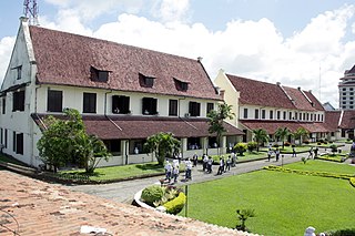
Makassar is the capital of the Indonesian province of South Sulawesi. It is the largest city in the region of Eastern Indonesia and the country's fifth-largest urban center after Jakarta, Surabaya, Medan, and Bandung. The city is located on the southwest coast of the island of Sulawesi, facing the Makassar Strait.

Poso is the administrative capital of Poso Regency, Indonesia. It is the main port and transportation hub for the central-southern coast of Central Sulawesi. Its urban area consists of three districts, Poso Kota, North Poso Kota, and South Poso Kota. Poso lies in the middle of the province on the shore of the Gulf of Tomini, right in the central part of Sulawesi island. With a total population of 47,477 in 2020, it is one of the biggest and the oldest towns in the province.

North Sulawesi is a province of Indonesia. It is located on the Minahasa Peninsula of Sulawesi, south of the Philippines and southeast of Sabah, Malaysia. It borders the Philippine province of Davao Occidental and Soccsksargen regions of the Philippines to the north, the Maluku Sea to the east, Gorontalo and Celebes Sea to the west and the Gulf of Tomini to the southwest. With Miangas, it is the northernmost province of Indonesia. The province's area is 13,892.47 square kilometres (5,363.91 sq mi), and its population was 2,270,596 according to the 2010 census; this rose to 2,621,923 at the 2020 Census, while the official estimate as at mid 2021 was 2,638,631.
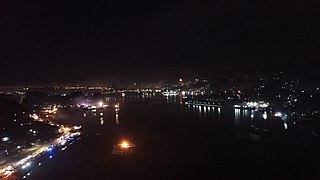
Kendari is the capital city of the Indonesian province of Southeast Sulawesi. With a population of 345,107 according to the 2020 census, it is the most populous city in the province, and the fourth most on Sulawesi. The city covers an area of 271.76 square kilometers (104.93 sq mi), or about 0.7 percent of Southeast Sulawesi's land area. Located on Kendari Bay, it continues to be an important trade center, with the province's main port and airport. It is the economic and educational center of the province, home to various universities and colleges. Kendari has the highest Human Development Index (HDI) in Sulawesi.

Gorontalo is a city and the capital of the Gorontalo Province, Indonesia. It is on the island of Sulawesi. The city has an area of 79.59 km2 and had a population of 179,991 at the 2010 census and 198,539 at the 2020 census; the official estimate as at mid 2021 was 199,788.
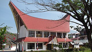
Rantepao is a town and capital of North Toraja Regency, which is known for the cultural center of Toraja ethnic group. National and regional tourism offices have developed the city as the starting point for visiting Tana Toraja, since the area was opened for tourism in the 1970s.

Majene is the administrative capital of Majene Regency and it is located in the Indonesian province of West Sulawesi.

Gowa is a regency in the province of South Sulawesi, Indonesia. It has an area of 1,883.33 km2 and a population of 652,329 at the 2010 census, increasing to 765,836 at the 2020 census; the official estimate as at mid 2021 was 773,315. The majority of the regency lies within the official metropolitan area of the city of Makassar, including the regency's administrative capital at Sungguminasa. The hill resort of Malino is within the eastern (non-metropolitan) part of the regency.

Mamuju Regency is a regency of West Sulawesi province, Indonesia. The regency capital is at Karema, while Mamuju town is the capital of West Sulawesi. The population of the regency was 336,879 at the 2010 Census, but it was substantially reduced by the creation of the new Central Mamuju Regency which was cut out of it in 2012. The reduced Mamuju Regency covers an area of 4,954.57 km2 and had a population of 278,764 at the 2020 Census. The official estimate as at mid 2021 was 281,854.
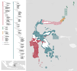
On the Indonesian island of Sulawesi, 114 native languages are spoken, all of which belong to the Malayo-Polynesian subgroup of the Austronesian language family. With a total number of 17,200,000 inhabitants, Sulawesi displays a high linguistic diversity when compared with the most densely populated Indonesian island Java, which hosts 4–8 languages spoken by 145,100,000 inhabitants.
Paguyaman River is a river in Gorontalo (province), Sulawesi island, Indonesia, about 1900 km northeast of capital Jakarta.

Pasangkayu Regency is one of the six regencies which comprise West Sulawesi Province, Indonesia, on the island of Sulawesi. It covers an area of 3,043.75 km2 and had a population of 134,303 at the 2010 Census and 188,861 at the 2020 Census. The official estimate as at mid 2021 was 193,098. The town of Pasangkayu is the capital of the regency, and its only urban community (kelurahan).

Luwu Regency is a regency of South Sulawesi Province, Indonesia. The administrative capital now lies at Belopa, since the former capital (Palopo) became an independent municipality (city) in 2006, at which date the then existing Luwu Regency was split into four entities - Palopo city, North Luwu Regency, East Luwu Regency, and the residual Luwu Regency. The regency now covers 2,909.08 km2 and had a population of 287,472 at the 2010 census and 365,608 at the 2020 census. The official estimate as at mid 2021 was 367,454.
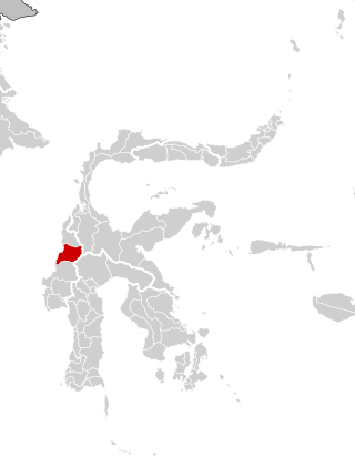
Central Mamuju Regency is a regency in the province of West Sulawesi, Indonesia. The regency was established on 14 December 2012, comprising five regencies which had formerly been part of Mamuju Regency. It covers an area of 3,100.87 km2 and had a population of 105,495 at the 2010 Census and 135,280 at the 2020 Census.

Gorontalo is a province of Indonesia on the island of Sulawesi. Located on the Minahasa Peninsula, Gorontalo was formerly part of the province of North Sulawesi until its inauguration as a separate province on 5 December 2000. In Indonesian history, the only Indonesian President from the Gorontaloan people is the third President of the Republic of Indonesia, Prof. DR. Ing. Bacharuddin Jusuf Habibie. His father, Alwi Abdul Jalil Habibie, comes from the "Habibie" clan.
An earthquake struck Majene Regency in the province of West Sulawesi, on the Indonesian island of Sulawesi on 15 January 2021, at 02:28 WITA, with a moment magnitude of 6.2. This earthquake was felt as far away as Makassar, the capital of South Sulawesi, and Palu in Central Sulawesi. Strong shaking was reported in Majene and the provincial capital Mamuju for at least 5–7 seconds. It was preceded by a foreshock measuring 5.7 magnitude a few hours earlier.
The COVID-19 pandemic in West Sulawesi is a part of wider outbreak in Indonesia. The virus was confirmed to reach the province on 29 March 2020. As of 8 December 2021, there are confirmed 12,357 cases detected with 12,007 recoveries and 346 deaths.


