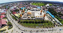
Tanjung Selor

Last updated
Tanjung Selor
Masjid Agung Tanjung Selor.jpg
A view of Tanjung Selor
Indonesia Kalimantan location map.svg
Red pog.svg
Tanjung Selor
Location in Kalimantan and Indonesia
Indonesia location map.svg
Red pog.svg
Tanjung Selor
Tanjung Selor (Indonesia)
Coordinates: 2°51′0″N117°23′0″E / 2.85000°N 117.38333°E / 2.85000; 117.38333
Country Flag of Indonesia.svg  Indonesia
Province Flag of North Kalimantan.svg  North Kalimantan
Regency Bulungan
Founded12 October 1790
Area
  Total677.77 km2 (261.69 sq mi)
Elevation
24 m (79 ft)
Population
 (2020 Census)
  Total56.569
  Density0.083/km2 (0.22/sq mi)
  [1]
Time zone UTC+8 (Indonesia Central Time)
Area code (+62) 553

Tanjung Selor is the capital of both the North Kalimantan province in Indonesia, and of the Bulungan Regency. It is among provincial capitals in Indonesia that as of 2021 does not yet have city status, together with Mamuju in West Sulawesi, Sofifi in North Maluku, Nabire in Central Papua, Wamena in Highland Papua, Merauke in South Papua, and Manokwari in West Papua. The district has an area of 677.77 km2 and had a population of 39,439 at the 2010 Census [2] and 56,569 at the 2020 Census. [3]

Contents

History

Tanjung Selor was a small market town under the Sultanate of Bulungan, which later became the subject of the Dutch East Indies. After the Indonesian National Revolution, it became part of the Swapraja (Autonomous Royal Region) of Bulungan following Decree No. 186/ORB/ 92/14/1950 from the then-Kalimantan province governor. This later changed again into the Special Region of Bulungan under Law No. 22 of 1955. In 1959, the sultanate was abolished and became a second-level administrative region, now called a regency. [4] [5] [6]

Tanjung Selor was split from Tanjung Palas District, based on Bulungan Regency Law No. 13 of 2002, together with other seven new districts after the decentralization. Before the creation of the new North Kalimantan province split from East Kalimantan, it was determined to locate the provincial capital on mainland Kalimantan rather than in the then-largest provincial city of Tarakan, which is an island. As such, Tanjung Selor is among few Indonesian provincial capitals to be created from scratch, along with Sofifi and Palangka Raya. However, for financial reasons a moratorium under President Joko Widodo on creating second-level administrations so far has prevented granting Tanjung Selor city status. As of 2022, North Kalimantan remains among few of Indonesian provinces with its capital not having city status. [7] [8]

Geography

The district is mostly a flat, low-lying region with hills whose height varies from 0 to 500 meters above sea level. Borders of The district borders Central Tanjung Palas District in the north, East Tanjung Palas District in the east and the south, and Kayan river in the west. Soil in the district is acidic, with a pH range between 4 and 6. Another river, the Selor, also runs through the district. [9] [10]

Climate

Tanjung Selor has a tropical rainforest climate (Köppen Af) with heavy rainfall year-round.

Climate data for Tanjung Selor
MonthJanFebMarAprMayJunJulAugSepOctNovDecYear
Average high °C (°F)30.0
(86.0)
30.0
(86.0)
30.2
(86.4)
30.5
(86.9)
30.8
(87.4)
30.5
(86.9)
30.7
(87.3)
30.8
(87.4)
30.9
(87.6)
31.0
(87.8)
30.8
(87.4)
30.3
(86.5)
30.5
(87.0)
Daily mean °C (°F)26.5
(79.7)
26.5
(79.7)
26.7
(80.1)
27.0
(80.6)
27.2
(81.0)
26.8
(80.2)
26.9
(80.4)
26.9
(80.4)
27.0
(80.6)
27.0
(80.6)
27.1
(80.8)
26.8
(80.2)
26.9
(80.4)
Average low °C (°F)23.0
(73.4)
23.0
(73.4)
23.3
(73.9)
23.5
(74.3)
23.6
(74.5)
23.2
(73.8)
23.1
(73.6)
23.1
(73.6)
23.1
(73.6)
23.1
(73.6)
23.4
(74.1)
23.3
(73.9)
23.2
(73.8)
Average rainfall mm (inches)235
(9.3)
235
(9.3)
212
(8.3)
186
(7.3)
222
(8.7)
189
(7.4)
207
(8.1)
213
(8.4)
229
(9.0)
229
(9.0)
281
(11.1)
278
(10.9)
2,716
(106.8)
Source: [11]

Economy

Agricultural land use includes chilis, tomatoes, ginger, galangal, and turmeric. Chili production was 337 tons in 2019, with 295 tons of tomatoes, 57 tons of ginger, 52 tons of galangal, and four tons of turmeric. The district also includes plantation sectors which produce mangoes, citrus, durian, and bananas. There are 68 registered restaurants in the district as of 2019 and 12 convenience stores. There also are 11 hotels as of 2019. Twelve banks operate in the district, of which nine are branches of state-owned banks, two are private banks, and one, the People's Credit Bank, is a municipally-owned BPR. There also are 45 registered cooperatives. [12]

Governance

Office building of North Kalimantan governor. Tanjung Selor is one of only four provincial capitals that does not have city status. Kantor Gubernur Kalimantan Utara.JPG
Office building of North Kalimantan governor. Tanjung Selor is one of only four provincial capitals that does not have city status.

As a district, it is a third-level administrative region under a regency. A district head(camat) is appointed directly by the regent with recommendation from the regency secretary. Tanjung Selor itself has no parliament. [13] [14] The district is divided into nine urban villages (kelurahan).

At the regency level, the district, together with East Tanjung Palas, is part of the Bulungan first electoral district, which sends 11 representatives to the regency-level parliament. The latest election was in 2019, and the next is expected in 2024. [15]

Infrastructure

Dr. H. Soemarno Sosroatmodjo Regional Hospital, the only operational hospital in the district as of 2019 RSUD Dr. H. Soemarno Sosroatmodjo Tanjung Selor.JPG
Dr. H. Soemarno Sosroatmodjo Regional Hospital, the only operational hospital in the district as of 2019

The district is served by the Tanjung Harapan Airport. All roads in the district are asphalt-paved and in good condition as of 2020, according to Statistics Indonesia. As of 2019, the district has 35 elementary schools, 19 junior high schools, 10 senior high schools, three vocational high schools, and three higher education institutions. There is also one hospital, 11 puskesmas government health clinics, three additional clinics, seven healthcare centers, and 17 pharmacies. Most of the district is reached by 4G wireless signal and basic telecommunication services. [12] [16] [17] The district's hospital, Dr. H. Soemarno Sosroatmojo Regional Hospital, is a public hospital owned by the regency government; built in 1984, it is classified as a C-class hospital by the Ministry of Health. [18] [19]

Related Research Articles

<span class="mw-page-title-main">Provinces of Indonesia</span> The first-level subdivision of Indonesia

Provinces of Indonesia are the 38 administrative divisions of Indonesia and the highest tier of the local government. Provinces are further divided into regencies and cities, which are in turn subdivided into districts (kecamatan).

<span class="mw-page-title-main">East Kalimantan</span> Province of Indonesia

East Kalimantan is a province of Indonesia. Its territory comprises the eastern portion of Borneo. It had a population of about 3.03 million at the 2010 census, 3.42 million at the 2015 census, and 3.766 million at the 2020 census; the official estimate as at mid 2022 was 3,859,783. Its capital is the city of Samarinda.

<span class="mw-page-title-main">Kapuas Hulu Regency</span> Regency in West Kalimantan, Indonesia

Kapuas Hulu Regency is a regency in West Kalimantan province of Indonesia. Located around Kapuas River, it has a total area of 29,842.03 square kilometres or around 20.26% of West Kalimantan province's area. The regency seat is located in town of Putussibau, where most of its economic and government activities take place. Due to its relatively large area, it is sparsely populated compared to neighbouring regencies around it. The regency had a population of 222,160 at the 2010 Census and 252,609 according to the 2020 Census; the official estimate as at mid 2022 was 254,995.

<span class="mw-page-title-main">Bulungan Regency</span> Regency in North Kalimantan, Indonesia

Bulungan Regency is a regency of North Kalimantan Province in Indonesia. It covers an area of 13,181.92 km2 and had a population of 112,663 at the 2010 Census and 151,844 at the 2020 Census; the official estimate as at mid 2022 was 157,593. The administrative centre is at Tanjung Selor.

<span class="mw-page-title-main">Kotabaru Regency</span> Regency of Indonesia

Kotabaru Regency is one of the eleven regencies in the Indonesian province of South Kalimantan. It consists of two parts; the smaller but more populated part comprises Laut Island, the largest island off the coast of Kalimantan, together with the smaller Sebuku Island off Laut Island's east coast and even smaller islands nearby; the larger but less populated part consists of districts on the mainland of Kalimantan. The regency as a whole has an area of 9,480.17 km2, and had a population of 290,142 at the 2010 Census and 325,622 at the 2020 Census. The official estimate as at mid 2022 was 334,158, of whom 178,660 were in the insular part and 155,498 in the mainland part of the regency. The regency seat is located at the large town of Kotabaru at the northern tip of Laut Island.

<span class="mw-page-title-main">Kandangan</span> Town in South Kalimantan, Indonesia

Kandangan is a district and the regency seat of South Hulu Sungai Regency in South Kalimantan province. The district covers an area of 106.71 square kilometres. According to the mid 2022 official estimates, the population of the district was 49,604 people spread across 4 urban kelurahan and 14 rural villages (desa).

<span class="mw-page-title-main">Tarakan</span> City in Kalimantan, Indonesia

Tarakan is an island and co-extensively the sole city within the newly established Indonesian province of North Kalimantan. The island city is located in northern Borneo, midway along the coast of the province. The city boundaries are co-extensive with the island. Once a major oil-producing region during the colonial period, Tarakan had great strategic importance during the Pacific War and was among the first Japanese targets early in the conflict. It is the sole city within the newly established Indonesian province of North Kalimantan. According to Statistics Indonesia, the city had a population of 193,370 at the 2010 Census and 242,786 inhabitants at the 2020 Census; the official estimate as at mid 2022 was 248,972 (comprising 128,895 males and 120,077 females.

<span class="mw-page-title-main">Penajam North Paser Regency</span> Regency in East Kalimantan, Indonesia

Penajam North Paser Regency is a regency in the Indonesian province of East Kalimantan. Its administrative centre is the town of Penajam. The area which now forms Penajam North Paser was part of Paser Regency until its creation as a separate regency on 10 April 2002. It covers an area of 3,333.06 km2 and it had 142,922 inhabitants at the 2010 census and 178,681 at the 2020 census; the official estimate as at mid 2022 was 183,043. Penajam North Paser Regency has the smallest area among the seven regencies in East Kalimantan province.

<span class="mw-page-title-main">Kayan River</span> River in Indonesia

The Kayan River is a river of Borneo island, flowing in the North Kalimantan province of Indonesia, about 1600 km northeast of the capital Jakarta. Tributaries include the Bahau River.

<span class="mw-page-title-main">North Kalimantan</span> Province of Indonesia

North Kalimantan is a province of Indonesia. It is located on the northernmost of Kalimantan, the Indonesian part of the island of Borneo. North Kalimantan borders the Malaysian states of Sabah to the north and Sarawak to the west, and by the Indonesian province of East Kalimantan to the south. Tanjung Selor serves as the capital of the province, while Tarakan is the largest city and the financial centre.

<span class="mw-page-title-main">South Barito Regency</span> Regency in Central Kalimantan, Indonesia

South Barito Regency is a regency in Central Kalimantan province of Indonesia. On 10 April 2002 the eastern districts were split off to create a new East Barito Regency, while the residual South Barito District has an area of 7,020 km2. The regency seat is located in town of Buntok, located in South Dusun district. The population of South Barito Regency was 124,128 at the 2010 Census and 131,140 at the 2020 Census; the official estimate as at mid 2022 was 131,997.

<span class="mw-page-title-main">Sultanate of Bulungan</span>

The Sultanate of Bulungan was a princely state of Indonesia located in the then existing Bulungan Regency in the east of the island of Borneo. Its territory spanned the eastern shores of North Kalimantan and Tawau, Malaysia.

<span class="mw-page-title-main">Gunung Mas Regency</span> Regency in Indonesia

Gunung Mas Regency is one of the thirteen regencies of Central Kalimantan Province, Indonesia. The regency seat is located at the town of Kuala Kurun in Kurun District. The population of Gunung Mas Regency was 96,900 at the 2010 census ; and 135,373 at the 2020 census; the official estimate as at mid 2022 was 142,309.

<span class="mw-page-title-main">Malinau Regency</span> Regency in North Kalimantan, Indonesia

Malinau Regency is a regency of North Kalimantan Province in Indonesia. It was created on 4 October 1999 from the western districts of Bulungan Regency. The administrative centre is the town of Malinau. The regency is home to the Kayan Mentarang National Park. It covers an area of 38,973.56 km2, and had a population of 62,423 at the 2010 Census and 82,510 at the 2020 Census; the official estimate as at mid 2022 was 85,316. It is the regency with the largest area in the province, as well as the least densely populated. Other than that, Malinau is the only regency in North Kalimantan that is predominantly Protestant and the second most-developed region in North Kalimantan after Tarakan in terms of Human Development Index.

<span class="mw-page-title-main">Tana Tidung Regency</span> Regency of Indonesia

Tana Tidung Regency is a regency within the Indonesian province of North Kalimantan. It is Indonesia's least populous regency, with 25,584 inhabitants recorded in the 2020 census; the official estimate as at mid 2022 was 27,571. Its regency seat is the town of Tideng Pale, in Sesayap District, where 11,280 of the regency's population lived in mid 2022.

<span class="mw-page-title-main">Sekadau Regency</span> Regency in West Kalimantan, Indonesia

Sekadau Regency is a regency of West Kalimantan province of Indonesia. It was created on 18 December 2003 from the eastern part of Sanggau Regency. It covers an area of 6,275.39 km2, and had a population of 181,634 at the 2010 Census and 211,559 at the 2020 Census; the official estimate as at mid 2022 was 214,429. The regency seat lies at the town of Sekadau in Sekadau Hilir District.

<span class="mw-page-title-main">Sangihe Islands Regency</span> Regency of Indonesia

The Sangihe Islands Regency is a regency of North Sulawesi Province, Indonesia. It comprises a group of islands situated to the North of Sulawesi. It covers a land area of 736.98 km2, and had a population of 126,100 at the 2010 census and 139,262 at the 2020 census; the official estimate as at mid 2022 was 140,165. The principal island is also named Sangihe, on which lies the main town of Tahuna. Minor island groups within the Regency include the Marore group considerably to the north of Sangihe Island, the Tatoareng group to the south, and the Nusa Tabukan group off the northeast coast of Sangihe Island. It borders the Philippines in the north, making it one of Indonesia's border regions.

The Bulungan language is an Austronesian language spoken in Bulungan Regency, North Kalimantan. The language was the court language of the Bulungan Sultanate. The classification of this language is not clear. Glottolog places it in the Sabahan group.

References

  1. Badan Pusat Statistik, Jakarta, 2021.
  2. Biro Pusat Statistik, Jakarta, 2011.
  3. Badan Pusat Statistik, Jakarta, 2021.
  4. prokal.co. "Beri Pemahaman Sejarah Tanjung Selor | Radar Tarakan". kaltara.prokal.co (in Indonesian). Retrieved 2021-04-25.
  5. "Sejarah Bulungan".
  6. "JPNN". www.jpnn.com (in Indonesian). 2016-05-17. Retrieved 2021-04-25.
  7. Media, Kompas Cyber (2019-03-31). "Tanjung Selor, Model Pengembangan Ibu Kota Baru". KOMPAS.com (in Indonesian). Retrieved 2021-04-25.
  8. "Sejarah Kecamatan". Kecamatan Tanjung Selor. 2019-05-17. Retrieved 2021-04-25.
  9. "Geografis". Kecamatan Tanjung Selor. 2019-05-17. Retrieved 2021-04-25.
  10. "Kecamatan Tanjung Selor".
  11. "Tanjung Selor climate: Average Temperature, weather by month, Tanjung Selor weather averages - Climate-Data.org". en.climate-data.org. Retrieved 2021-12-26.
  12. 1 2 "Kecamatan Tanjung Selor Dalam Angka 2020".
  13. Government Law No.19 1998
  14. "PP No. 17 Tahun 2018 tentang Kecamatan [JDIH BPK RI]". peraturan.bpk.go.id. Retrieved 2021-04-25.
  15. "Keputusan KPU Kaltara" (PDF).
  16. prokal.co. "4G Hanya di Tiga Titik | Harian Rakyat Kaltara". rakyatkaltara.prokal.co (in Indonesian). Retrieved 2021-04-25.
  17. "Wilayah Muara Bulungan Kini Terbebas dari Blank Spot". Niaga.Asia (in Indonesian). 2020-02-03. Retrieved 2021-04-25.
  18. "Informasi SDM Kesehatan Nasional". bppsdmk.kemkes.go.id. Retrieved 2021-04-25.
  19. "RSUD dr. H. SOEMARNO SOSROATMODJO TANJUNG SELOR". rsutanjungselor.com. Retrieved 2021-04-25.