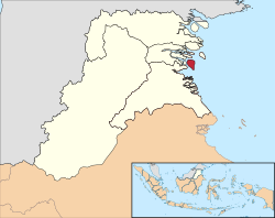
Tarakan is an island and co-extensively the sole city within the Indonesianprovince of North Kalimantan. The island city is the largest urban area in North Kalimantan population-wise and is located in northern Borneo, midway along the coast of the province. The city boundaries are co-extensive with the island (including a couple of small islands off the coast of the Tarakan Barat District). Once a major oil-producing region during the colonial period, Tarakan had great strategic importance during the Pacific War and was among the first Japanese targets early in the conflict. It is the sole city within the Indonesian province of North Kalimantan (established in 2012). According to Statistics Indonesia, the city had a population of 193,370 at the 2010 Census[3] and 242,786 inhabitants at the 2020 Census;[4] the official estimate as at mid 2024 was 255,310 (comprising 132,175 males and 123,135 females).[1]
The city is located on Tarakan island (off the east coast of Kalimantan), which composed of 8,635 hectares (21,340 acres) of land.[5] 27.5% of the city is composed of podzol soil and 57.63% latosol soil.[5] The city is located between 0–110 metres (0–361ft) above sea level.[5]
History
Etymology
According to legends, native Tidungs established their kingdom in Tarakan around 1076 CE. After moving their capital several times over the centuries, in 1571 CE they settled their kingdom on the eastern coast of Tarakan, apparently already under the influence of Islam.[6] The name Tarakan comes from the Tidung language:[which?]tarak (meeting place) and ngakan (to eat); thus Tarakan was originally a meeting place for sailors and traders to eat, rest and trade their catch in the Tidung area.[7]
Petroleum
Oil storage tanks and a pier at Tarakan photographed between 1905 and 1914A pier and oil barrels in Tarakan during the Dutch colonial period, ca. 1925
Dutch explorers noted oil seepages in 1863. In 1905, an oil concession was granted to Koninklijke Nederlandsche Petroleum Maatschappij' a predecessor to Royal Dutch Shell. One year later oil production began with a yield of over 57,928 barrels of oil per year. Production continued to increase and in the 1920s Tarakan yielded over five million barrels a year, a third of the total oil production in the whole of the Dutch East Indies.[8]
Japan had captured the Miri oil-field in Sarawak in December 1941, and captured oil-fields and refineries at Balikpapan in Dutch Borneo in January 1942, Sumatra in February, and Java in March. Oil technicians accompanied the invading Japanese troops to maintain production at captured facilities. A team of one thousand additional petroleum engineers and technicians sailed from Japan aboard the Taiyo Maru, but nearly 800 drowned when USS Grenadier sunk the Taiyo Maru southwest of Kyushu on 8May 1942.[16] Despite this loss, Tarakan crude oil (mixed with lesser quantities of Manchurianoil-shale distillates) became the primary feedstock for Japanese diesel fuel in 1942, while reserve supplies of California crude oil remained the primary feedstock for Japanese gasoline and residual fuels until 1943.[12]
Allied landing vessels during the Battle of Tarakan (1945)
Tarakan became a Japanese strategic air-base from which further attacks could be launched following the Dutch surrender. Tarakan's inhabitants suffered under Japan's occupation. The large number of Japanese troops stationed on the island led to food-shortages and many civilians suffered from malnutrition. During the occupation, the Japanese transported some 600 labourers to Tarakan from Java. The Japanese also forced an estimated 300 Javanese women to work as "comfort women".
Tarakan oil-field production reached 350,000 barrels per month by early 1944, but Japan no longer had enough oil tankers to transport this volume to Japanese refineries. Without adequate supplies of refined residual fuel-oil for the forthcoming Battle of the Philippine Sea, Japanese aircraft-carriers refueled with unrefined Tarakan crude-oil in June 1944. The undesalted crude-oil damaged boiler tubes, and the unremoved naphtha fraction volatilized to form explosive atmospheres, contributing to the loss of the aircraft carriers Taihō, Shōkaku, and Hiyō.[11]
The last Japanese tanker left Tarakan in July 1944; Allied bombing-raids damaged the oil-field facilities later that year; and the veteran Australian 26th Brigade Group ended the Japanese occupation of the area with the second Battle of Tarakan (1May to 21June 1945).[17]
Independence Era
Following the Indonesian revolution in the late 1940s, Tarakan became part of the new republic. It was administered as a district following a Presidential Decree Number 22, 1963.[5] In 1981, Tarakan was granted a city charter, at that time one of four cities in East Kalimantan, along with Samarinda, Balikpapan and Bontang in accordance with Government Law Number 47, 1981.
Tarakan had a population of 193,370 at the 2010 Census,[3] but the 2020 Census this had grown to 242,786,[4] and the official estimate as at mid 2024 was 255,310. Indigenous residents include the Tidung, a subgroup of the Dayak people. The city also has a multi-ethnic population from other parts of Indonesia, such as Bugis, Javanese, and Chinese Indonesians. Apart from that, there are also Tausug whose origins are from the Sulu Islands, as well as Malays, and Mandarese. 85% of the city's population is Muslim, around 10% are Christian, 1.3% Hindu, 0.04% Buddhist, and 0.03% Confucianist.[21]
*Notes: "Dayaks" consists of various sub-ethnic groups; "Others" is a classification of various other ethnic groups that are not recorded (IPUMS and BPS Kota Tarakan, 2010).[22]
Population growth averaged 2.23% per year in the decade 2010–2020. The city population has increased rapidly which is thought to be caused by high urbanization rate with people moving in from neighbouring regions. The sex ratio as of 2020 was 100:109—100 females for every 109 males. The city is dominated by a young and reproductive age population above the age of 15, which accounts around 64.53% of city's population. Life expectancy in the city as of 2020 was 74 years, which is considerably higher than both the provincial and national average; it has been increasing consistently.[23]
Infrastructure
Health
Tarakan Regional Hospital
The island's main healthcare infrastructure consists of four hospitals, eight puskesmas (community health centers), and 103 healthcare centers. In addition, there are seven mobile puskesmas,[5][23] the biggest being Tarakan Regional Hospital, owned by the city government, located in Central Tarakan district.[24] It is also the only international-class hospital in the province and is the province's referral hospital.[23]
There is also a navy hospital, owned by the Indonesian Navy, located in West Tarakan district.[25]
Education
There are 27 kindergartens, 65 elementary schools, 21 junior high schools and 12 senior high schools. There are also five institutions of higher education in the city, the most notable being Borneo Tarakan University,[23] which is also the only public university in the city and the province.[26]
There are also seven vocational high schools.[5][23] School participation rate is around 99% as of 2020.[23]
Borneo Tarakan University rector building
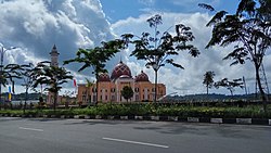
Places of worship
Al-Ma'arif Grand Mosque, Tarakan
There are 235 mosques, 93 churches, four Chinese Buddhist temples, and one Hindu temple.[23] One of the biggest mosques, Al-Ma'arif Grand Mosque, was constructed in 1961 and is located in the Central Tarakan district.[27] The only Hindu temple in the city, Pura Giri Jagat Nata, was inaugurated on 1994, and is used mostly by Balinese migrants.[28] The Tarakan Islamic Center functions not only as a mosque but is also used for Islamic learning and various Islamic events. A popular local tourist spot, it was inaugurated in 2012.[29]
Communication
The city has access to 4G and other telecommunication services.[30] As with most Indonesian cities, the only fiber optic service provider in the city is IndiHome, which is state-owned under Telkomsel.[31][32] The city has fiber optic cables connected to Balikpapan and Samarinda, which also serve other regencies of North Kalimantan province.[33]
Inauguration of Juwata International Airport new terminal by President Joko Widodo
Tarakan has an airport, Juwata International Airport, located 3.5 kilometres (2.2mi) from the city center. The airport handles domestic flight routes to Balikpapan, Jakarta, Surabaya, Denpasar and Makassar, as well as an international route to Tawau, Malaysia. On 2016, the airport terminal was expanded to provide for more than 2,000 passengers per day.[35] There are 281.911 kilometres (175.171mi) of road in the city of which 201.571 kilometres (125.250mi) have been paved with asphalt.[23] The city has a bus rapid transit system which connects the entire city.[36][37] In addition, there are angkots (shared taxis) and online motorcycle taxi services provided by firms like Gojek and Grab, and conventional taxis.[38][39]
There is a plan to build a bridge connecting the island to mainland Kalimantan, which is currently delayed because of the government refocusing fund allocations from development and infrastructure to COVID-19 pandemic mitigation.[40]
Economy
An oil field in TarakanTarakan city center in 2009
The city was once a leading oil producer in the Dutch East Indies; to-day however, oil only comprises six percent of the total Tarakan economy. Fisheries and processed products now dominate the economy.[41][23] The city is still the biggest contributor to the North Kalimantan economy, contributing 37.05 percent.[42] The economic growth in 2015 was 7.52 percent, which is above the national average.[43] The unemployment rate in 2019 was 4.78 percent.[44] There are 14 companies based in Tarakan as of 2019.[45] As a result, in 2021 it is the 17th richest city in Indonesia.[46] The poverty rate as of 2020 was around 6 percent.[23]
The agriculture sector is small, with only 33 hectares (82 acres) being cultivated as paddy fields. It has been declining massively since 2018, with drops as high as 45.81 percent of crop yields. Other agriculture products such as cassava and sweet potatoes are also declining, with each only using around 174 hectares (430 acres) and 10 hectares (25 acres) respectively. Tourism has been a growing sector, with around 227,638 tourists visiting the city in 2019. There are 33 registered banks in the city as of 2020, consisting of 23 public banks and 10 private banking institutions.[23]
Governance
Administrative districts
The city is divided into four districts (kecamatan), tabulated below with their land areas and their populations at the 2010 census[3] and 2020 Census,[4] together with the official estimates as at mid 2024.[1] The table also includes the number of administrative villages (all rated as urban kelurahan) in each district, and its postal codes.
Kode Wilayah
Name of District (kecamatan)
Area in km2
Pop'n Census 2010
Pop'n Census 2020
Pop'n Estimate mid 2024
No. of villages
Post codes
65.71.03
Tarakan Timur (East Tarakan)
58.01
42,973
58,500
62,380
7
77115 & 77123-77126
65.71.02
Tarakan Tengah (Central Tarakan)
55.54
60,608
69,740
71,180
5
77113-77114
65.71.01
Tarakan Barat (West Tarakan)
27.89
67,749
81,800
85,230
5
77111-77112
65.71.04
Tarakan Utara (North Tarakan)
109.36
22,040
32,740
36,520
3
77116
Totals
250.80
193,370
242,786
255,310
20
Local Government
As with all Indonesian cities, it is a second-level administrative division run by a mayor and vice mayor together with the city parliament, and it has a status equivalent to a regency.[47] Executive power lies in the mayor and vice mayor, while legislative duties are carried out by local parliaments. The mayor, vice mayor, and parliament members are democratically elected by the people of the city in an election.[48] The heads of districts are appointed directly by the city mayor with recommendations by the city secretary.[49][50]
Tarakan city is part of 1st electoral district for provincial parliament (North Kalimantan People's Representative Council), and have 12 out of 35 representatives there.[51] In city level, it has its own parliament consist of 30 representatives divided into four electoral districts.[52] The last election for parliament was on 17 April 2019 and the next one will be in the year 2024.[52]
↑Dull, Paul (12 December 2012) [1978]. "Isolation of Java". A Battle History of the Imperial Japanese Navy: 1941-1945. Annapolis, Maryland: Naval Institute Press. pp.61–62. ISBN9781612512907. Retrieved 22 April 2024. By the afternoon of 10 January the [Japanese] convoy [...] was just off Tarakan Island. The Dutch garrison commander, on his own initiative, immediately set fire to Tarakan's oil fields and sabotaged its airfield. At 2400, the landing troops began a double envelopment, and on the morning of 12 January the small Dutch garrison surrendered, facing overwhelming odds, without any hope of reinforcement.
↑Dull, Paul S. The Imperial Japanese Navy (1941-1945) (1978) Naval Institute Press p.66
This page is based on this Wikipedia article Text is available under the CC BY-SA 4.0 license; additional terms may apply. Images, videos and audio are available under their respective licenses.