
An earthquake occurred in the province of Sichuan, China at 14:28:01 China Standard Time on May 12, 2008. Measuring at 8.0 , the earthquake's epicenter was located 80 kilometres (50 mi) west-northwest of Chengdu, the provincial capital, with a focal depth of 19 km (12 mi). The earthquake ruptured the fault for over 240 km (150 mi), with surface displacements of several meters. The earthquake was also felt as far away as both Beijing and Shanghai—1,500 and 1,700 km away, respectively—where office buildings swayed with the tremor, as well as Bangkok, Thailand and Hanoi, Vietnam. Strong aftershocks, some exceeding 6 , continued to hit the area up to several months after the main shock, causing further casualties and damage. The earthquake also caused the largest number of geohazards ever recorded, including about 200,000 landslides and more than 800 quake lakes distributed over an area of 110,000 km2 (42,000 sq mi).

The 2008 Panzhihua earthquake struck southern Sichuan province, China on August 30 at with a surface wave magnitude of 6.1, or 6.0 . It is also cited as the Renhe-Huili earthquake, especially in SCEA reports and early CEA reports. It was not an aftershock of the Sichuan earthquake that occurred several months prior. With more than 400 aftershocks, it caused over 40 deaths, the collapse of 10,000 homes and damage to other infrastructure in the provinces of Sichuan and Yunnan. The maximum liedu was VIII.
The 2008 Yingjiang earthquakes were a series of major earthquakes ranging from surface wave magnitude (Ms) 4.1 to 5.9 that struck Yingjiang County, Yunnan province, China between August 19 and September 3. It caused 5 deaths, 130 injuries, and RMB 2.7 billion in direct economic damage. USGS put the magnitude of the strongest one to Mw 6.0.
The 2010 Yushu earthquake struck on April 14 and registered a magnitude of 6.9 Mw or 7.1 Ms. It originated in Yushu, Qinghai, China, at 7:49 am local time. According to the Xinhua News Agency, 2,698 people were confirmed dead, 270 missing and 12,135 injured, 1,434 of them severely. The epicenter was located in Rima village (日玛村/日麻村), Upper Laxiu township (上拉秀乡) of Yushu County, in remote and rugged terrain, near the border of Tibet Autonomous Region, about 30 km from Gyêgu town or Jyekundo, the seat of Yushu County, and about 240 km from Qamdo. The epicenter was in a sparsely populated area on the Tibetan plateau that is regularly hit by earthquakes.
Thrangu Monastery is located about 7 km south of Jyekundo in the Yushu Tibetan Autonomous Prefecture of Qinghai province, China, or the traditional Tibetan cultural region of Kham.
A potent magnitude 6.6 Mw intraplate aftershock occurred at 17:16 JST (08:16 UTC) on 11 April, in the Hamadōri region of Fukushima, Japan. With a shallow focus of 13 km (8.1 mi), the earthquake was centred inland about 36 km (22 mi) west of Iwaki, causing widespread strong to locally severe shaking. It was one of many aftershocks to follow the 11 March Tōhoku earthquake, and the strongest to have its epicentre located inland.

The Lushan earthquake or Ya'an earthquake occurred at 08:02 Beijing Time on April 20, 2013. The epicenter was located in Lushan County, Ya'an, Sichuan, about 116 km (72 mi) from Chengdu along the Longmenshan Fault in the same province heavily impacted by the 2008 Sichuan earthquake. The magnitude of the earthquake was placed at Ms 7.0 by China Earthquake Data Center, Ms 7.0 by Russian Academy of Sciences, Mw 7.0 by Geoscience Australia, Mw 6.6 by the United States Geological Survey (USGS), Mw 6.6 by the European Alert System (EMSC) and Mj 6.9 by the Japan Meteorological Agency (JMA). 1,815 aftershocks have been recorded as of 00:00 (UTC+8h) April 22.

The 2014 Ludian earthquake struck Ludian County, Yunnan, China, with a moment magnitude of 6.1 on 3 August. The earthquake killed at least 617 people, injuring at least 2,400 others. As of 5 August 2014, 112 people remain missing. Over 12,000 houses collapsed and 30,000 were damaged. According to the United States Geological Survey, the earthquake occurred 29 km (18 mi) WSW of Zhaotong city at 16:30 local time (08:30 UTC).
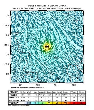
The 2014 Jinggu earthquake occurred on October 7, 2014 at 21:49 (UTC+8).
The 1990 Gonghe earthquake occurred on April 26 at 17:37 China Standard Time in Hainan Tibetan Autonomous Prefecture, Qinghai Province. The mainshock had a surface wave magnitude of 7.0 Ms and a moment magnitude of 6.5 Mw . It was presaged by two foreshocks that struck merely seconds before the main earthquake. On the Mercalli intensity scale, the earthquake had a rating of IX (Violent).
The 2021 Maduo earthquake, also known as the 5.22 earthquake struck Madoi County in Qinghai Province, China on 22 May at 02:04 local time. The earthquake had a moment magnitude and surface-wave magnitude of 7.4. Highway bridges, roads and walls collapsed as a result of the earthquake. According to an anonymous source, at least 20 people were killed, 300 were injured, and 13 were missing. Officials stated that there were no deaths but 19 people sustained minor injuries. It was the strongest in China since 2008. It was assigned a maximum intensity of X in Machali, Maduo County on the China seismic intensity scale and Modified Mercalli intensity scale. This earthquake was preceded by another unrelated earthquake that occurred 5 hours earlier in Yunnan.
The 2020 Kashgar earthquake, also known as the Jiashi earthquake occurred on 19 January 2020 at 21:27:56 China Standard Time in Xinjiang Province, China. According to the United States Geological Survey, the earthquake had a moment magnitude of 6.0 and a surface wave magnitude of 6.4 according to the China Earthquake Network Center. It struck at a shallow depth of 5.6 km according to the USGS while the CENC has the figure at 16 km. Local emergency management agencies said the earthquake damaged more than 1,000 homes and businesses in the nearby populated towns and villages. One person is known to have died while two other children were injured.
The 2021 Luxian earthquake was a damaging seismic event occurring in the early hours of September 16 at 04:33 China Standard Time. The surface wave magnitude (Ms ) 6.0 or moment magnitude (Mw ) 5.4 earthquake struck at a shallow depth of 7.5 km and severe shaking in an area of 4,000 square kilometers was assigned a maximum intensity of VIII on the China seismic intensity scale. Three people were killed and 146 injured when the earthquake struck Lu County, Luzhou, Sichuan Province. At least 36,800 buildings were affected, 7,800 of them seriously damaged or completely destroyed, causing about a quarter of a billion dollars worth of damage.

On January 8, 2022, a magnitude 6.6 earthquake struck Menyuan County, Qinghai Province near the border with Gansu Province, China. It was the largest earthquake in China since the 2021 Maduo earthquake.
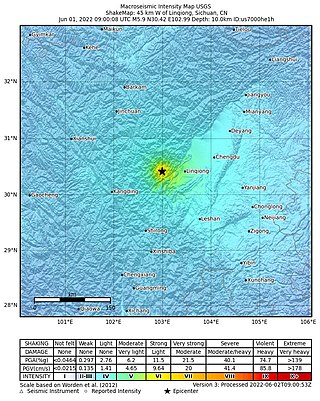
On June 1, 2022, a moment magnitude (Mw ) 5.8 or surface-wave magnitude (Ms ) 6.1 earthquake struck Lushan County in Ya'an, Sichuan Province, China. At least four people were killed and 42 were injured. The earthquake had a maximum intensity of VIII on the China seismic intensity scale, causing damage to many homes and triggering rockslides.

A 6.7 earthquake struck Luding County in Sichuan province, China on 5 September 2022 at 12:52:19 local time. The epicenter was located 226 km (140 mi) from Chengdu, or 43 km (27 mi) southeast of Kangding. Ninety-three people died, 424 were injured and 24 remained missing. More than 13,000 homes and other infrastructure were damaged or destroyed. It was the largest earthquake to strike the province since 2017.

The 2022 Taitung earthquakes were a series of two earthquakes affecting Taitung and Hualien Counties, Taiwan. The first earthquake struck Taitung on September 17, 2022, occurring with a magnitude of 6.5 Mw , causing minor damage and some injuries. The second earthquake occurred roughly a day after the first tremor struck the same area, with a stronger magnitude of 6.9 Mw . The earthquakes reached a maximum intensity of VII and IX (Violent) respectively on the Modified Mercalli Intensity Scale.

