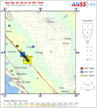
Parkfield earthquake is a name given to various large earthquakes that occurred in the vicinity of the town of Parkfield, California, United States. The San Andreas fault runs through this town, and six successive magnitude 6 earthquakes occurred on the fault at unusually regular intervals, between 12 and 32 years apart, between 1857 and 1966. The latest major earthquake in the region struck on September 28, 2004.
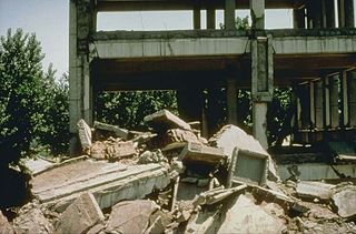
The 1976 Tangshan earthquake was a 7.6 earthquake that hit the region around Tangshan, Hebei, China, at 3:42 a.m. on 28 July 1976. The maximum intensity of the earthquake was XI (Extreme) on the Mercalli scale. In minutes, 85 percent of the buildings in Tangshan collapsed or were rendered unusable, all services failed, and most of the highway and railway bridges collapsed or were seriously damaged. The official report claimed 242,769 deaths and 164,851 serious injuries in Tangshan, but when taking into account the missing, the injured who later died and the deaths in nearby Beijing and Tianjin, scholars accepted at least 300,000 died, making it the deadliest earthquake in recorded history and one of the worst disasters in China by death toll.

Rebiya Kadeer is an ethnic Uyghur businesswoman and political activist. Born in Altay City, Xinjiang, Kadeer became a millionaire in the 1980s through her real estate holdings and ownership of a multinational conglomerate. Kadeer held various positions in the National People's Congress in Beijing and other political institutions before being arrested in 1999 for, according to Chinese state media, sending confidential internal reference reports to her husband, who worked in the United States as a pro-East Turkistan independence broadcaster. After she fled to the United States in 2005 on compassionate release, Kadeer assumed leadership positions in overseas Uyghur organizations such as the World Uyghur Congress.
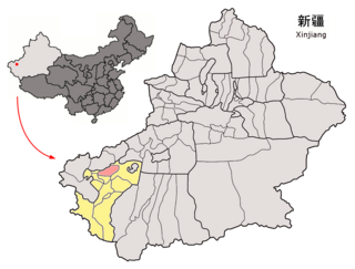
Payzawat County, also via SASM/GNC romanization as Payziwat County, and via Mandarin Chinese as Jiashi County is a county in Kashgar Prefecture, Xinjiang Uyghur Autonomous Region, China, on the western rim of the Taklamakan Desert. To the east, the county borders Maralbexi County, to the south Yopurga County.
The 2003 Bachu earthquake occurred on 24 February at 10:03 local time in the Xinjiang Autonomous Region in northwest China. The epicentre was located near to the town of Jiashi and Bachu County, approximately 105 km east of Kashgar and 310 km west of Aksu.

The 1970 Tonghai earthquake occurred at with a moment magnitude of 7.1 and a maximum Mercalli intensity of X (Extreme). The strike-slip rupture originated on the Red River Fault, which had not experienced an earthquake above magnitude 7 since 1700, and affected Tonghai County, Yunnan province, China. At least 10,000 people were killed, making it one of the deadliest in its decade. The tremor caused between US$5 and $25 million in damage, felt over an area of 8,781 km2 (3,390 sq mi). In Hanoi, North Vietnam, almost 483 km (300 mi) from the epicenter, victims left their homes as the rupture rumbled through the city.
The 1985 Wuqia earthquake occurred on August 23, 1985, at 20:42 local time near the border of Wuqia County and Shufu County, Xinjiang, China. It had a magnitude of 7.4 and caused 71 deaths, 162 injuries, and left 15,000 homeless, as well as destroying 85% of buildings and highways. The source of this earthquake is the Kazkeaerte Fault (卡兹克阿尔特断裂). The earthquake could be felt throughout much of the Fergana Basin, USSR, as well as in Pakistan.
The 1999 Oaxaca earthquake occurred on September 30 at 11:31 local time in Oaxaca, Mexico, 60 km NNW of Puerto Ángel. The epicenter was located near San Agustin Loxicha. It had a magnitude of 7.4.
An earthquake occurred on November 3 at with a magnitude 7.2, or 7.4. The epicenter was located off the Miyagi Prefecture, Japan. Four people were injured and buildings were damaged. In Isobe (磯部) village, nowadays part of Sōma, Fukushima, a small market building collapsed. A tsunami was recorded.
The 1941 Colima earthquake occurred on April 15 at 19:09 UTC. The epicenter was located in the State of Michoacán, Mexico.
The 1970 Peru–Ecuador earthquake occurred on December 9 at . The epicenter was located in northwestern Peru, between Piura and Tumbes, near the Peru–Ecuador border. This earthquake had a magnitude of 7.1, or 7.1. About 81 people were reported dead in Peru and in Ecuador together. Liquefaction was observed. The maximum Mercalli Intensity reached IX (Violent). Fractures in constructions were reported in the urban area of Talara. This was a shallow earthquake, and it was thought to occur in the plate above the plate boundary.
The 1930 North Izu earthquake occurred on . The epicenter was located in the northern Izu Peninsula, Japan. It had a magnitude of 7.3, and was caused by the movement of the Tanna Fault (丹那断層).
The 1948 Litang earthquake (1948年理塘地震) occurred on May 28, 1948, at 07:11 UTC. It was located near Litang, China. Now situated in the Sichuan Province, Litang County was then called Lihua (理化) County and belonged to the defunct Xikang Province. The earthquake had a magnitude of 7.2, or 7.3.
The 1998 Ninglang earthquake (1998年宁蒗地震) occurred on November 19 at . The epicenter was near the border between the provinces of Sichuan and Yunnan, China. The United States Geological Survey stated that the epicenter was located in the Sichuan Province, while the China Earthquake Data Center provided a different location in Lanniqing Township (烂泥箐乡), Ninglang, Yunnan Province. The magnitude of the earthquake was put at 6.2 and it caused five deaths, with 208 seriously injured in Yunnan and 20 people seriously injured in Sichuan. Building damage was reported in Ninglang, Yunnan and Yanyuan, Sichuan. A dammed lake was formed by a landslide in the Lanniqing Township.
The 1973 Luhuo earthquake struck near the town of Zhaggo in Garzê Tibetan Autonomous Prefecture of Sichuan Province, China on February 6, 1973, with a magnitude of 7.6 . The earthquake had a maximum intensity of X (Extreme) on the Modified Mercalli intensity scale. It resulted in between 2,175 and 2,204 deaths and a further 2,743 injuries. Serious and widespread destruction occurred in Luhuo County.
The 1902 Turkestan earthquake devastated Xinjiang, China, near the Kyrgyzstan border. It occurred on August 22, 1902, at 03:00:22 with an epicenter in the Tien Shan mountains. The thrust earthquake measured 7.7 on the moment magnitude scale (Mw ) and had a depth of 18 km (11 mi).
The 2020 Kashgar earthquake, also known as the Jiashi earthquake occurred on 19 January 2020 at 21:27:56 China Standard Time in Xinjiang Province, China. According to the United States Geological Survey, the earthquake had a moment magnitude of 6.0 and a surface wave magnitude of 6.4 according to the China Earthquake Network Center. It struck at a shallow depth of 5.6 km according to the USGS while the CENC has the figure at 16 km. Local emergency management agencies said the earthquake damaged more than 1,000 homes and businesses in the nearby populated towns and villages. One person is known to have died while two other children were injured.
The 1995 Menglian earthquake or 1995 Myanmar–China earthquake occurred on 12 July at 05:46:43 local time in the Myanmar–China border region. The earthquake had an epicenter on the Myanmar side of the border, located in the mountainous region of Shan State. It registered 7.3 on the Chinese surface wave magnitude scale (Ms ) and 6.8 on the moment magnitude scale (Mw ). With a maximum Mercalli intensity assigned at VIII, it killed 11 people and left another 136 injured. Over 100,000 homes in both countries were destroyed and 42,000 seriously damaged. Some damage to structures were also reported in Chiang Mai and Chiang Rai, Thailand. The low death toll from this earthquake was attributed to an early warning issued prior to it happening. Precursor events including foreshocks and some seismic anomalies led to an evacuation of the area before the mainshock struck. It is thought to be one of the few successfully predicted earthquakes in history.

The 1995 Kerinci earthquake struck near Sungai Penuh in Jambi Province on the island of Sumatra, Indonesia. It earthquake occurred at 01:18 WIB local time on October 7. The earthquake measured 6.7 on the moment magnitude scale, and 6.9–7.0 on the surface-wave magnitude scale. Between 84 and possibly even 100 people were killed in the earthquake. An extimated 4,000 buildings collapsed or were seriously damaged while a further 5,000 suffered some damage.
