
China National Highway 212 (G212) runs from Lanzhou in Gansu to Chongqing. It was originally 1302 kilometres in length. In the 2013 National Highway Network Planning it was extended to Longbang, Guangxi, on the border with Vietnam. After the extension, the length is circa 2,300 km (1,400 mi).

Pengzhou, formerly Peng County or Pengxian, is a county-level city of Sichuan Province, Southwest China, it is under the administration of the prefecture-level city of Chengdu. There is an expressway that connects Pengzhou to Chengdu. It is bordered by the prefecture-level divisions of Deyang to the northeast and the Ngawa Tibetan and Qiang Autonomous Prefecture to the north.

The Ministry of Industry and Information Technology (MIIT) is the sixth-ranked executive department of the State Council of the People's Republic of China. It is responsible for regulation and development of the postal service, Internet, wireless, broadcasting, communications, production of electronic and information goods, software industry and the promotion of the national knowledge economy.

Owing to tremendous differences in latitude, longitude, and altitude, the climate of China is extremely diverse. It ranges from tropical in the far south to subarctic in the far north, and alpine in the higher elevations of the Tibetan Plateau. Monsoon winds, caused by differences in the heat-absorbing capacity of the continent and the ocean, dominate the climate. During the summer, the East Asian Monsoon carries warm and moist air from the south and delivers the vast majority of the annual precipitation in much of the country. Conversely, the Siberian anticyclone dominates during winter, bringing cold and comparatively dry conditions. The advance and retreat of the monsoons account, in large degree, for the timing of the rainy season throughout the country. Although most of the country lies in the temperate belt, its climatic patterns are complex.

The 1920 Haiyuan earthquake occurred on December 16 in Haiyuan County, Ningxia Province, Republic of China at 19:05:53. It was also called the 1920 Gansu earthquake because Ningxia was a part of Gansu Province when the earthquake occurred. It caused destruction in the Lijunbu-Haiyuan-Ganyanchi area and was assigned the maximum intensity on the Mercalli intensity scale. About 258,707-273,407 died, making it one of the deadliest earthquakes in China and disasters in China by death toll.

The 2008 Panzhihua earthquake struck southern Sichuan province, China on August 30 at with a surface-wave magnitude of 6.1, or 6.0 . It is also cited as the Renhe-Huili earthquake, especially in SCEA reports and early CEA reports. It was not an aftershock of the Sichuan earthquake that occurred several months prior. With more than 400 aftershocks, it caused over 40 deaths, the collapse of 10,000 homes and damage to other infrastructure in the provinces of Sichuan and Yunnan. The maximum liedu was VIII.
The 2008 Yingjiang earthquakes were a series of major earthquakes ranging from surface wave magnitude (Ms) 4.1 to 5.9 that struck Yingjiang County, Yunnan province, China between August 19 and September 3. It caused 5 deaths, 130 injuries, and RMB 2.7 billion in direct economic damage. USGS put the magnitude of the strongest one to Mw 6.0.
The China Earthquake Administration is a public institution managed by the State Council at the deputy ministerial level in charge of national earthquake disaster reduction work. It is currently managed by the Ministry of Emergency Management.
The 1931 Fuyun earthquake (富蕴地震) occurred on August 10 at 21:18 UTC. The epicenter was near Fuyun County of northern Xinjiang, China. It was a 8.0 earthquake and had a surface rupture of 171 km with a maximal horizontal displacement of 14 m along the Koktokay-Ertai fault zone (可可托海-二台断裂带). The Koktokay-Ertai fault has a slip rate of 4±2 mm per year. The rupture of this earthquake was caused by right-lateral strike-slip movement with normal component. The rupture is well preserved and becomes one of the main features of the Koktokay National Geopark (可可托海国家地质公园) located in Koktokay.
On 7 September 2012, a series of earthquakes occurred in Yiliang County, Zhaotong, Yunnan. The two main shocks occurred at 11:19 and 12:16 China Standard Time. The earthquakes left 81 people dead and 821 injured. According to the officials, at least 100,000 people were evacuated and more than 20,000 houses were damaged.
The 1998 Ninglang earthquake (1998年宁蒗地震) occurred on November 19 at . The epicenter was near the border between the provinces of Sichuan and Yunnan, China. The United States Geological Survey stated that the epicenter was located in the Sichuan Province, while the China Earthquake Data Center provided a different location in Lanniqing Township (烂泥箐乡), Ninglang, Yunnan Province. The magnitude of the earthquake was put at 6.2 and it caused five deaths, with 208 seriously injured in Yunnan and 20 people seriously injured in Sichuan. Building damage was reported in Ninglang, Yunnan and Yanyuan, Sichuan. A dammed lake was formed by a landslide in the Lanniqing Township.

The Lushan earthquake or Ya'an earthquake occurred at 08:02 Beijing Time on April 20, 2013. The epicenter was located in Lushan County, Ya'an, Sichuan, about 116 km (72 mi) from Chengdu along the Longmenshan Fault in the same province heavily impacted by the 2008 Sichuan earthquake. The magnitude of the earthquake was placed at Ms 7.0 by China Earthquake Data Center, Ms 7.0 by Russian Academy of Sciences, Mw 7.0 by Geoscience Australia, Mw 6.6 by the United States Geological Survey (USGS), Mw 6.6 by the European Alert System (EMSC) and Mj 6.9 by the Japan Meteorological Agency (JMA). 1,815 aftershocks have been recorded as of 00:00 (UTC+8h) April 22.
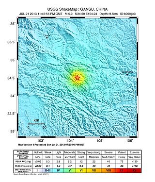
On 22 July 2013, a series of earthquakes occurred in Dingxi, Gansu. The first quake struck at 07:45 China Standard Time with an epicenter located at the border of Min County and Zhang County. The magnitude of the initial earthquake was placed at 6.6 by the China Earthquake Data Center with a focal depth of 20.0 kilometres (12 mi). It was measured at 5.9 by the United States Geological Survey (USGS) and Mw 6.0 by the European Alert System. Another strong quake occurred about one hour later, measuring 5.6 magnitude by the USGS. As of 18:00 CST, 22 July 2013, 422 aftershocks had been recorded. The earthquakes were also felt in the nearby cities of Tianshui and Lanzhou in Gansu, as well as Xi'an, Baoji, and Xianyang in neighbouring Shaanxi.

The 2014 Ludian earthquake struck Ludian County, Yunnan, China, with a moment magnitude of 6.1 on 3 August. The earthquake killed at least 615 people, injuring at least 2,400 others. At least 114 people remained missing. Over 12,000 houses collapsed and 30,000 were damaged. According to the United States Geological Survey, the earthquake occurred 29 km (18 mi) west-southwest of Zhaotong city at 16:30 local time (08:30 UTC).
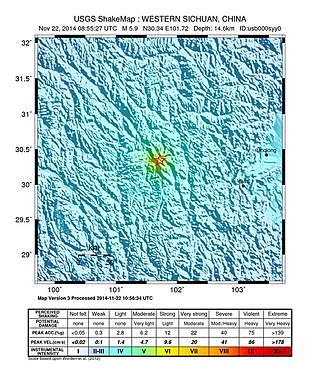
The 2014 Kangding earthquake struck Kangding County, Garzê Tibetan Autonomous Prefecture, Sichuan, China, with a moment magnitude of 5.9 on 22 November. The earthquake killed five and injured 54 people.
The 2017 Jiuzhaigou earthquake occurred on 8 August 2017, in Zhangzha Town, Jiuzhaigou County, Ngawa Prefecture, Sichuan Province, China. The earthquake was registered at 7.0 and killed at least 25 people in the mountainous region of northern Sichuan.

The 2017 Jinghe earthquake occurred at 07:27 China Standard Time on 9 August 2017, in Jinghe County, Bortala Mongol Autonomous Prefecture, Xinjiang Uyghur Autonomous Region, China, with magnitude 6.6 and depth 11 kilometres. The epicentre was 44.27°N 82.89°E. Most cities in northern Xinjiang felt the quake. This earthquake occurred on the Tian Shan seismic zone. There was no direct relationship to the earthquake in Jiuzhaigou County that occurred the previous day.

The Tsunami Advisory Center of the Ministry of National Resources is a Chinese administrative agency that aims to mitigate tsunami damage in the coastal areas of China. The agency is also known as the UNESCO Intergovernmental Oceanic Committee South China Sea Regional Tsunami Warning Center, which is abbreviated as the South China Sea Tsunami Advisory Center (SCSTAC). It was founded in 2013 and is a subsidiary of the Ministry of Natural Resources of the People's Republic of China and the National Marine Environmental Forecasting Center.
The 2021 Luxian earthquake was a damaging seismic event occurring in the early hours of September 16 at 04:33 China Standard Time. The surface wave magnitude (Ms ) 6.0 or moment magnitude (Mw ) 5.4 earthquake struck at a shallow depth of 7.5 km and severe shaking in an area of 4,000 square kilometers was assigned a maximum intensity of VIII on the China seismic intensity scale. Three people were killed and 146 injured when the earthquake struck Lu County, Luzhou, Sichuan Province. At least 36,800 buildings were affected, 7,800 of them seriously damaged or completely destroyed, causing about a quarter of a billion dollars worth of damage.

The 2019 Zigong earthquake occurred in Zigong, Sichuan Province, China, at about 13:00 on February 25, 2019. The epicentre was located in Rongxian County, with a magnitude of 4.9, a focal depth of about 5 km and a maximum intensity of VI. The earthquake killed two people and injured 12 others.
