   | |
| Local date | October 23, 1815 |
|---|---|
| Magnitude | Ms 6.8, [1] |
| Epicenter | 34°48′N111°12′E / 34.8°N 111.2°E [1] |
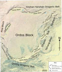
| Fault | Sanmenxia-Lingbao Fault [2] |
| Type | Normal [2] |
| Areas affected | Henan, Shanxi, Qing Dynasty |
| Max. intensity | MMI IX (Violent) [1] |
| Casualties | >13,000 dead [1] |
Western Henan and southern Shanxi in northern China were struck by an earthquake of estimated magnitude Ms 6.8 on 23 October 1815. The epicentre was in Pinglu County in southernmost Shanxi, which was the worst affected area. It had a maximum felt intensity of IX (violent) on the Modified Mercalli scale. It caused the collapse of many houses and cave dwellings and led to the deaths of at least 13,000 people. [1]