The 2000 Yunnan earthquake occurred on January 14 at 23:37 UTC, in Yunnan, China. The earthquake killed 7 people, and caused much damage in central Yunnan Province.
A 6.2 magnitude earthquake occurred in Afghanistan on October 22, 2009 at 19:51:27 UTC. The maximum Mercalli intensity was V (Moderate) at Fayzabad, Badakhshan.

The 1927 Gulang earthquake occurred at 6:32 a.m. on 22 May. This 7.6 magnitude event had an epicenter near Gulang, Gansu in the Republic of China. There were 40,912 deaths. It was felt up to 700 km (435 mi) away.
The 1932 Changma earthquake occurred at 10:04:27 local time on 25 December. With an estimated magnitude of 7.6 on the surface wave magnitude scale, and a maximum felt intensity of X (Extreme) on the Mercalli intensity scale, the quake destroyed 1,167 houses and caused 275 to 70,000 deaths and 320 injuries.
An earthquake occurred on 1 June 1786 in and around Kangding, in what is now China's Sichuan province. It had an estimated magnitude of about 7.75 and a maximum perceived intensity of X (Extreme) on the Mercalli intensity scale. The initial quake killed 435 people. After an aftershock ten days later, a further 100,000 died when a landslide dam collapsed across the Dadu river.

The Lushan earthquake or Ya'an earthquake occurred at 08:02 Beijing Time on April 20, 2013. The epicenter was located in Lushan County, Ya'an, Sichuan, about 116 km (72 mi) from Chengdu along the Longmenshan Fault in the same province heavily impacted by the 2008 Sichuan earthquake. The magnitude of the earthquake was placed at Ms 7.0 by China Earthquake Data Center, Ms 7.0 by Russian Academy of Sciences, Mw 7.0 by Geoscience Australia, Mw 6.6 by the United States Geological Survey (USGS), Mw 6.6 by the European Alert System (EMSC) and Mj 6.9 by the Japan Meteorological Agency (JMA). 1,815 aftershocks have been recorded as of 00:00 (UTC+8h) April 22.
The Zhongwei-Tongxin fault or Tianjingshan fault is an arcuate sinistral (left-lateral) strike-slip zone, forming one of the major structures on the northeastern margin of Tibetan plateau. Six paleoearthquake events in the past 14,000 years have been recorded along the Zhongwei-Tongxin fault zone. Among the earthquakes recorded are the 1622 North Guyuan earthquake, which had a magnitude of 7.0 and mid-seismogenic depth of about 15 kilometres (9.3 mi), the 1709 Zhongwei earthquake, which had a magnitude of 7.5.
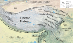
The Haiyuan Fault is a major active intracontinental strike-slip (sinistral) fault in Central Asia.
The 1973 Luhuo earthquake struck near the town of Zhaggo in Garzê Tibetan Autonomous Prefecture of Sichuan Province, China on February 6, 1973, with a magnitude of 7.6 . The earthquake had a maximum intensity of X (Extreme) on the Modified Mercalli intensity scale. It resulted in between 2,175 and 2,204 deaths and a further 2,743 injuries. Serious and widespread destruction occurred in Luhuo County.
The 2021 Maduo earthquake, also known as the 5.22 earthquake struck Madoi County in Qinghai Province, China on 22 May at 02:04 local time. The earthquake had a moment magnitude and surface-wave magnitude of 7.4. Highway bridges, roads and walls collapsed as a result of the earthquake. According to an anonymous source, at least 20 people were killed, 300 were injured, and 13 were missing. Officials stated that there were no deaths but 19 people sustained minor injuries. It was the strongest in China since 2008. It was assigned a maximum intensity of X in Machali, Maduo County on the China seismic intensity scale and Modified Mercalli intensity scale. This earthquake was preceded by another unrelated earthquake that occurred 5 hours earlier in Yunnan.
The 1995 Menglian earthquake or 1995 Myanmar–China earthquake occurred on 12 July at 05:46:43 local time in the Myanmar–China border region. The earthquake had an epicenter on the Myanmar side of the border, located in the mountainous region of Shan State. It registered 7.3 on the Chinese surface wave magnitude scale (Ms ) and 6.8 on the moment magnitude scale (Mw ). With a maximum Mercalli intensity assigned at VIII, the quake killed eleven people and left another 136 injured. Over 100,000 homes in both countries were destroyed and 42,000 seriously damaged. Some damage to structures were also reported in Chiang Mai and Chiang Rai, Thailand. The low death toll from this earthquake was attributed to an early warning issued prior to it happening. Precursor events including foreshocks and some seismic anomalies led to an evacuation of the area before the mainshock struck. It is thought to be one of the few successfully predicted earthquakes in history.
The 2021 Luxian earthquake was a damaging seismic event occurring in the early hours of September 16 at 04:33 China Standard Time. The surface wave magnitude (Ms ) 6.0 or moment magnitude (Mw ) 5.4 earthquake struck at a shallow depth of 7.5 km and severe shaking in an area of 4,000 square kilometers was assigned a maximum intensity of VIII on the China seismic intensity scale. Three people were killed and 146 injured when the earthquake struck Lu County, Luzhou, Sichuan Province. At least 36,800 buildings were affected, 7,800 of them seriously damaged or completely destroyed, causing about a quarter of a billion dollars worth of damage.

The 1695 Linfen earthquake struck Shanxi Province in North China, Qing dynasty on May 18. Occurring at a shallow depth within the continental crust, the surface-wave magnitude 7.8 earthquake had a maximum intensity of XI on the China seismic intensity scale and Mercalli intensity scale. This devastating earthquake affected over 120 counties across eight provinces of modern-day China. An estimated 52,600 people died in the earthquake, although the death toll may have been 176,365.
An earthquake occurred on June 19, 1718, in Tongwei County, Gansu Province, Qing dynasty, present-day China. The estimated surface wave magnitude (Ms ) 7.5 earthquake was designated a maximum Modified Mercalli intensity of X (Extreme), causing tremendous damage and killing 73,000 people.
The 1850 Xichang earthquake rocked Sichuan Province of Qing China on September 12. The earthquake which caused major damage in Xichang county had an estimated moment magnitude of 7.6–7.9 Mw and a surface wave magnitude of 7.5–7.7 Ms . An estimated 20,650 people died.
The 1626 Lingqiu earthquake had an epicentre in Lingqiu County, Shanxi Province during the Ming dynasty. The estimated surface wave magnitude (Ms ) 7.0 earthquake caused many buildings to collapse. Over 5,200 people were killed.
The 1923 Renda earthquake occurred on March 24 at 20:40 local time between the counties of Daofu and Luhuo in Sichuan, China. The estimated 7.3 earthquake was assigned a maximum modified Mercalli intensity scale rating of X (Extreme). Severe damage occurred in Sichuan, killing an estimated 4,800 people.
The 1955 Zheduotang earthquake, also known as the Kangding earthquake occurred on April 14 at 09:29:02 local time near the city of Kangding in the Garzê Tibetan Autonomous Prefecture, Sichuan. The earthquake had a moment magnitude of 7.0 and a surface wave magnitude of 7.1 and struck at a depth of 10 km. Severe damage occurred in Kangding with the loss of 70 lives.
The region of Ningxia was struck by a major earthquake on the morning of 14 October 1709. It had an estimated magnitude of 7.5 and a maximum felt intensity of X (extreme) on the Modified Mercalli intensity scale. The city of Zhongwei was badly damaged, including a section of the Great Wall. A total of 2,032 people were killed.
On April 11, 1870, a moment magnitude 7.3 earthquake struck Batang County in Sichuan, China. The earthquake had a maximum Modified Mercalli intensity of X (Extreme). The earthquake and a large fire resulted in between 2,300 and 5,000 fatalities.