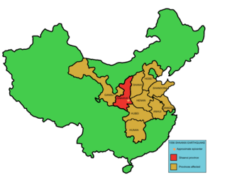
The 1556 Shaanxi earthquake, known in Chinese colloquially by its regnal year as the Jiajing Great Earthquake "嘉靖大地震" or officially by its epicenter as the Hua County Earthquake "华县地震", occurred in the early morning of 2 February 1556 in Huaxian, Shaanxi during the Ming dynasty.

The 1920 Haiyuan earthquake occurred on December 16 in Haiyuan County, Ningxia Province, Republic of China at 19:05:53. It was also called the 1920 Gansu earthquake because Ningxia was a part of Gansu Province when the earthquake occurred. It caused destruction in the Lijunbu-Haiyuan-Ganyanchi area and was assigned the maximum intensity on the Mercalli intensity scale. About 258,707-273,407 died, making it one of the deadliest earthquakes in China and disasters in China by death toll.
The 1994 Taiwan Strait earthquake occurred on 16 September 1994, at 14:20 local time in the southern Taiwan Strait. The magnitude of this earthquake was given as 6.8 by the USGS and 7.3 by Fujian Seismological Bureau. The epicenter was located about 150 to 180 km from the coast of the border of Guangdong and Fujian, and about 150 km southwest of Taiwan.
The 1948 Litang earthquake occurred on May 28, 1948, at 07:11 UTC. It was located near Litang, China. Now situated in the Sichuan Province, Litang County was then called Lihua (理化) County and belonged to the defunct Xikang Province. The earthquake had a magnitude of 7.2, or 7.3.

The 1303 Hongdong earthquake occurred in Yuan dynasty of the Mongol Empire, on September 25. The shock was estimated to have a moment magnitude of 7.6 and it had a maximum Mercalli intensity of XI (Extreme). This was one of the most deadly earthquakes in China, in turn making it one of the top disasters in China by death toll.

The Haiyuan Fault is a major active intracontinental strike-slip (sinistral) fault in Central Asia.
The 1973 Luhuo earthquake struck near the town of Zhaggo in Garzê Tibetan Autonomous Prefecture of Sichuan Province, China on February 6, 1973, with a magnitude of 7.6 . The earthquake had a maximum intensity of X (Extreme) on the Modified Mercalli intensity scale. It resulted in between 2,175 and 2,204 deaths and a further 2,743 injuries. Serious and widespread destruction occurred in Luhuo County.
A major earthquake occurred during the rule of the Qing dynasty in Shandong Province on July 25, 1668. It had an estimated magnitude of 8.5, making it the largest historical earthquake in East China, and one of the largest to occur on land. An estimated 43,000 to 50,000 people were killed, and its effects were widely felt. Its epicenter may have been located between Ju and Tancheng counties, northeast of the prefecture-level city of Linyi in southern Shandong.
The 1739 Yinchuan–Pingluo earthquake rocked the northern Ningxia Hui Autonomous Region on January 3 with an epicenter in the prefecture-level city Shizuishan. The estimated magnitude 7.1–7.6 earthquake had a maximum intensity of XI on the Mercalli intensity scale, and killed about 50,000 residents and officials. It was widely felt; perceived in Shanxi, Shaanxi and Hebei provinces. Aftershocks persisted for more than two years with the largest being a 5.5 on February 13 that same year.
The 1902 Turkestan earthquake devastated Xinjiang, China, near the Kyrgyzstan border. It occurred on August 22, 1902, at 03:00:22 with an epicenter in the Tien Shan mountains. The thrust earthquake measured 7.7 on the moment magnitude scale (Mw ) and had a depth of 18 km (11 mi).
The 2021 Maduo earthquake, also known as the 5.22 earthquake struck Madoi County in Qinghai Province, China, on 22 May at 02:04 local time. The earthquake had a moment magnitude and surface-wave magnitude of 7.4. Highway bridges, roads and walls collapsed as a result of the earthquake. According to an anonymous source, at least 20 people were killed, 300 were injured, and 13 were missing. Officials stated that there were no deaths but 19 people sustained minor injuries. It was the strongest in China since the 2008 Sichuan earthquake. It was assigned a maximum intensity of X in Machali, Maduo County on the China seismic intensity scale and Modified Mercalli intensity scale. This earthquake was preceded by another unrelated earthquake that occurred 5 hours earlier in Yunnan.
The 1695 Linfen earthquake struck Shanxi Province in North China, Qing dynasty on May 18. Occurring at a shallow depth within the continental crust, the surface-wave magnitude 7.8 earthquake had a maximum intensity of XI on the China seismic intensity scale and Mercalli intensity scale. This devastating earthquake affected over 120 counties across eight provinces of modern-day China. An estimated 52,600 people died in the earthquake, although the death toll may have been 176,365.
Western Henan and southern Shanxi in northern China were struck by an earthquake of estimated magnitude 6.8 on 23 October 1815. The epicentre was in Pinglu County in southernmost Shanxi, which was the worse affected area. It had a maximum felt intensity of IX (violent) on the Modified Mercalli scale. It caused the collapse of many houses and cave dwellings and led to the deaths of at least 13,000 people.
The Ordos Block is a crustal block, that forms part of the larger North China Block (NCB). It is surrounded by active fault systems and has been a distinct block since at least the Mesozoic. It is bordered to the west by the Alxa Block, the westernmost part of the NCB, to the south by the Qinling orogenic belt, to the north by the Yanshan-Yinshan orogenic belt, part of the Central Asian Orogenic Belt and to the east by the Taihangshan mountain range, which forms part of the Trans-North China Orogen. The block is currently stable and large earthquakes are restricted to the bordering fault zones. It has been suggested that the block is currently undergoing anti-clockwise rotation with respect to the Eurasian Plate, as a result of the ongoing eastward spreading of the Tibetan Plateau, although this view has been challenged.
The 1923 Renda earthquake occurred on March 24 at 20:40 local time between the counties of Daofu and Luhuo in Sichuan, China. The estimated 7.3 earthquake was assigned a maximum modified Mercalli intensity scale rating of X (Extreme). Severe damage occurred in Sichuan, killing an estimated 4,800 people.
The 1937 Heze earthquakes struck the Mudan District in Shandong Province, China on July 31 and August 1 respectively. The moment magnitude 7.0 and 6.7 earthquakes were centered near the city of Heze. Although the total number of casualties has never been finalized, at least 3,252 people died and 12,701 were injured. The earthquakes also killed more than 6,000 livestock and destroyed 470,000 homes. Due to the outbreak of the Second Sino-Japanese War, rescue operations by the Chinese government were ineffective.
The 1955 Zheduotang earthquake, also known as the Kangding earthquake occurred on April 14 at 09:29:02 local time near the city of Kangding in the Garzê Tibetan Autonomous Prefecture, Sichuan. The earthquake had a moment magnitude of 7.0 and a surface wave magnitude of 7.1 and struck at a depth of 10 km. Severe damage occurred in Kangding with the loss of 70 lives.
The Shanxi Rift System or Fen–Wei Rift System is a zone of active extensional tectonics that forms the eastern margin of the Ordos Block in northern China. The zone extends for at least 900 km (560 mi) and runs south-southwest to north-northeast. The individual rift basins that make up the rift system have an overall en echelon geometry, consistent with a right lateral sense of strike-slip displacement across the zone. The basins contain a thick sedimentary sequence of Neogene age, which ranges from 2.0 to 3.8 km in thickness. The rift system is continuous with the Weihe Basin to the southwest, which became active during the Paleogene. Rupture of the major normal faults that bound the Weihe and Shanxi rift basins has caused many large and damaging historical earthquakes, including the 1303 Hongdong, 1556 Shaanxi, 1626 Lingqiu, 1695 Linfen and 1815 Pinglu events.
The 1038 Dingxiang earthquake devastated present-day Shanxi Province, northern China on 9 January. At least 32,300 people died across the province when the Ms 7.25 earthquake struck Dingxiang and Xinxian counties. In Xinzhou, about 19,742 people died and 5,655 were injured. More than 50,000 livestock also perished. About 759 were killed in Guoxian County and in present-day Taiyuan, 1,890 people died.


