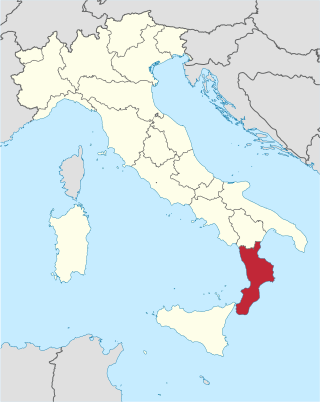
Calabria is a region in Southern Italy. It is a peninsula bordered by Basilicata to the north, the Ionian Sea to the east, the Strait of Messina to the southwest, which separates it from Sicily, and the Tyrrhenian Sea to the west. It has almost 2 million residents across a total area of 15,222 km2 (5,877 sq mi). Catanzaro is the region's capital.
The province of Catanzaro is a province of the Calabria region of Italy. The city Catanzaro is both capital of the province and capital of the region of Calabria. The province contains 80 comuni. Its provincial president is Sergio Abramo.

The 1693 Sicily earthquake was a natural disaster that struck parts of southern Italy near Sicily, then a territory part of the Crown of Aragon by the Kings of Spain Calabria and Malta, on 11 January at around 21:00 local time. This earthquake was preceded by a damaging foreshock on 9 January. The main quake had an estimated magnitude of 7.4 on the moment magnitude scale, the most powerful in recorded Italian history, and a maximum intensity of XI (Extreme) on the Mercalli intensity scale, destroying at least 70 towns and cities, seriously affecting an area of 5,600 square kilometres (2,200 sq mi) and causing the death of about 60,000 people.

The 1857 Basilicata earthquake occurred on 16 December in the Basilicata region of Italy southeast of the city of Naples. The epicentre was in Montemurro, on the western border of the modern province of Potenza. Several towns were destroyed, and there were around 11,000 fatalities according to official sources, but unofficial estimates suggest that as many as 19,000 died. At the time it was the third-largest known earthquake and has been estimated to have been of magnitude 7.0 on the moment magnitude scale.
Striking southern Italy on 8 September, the 1905 Calabria earthquake had a moment magnitude of 7.2 and a maximum Mercalli intensity of XI (Extreme). The first major earthquake of the 20th century, it severely damaged parts of Lipari, Messina Province and a large area between Cosenza and Nicotera and killed between 557 and 2,500 people.
The 1703 Apennine earthquakes were a sequence of three earthquakes of magnitude ≥6 that occurred in the central Apennines of Italy, over a period of 19 days. The epicenters were near Norcia, Montereale and L'Aquila, showing a southwards progression over about 36 kilometres (22 mi). These events involved all of the known active faults between Norcia and L'Aquila. A total of about 10,000 people are estimated to have died as a result of these earthquakes, although because of the overlap in areas affected by the three events, casualty numbers remain highly uncertain.
The 1783 Calabrian earthquakes were a sequence of five strong earthquakes that hit the region of Calabria in southern Italy, the first two of which produced significant tsunamis. The epicenters form a clear alignment extending nearly 100 km from the Straits of Messina to about 18 km SSW of Catanzaro. The epicenter of the first earthquake occurred in the plain of Palmi. The earthquakes occurred over a period of nearly two months, all with estimated magnitudes of 5.9 or greater. Estimates of the total number of deaths lie in the range 32,000 to 50,000.
The 1968 Belice earthquake sequence took place in Sicily between 14 and 15 January. The largest shock measured 5.5 on the moment magnitude scale, with five others of magnitude 5+. The maximum perceived intensity was X (Extreme) on the Mercalli intensity scale. The earthquake sequence, centred between the towns of Gibellina, Salaparuta and Poggioreale, killed at least 231 people, possibly more than 400, with between 632 and about 1,000 injured and left 100,000 homeless. It is known in Italy as Terremoto del Belice.
On 5 February AD 62, an earthquake of an estimated magnitude of between 5 and 6 and a maximum intensity of IX or X on the Mercalli scale struck the towns of Pompeii and Herculaneum, severely damaging them. The earthquake may have been a precursor to the eruption of Mount Vesuvius in AD 79, which destroyed the same two towns. The contemporary philosopher and dramatist Seneca the Younger wrote an account of the earthquake in the sixth book of his Naturales quaestiones, entitled De Terrae Motu.
The 1930 Senigallia earthquake struck the city of Senigallia in central Italy on 30 October. It occurred just a few months after the destructive 1930 Irpinia earthquake, which had caused over 1,400 casualties in the southern part of the country.
The 1936 Cansiglio earthquake occurred on 18 October in the region between the provinces of Belluno, Treviso and Pordenone, in northern Italy. It caused 19 deaths and an unknown number of injuries.

In May 2012, two major earthquakes struck Northern Italy, causing 27 deaths and widespread damage. The events are known in Italy as the 2012 Emilia earthquakes, because they mainly affected the Emilia region.
The 1169 Sicily earthquake occurred on 4 February 1169 at 08:00 local time on the eve of the feast of St. Agatha of Sicily. It had an estimated magnitude of between 6.4 and 7.3 and an estimated maximum perceived intensity of X (Extreme) on the Mercalli intensity scale. The cities of Catania, Lentini and Modica were severely damaged, and the earthquake also triggered a paleotsunami. Overall, the earthquake is estimated to have caused the deaths of at least 15,000 people.
The 141 Lycia earthquake occurred in the period AD 141 to 142. It affected most of the Roman provinces of Lycia and Caria and the islands of Rhodes, Kos, Simi and Serifos. It triggered a severe tsunami which caused major inundation. The epicenter for this earthquake is not well constrained, with locations suggested at the northern end of Rhodes, on the Turkish mainland north of Rhodes near Marmaris and beneath the sea to the east of Rhodes.
The 1511 Idrija earthquake occurred on 26 March 1511 with a moment magnitude of 6.9 and a maximum EMS intensity of X. The epicenter was near the town of Idrija, although some place it in Friuli. The earthquake affected a large territory between Carinthia, Friuli, present-day Slovenia and Croatia. An estimated 3,000 people were killed and damage was considered severe. The earthquake was felt as far as in Switzerland and present-day Slovakia. A number of castles and churches were razed to the ground in a large area from northeast Italy to western Croatia.

The 1883 Casamicciola earthquake, also known as the Ischia earthquake occurred on 28 July at 20:25 local time on the island of Ischia in the Gulf of Naples in Italy. Although the earthquake had an estimated moment magnitude of 4.2–5.5, considered moderate in size, it caused intense ground shaking that was assigned XI (Extreme) on the Modified Mercalli intensity scale. Between 2,313 and 3,100 people lost their lives. The city also suffered great property losses, with 80 percent of all homes destroyed. This earthquake was exceptionally destructive for its magnitude mainly due to its shallow focal depth.

The 1626 Lingqiu earthquake had an epicentre in Lingqiu County, Shanxi Province during the Ming dynasty. The estimated surface wave magnitude (Ms ) 7.0 earthquake caused many buildings to collapse. Over 5,200 people were killed.
A series of mainshocks struck Calabria on March 27–28 and June 9, 1638. The first three earthquakes had moment magnitudes estimated to be 6.6–7.1. On June 9, another mainshock estimated at Mw 6.7 struck the same region, causing further damage and casualties. The four earthquakes resulted in as many as 30,000 fatalities.
