
Vittorio Veneto is a city and comune situated in the Province of Treviso, in the region of Veneto, Italy, in the northeast of Italy, between the Piave and the Livenza rivers, borders with the following municipalities:
Cordignano is a comune (municipality), with 7,020 inhabitants, in the province of Treviso, in the Italian region of Veneto.

Mussolente is a town in the province of Vicenza, Veneto, northern Italy. It is north of SS248 state road.
The Giardino Botanico Alpino "Giangio Lorenzoni" is an alpine botanical garden located in Pian di Cansiglio, Boral del Giaz, Tambre d'Alpago, Province of Belluno, Veneto, Italy. It is open daily in the warmer months.
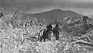
The 1915 Avezzano earthquake or 1915 Fucino earthquake occurred on 13 January in central Italy at . The shock had a moment magnitude of 6.7 and a maximum Mercalli intensity of XI (Extreme). The epicenter was located in the city of Avezzano in the Province of L'Aquila. Around 30,000 direct fatalities and $60 million in damage resulted from the earthquake.
The 1920 Garfagnana earthquake occurred on 7 September in Garfagnana and Lunigiana, both agricultural areas in the Italian Tuscany region. The quake hypocenter was located 14 kilometres (8.7 mi) beneath Villa Collemandina. The maximum felt intensity was rated as X (Extreme) on the Mercalli intensity scale, and 6.6 on the Richter scale. It was one of the most destructive seismic events recorded in the Apenninic region in the twentieth century. Due to good news coverage, availability of official documents on the damage and abundance of recordings from surveillance stations throughout Europe, it was regarded as a first-rate case study to improve knowledge of tectonics and macroseismic analysis.
The 1930 Senigallia earthquake struck the city of Senigallia in central Italy on 30 October. It occurred just a few months after the destructive 1930 Irpinia earthquake, which had caused over 1,400 casualties in the southern part of the country.
The 1873 Alpago earthquake occurred near the Italian city of Belluno on 29 June in the geologically active Alpago Valley of the Veneto region; the zone is rated as two on a four-degree risk scale. The 6.3 magnitude quake was rated as IX–X (Violent–Extreme) on the Mercalli intensity scale. Intensities greater than VII were confined to the provinces of Belluno, Treviso and Pordenone.

In May 2012, two major earthquakes struck Northern Italy, causing 27 deaths and widespread damage. The events are known in Italy as the 2012 Emilia earthquakes, because they mainly affected the Emilia region.

Cansiglio is a plateau in the northern-Italian Prealps, included in the provinces of Belluno, Treviso and Pordenone. Cansiglio is home to a very small Language island of Cimbrian.

An earthquake, measuring 6.2 ± 0.016 on the moment magnitude scale, hit Central Italy on 24 August 2016 at 03:36:32 CEST. Its epicentre was close to Accumoli, with its hypocentre at a depth of 4 ± 1 km, approximately 75 km (47 mi) southeast of Perugia and 45 km (28 mi) north of L'Aquila, in an area near the borders of the Umbria, Lazio, Abruzzo and Marche regions. As of 15 November 2016, 299 people had been killed.

A series of major earthquakes struck Central Italy between the Marche and Umbria regions in October 2016. The third quake on 30 October was the largest in Italy in 36 years, since the 1980 Irpinia earthquake.
The 1639 Amatrice earthquake occurred on 7 October near Amatrice, in the upper valley of the river Tronto, at the time part of the Kingdom of Naples, now Italy.
The 1688 Sannio earthquake occurred in the late afternoon of June 5 in the province of Benevento of southern Italy. The moment magnitude is estimated at 7.0, with a Mercalli intensity of XI. It severely damaged numerous towns in a vast area, completely destroying Cerreto Sannita and Guardia Sanframondi. The exact number of victims is unknown, although it is estimated to total approximately 10,000. It is among the most destructive earthquakes in the history of Italy.

The 1883 Casamicciola earthquake, also known as the Ischia earthquake occurred on 28 July at 20:25 local time on the island of Ischia in the Gulf of Naples in Italy. Although the earthquake had an estimated moment magnitude of 4.2–5.5, considered moderate in size, it caused intense ground shaking that was assigned XI (Extreme) on the Modified Mercalli intensity scale. Between 2,313 and 3,100 people lost their lives. The city also suffered great property losses, with 80 percent of all homes destroyed. This earthquake was exceptionally destructive for its magnitude mainly due to its shallow focal depth.
On December 5, 1456, the largest earthquake to occur on the Italian Peninsula in historical times struck the Kingdom of Naples. The earthquake had an estimated moment magnitude of Mw 7.19–7.4, and was centred near the town of Pontelandolfo in the present-day Province of Benevento, southern Italy. Earning a level of XI (Extreme) on the Modified Mercalli intensity scale, the earthquake caused widespread destruction in central and southern Italy. Estimates of the death toll range greatly with up to 70,000 deaths reported. It was followed by two strong Mw 7.0 and 6.0 earthquakes to the north on December 30. The earthquake sequence is considered the largest in Italian history, and one of the most studied.
A series of mainshocks struck Calabria on March 27–28 and June 9, 1638. The first three earthquakes had moment magnitudes estimated to be 6.6–7.1. On June 9, another mainshock estimated at Mw 6.7 struck the same region, causing further damage and casualties. The four earthquakes resulted in as many as 30,000 fatalities.
The 1706 Abruzzo earthquake, also known as the Maiella earthquake, occurred on November 3 at 13:00 CEST. The earthquake with a possible epicenter in the Central Apennine Mountains (Maiella), Abruzzo had an estimated moment magnitude of 6.6–6.84 Mw . It was assigned a maximum Mercalli intensity of XI (Extreme), causing tremendous destruction in Valle Peligna. At least 2,400 people were killed.
The 1743 Salento earthquake affected the Apulian region of southwestern Italy on 20 February at 23:30 IST. The ~7.1 Mw earthquake had an epicenter in the Adriatic and Ionian seas, off the coast of modern-day Lecce and Brindisi provinces in Salento. It had a maximum Modified Mercalli intensity of IX (Violent), causing heavy damage in Nardò. Damage was also reported across the sea, in the Balkans. The earthquake also generated a tsunami of up to 11 meters in run-up. Between 180 and 300 people were killed in the disaster.
In 1916, two earthquakes of magnitude 5.82 occurred near the border between the regions of Romagna and the Marche in the Kingdom of Italy: at 13:50 CEST on 17 May, and at 09:06 CEST on 16 August.
