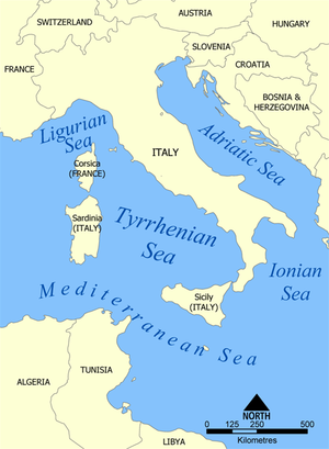
The Tyrrhenian Sea is part of the Mediterranean Sea off the western coast of Italy. It is named for the Tyrrhenian people identified with the Etruscans of Italy.

The Aeolian Islands, sometimes referred to as the Lipari Islands or Lipari group after their largest island, are a volcanic archipelago in the Tyrrhenian Sea north of Sicily, said to be named after Aeolus, the mythical ruler of the winds. The islands' inhabitants are known as Aeolians. The islands had a permanent population of 14,224 at the 2011 census; the latest official estimate is 15,419 as of 1 January 2019. The Aeolian Islands are a popular tourist destination in the summer and attract up to 600,000 visitors annually.

Amalfi is a town and comune in the province of Salerno, in the region of Campania, Italy, on the Gulf of Salerno. It lies at the mouth of a deep ravine, at the foot of Monte Cerreto, surrounded by dramatic cliffs and coastal scenery. The town of Amalfi was the capital of the maritime republic known as the Duchy of Amalfi, an important trading power in the Mediterranean between 839 and around 1200.

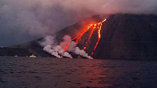
Stromboli is an island in the Tyrrhenian Sea, off the north coast of Sicily, containing Mount Stromboli, one of the four active volcanoes in Italy. It is one of the seven Aeolian Islands, a volcanic arc north of Sicily, and the mythological home of Aeolus.

The volcanism of Italy is due chiefly to the presence, a short distance to the south, of the boundary between the Eurasian Plate and the African Plate. Italy is a volcanically active country, containing the only active volcanoes in mainland Europe. The lava erupted by Italy's volcanoes is thought to result from the subduction and melting of one plate below another.

The Amalfi Coast is a stretch of coastline in southern Italy overlooking the Tyrrhenian Sea and the Gulf of Salerno. It is located south of the Sorrentine Peninsula and north of the Cilentan Coast.

The Sorrento Peninsula or Sorrentine Peninsula is a peninsula located in southern Italy which separates the Gulf of Naples to the north from the Gulf of Salerno to the south.

The Gulf of Naples, also called the Bay of Naples, is a roughly 15-kilometer-wide (9.3 mi) gulf located along the south-western coast of Italy. It opens to the west into the Mediterranean Sea. It is bordered on the north by the cities of Naples and Pozzuoli, on the east by Mount Vesuvius, and on the south by the Sorrento Peninsula and the main town of the peninsula, Sorrento. The Peninsula separates the Gulf of Naples from the Gulf of Salerno, which includes the Amalfi Coast.

The Gulf of Salerno is a gulf of the Tyrrhenian Sea in the coast of the province of Salerno in south-western Italy.

The Duchy of Amalfi or the Republic of Amalfi was a de facto independent state centered on the Southern Italian city of Amalfi during the 10th and 11th centuries. The city and its territory were originally part of the larger ducatus Neapolitanus, governed by a patrician, but it extracted itself from Byzantine vassalage and first elected a duke in 958.

Scilla is a town and comune in Calabria, Italy, administratively part of the Metropolitan City of Reggio Calabria. It is the traditional site of the sea monster Scylla of Greek mythology.

Atrani is a city and comune on the Amalfi Coast in the province of Salerno in the Campania region of south-western Italy. It is located to the east of Amalfi, several minutes' drive down the coast.

The maritime republics, also called merchant republics, were Italian thalassocratic port cities which, starting from the Middle Ages, enjoyed political autonomy and economic prosperity brought about by their maritime activities. The term, coined during the 19th century, generally refers to four Italian cities, whose coats of arms have been shown since 1947 on the flags of the Italian Navy and the Italian Merchant Navy: Amalfi, Genoa, Pisa, and Venice. In addition to the four best known cities, Ancona, Gaeta, Noli, and, in Dalmatia, Ragusa, are also considered maritime republics; in certain historical periods, they had no secondary importance compared to some of the better known cities.

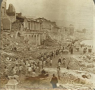
A devastating earthquake occurred on 28 December 1908 in Sicily and Calabria, southern Italy with a moment magnitude of 7.1 and a maximum Mercalli intensity of XI (Extreme). The epicentre was in the Strait of Messina which separates Sicily from the Italian mainland. The cities of Messina and Reggio Calabria were almost completely destroyed and between 75,000 and 82,000 people died, making it the deadliest earthquake in the history of Europe.
Striking southern Italy on 8 September, the 1905 Calabria earthquake had a moment magnitude of 7.2 and a maximum Mercalli intensity of XI (Extreme). The first major earthquake of the 20th century, it severely damaged parts of Lipari, Messina Province and a large area between Cosenza and Nicotera and killed between 557 and 2,500 people.
The 1692 Jamaica earthquake struck Port Royal, Jamaica, on 7 June. A stopped pocket watch found in the harbor during a 1959 excavation indicated that it occurred around 11:43 AM local time.

The 2002 Stromboli tsunami was a tsunami caused by a volcanic eruption on the island of Stromboli, in the Aeolian Islands of Sicily, located on the Tyrrhenian Sea. In May 2002, one of the island's two active volcanoes, called Stromboli, entered a new phase of explosive activity that was initially characterized by gas and ash emission from the summit craters. On 30 December 2002, the seismic network recorded two large collapses of a huge portion of the Sciara del Fuoco, which resulted in the tsunamis. The first landslide was around 13:15 and the second one around 13:23, which lasted for 5–7 minutes. The event caused damages on the eastern coast side of Stromboli and Panarea. These tsunamis have been considered the most violent ones to have struck Stromboli in the past 100 years.
On December 5, 1456, the largest earthquake to occur on the Italian Peninsula struck the Kingdom of Naples. The earthquake had an estimated moment magnitude of Mw 7.19–7.4, and was centred near the town of Pontelandolfo in the present-day Province of Benevento, southern Italy. Earning a level of XI (Extreme) on the Modified Mercalli intensity scale, the earthquake caused widespread destruction in central and southern Italy. Estimates of the death toll range greatly with as many as 70,000 deaths reported. It was followed by two strong Mw 7.0 and 6.0 earthquakes to the north on December 30. The earthquake sequence is considered the largest in Italian history, and one of the most studied.
A series of mainshocks struck Calabria on March 27–28 and June 9, 1638. The first three earthquakes had moment magnitudes estimated to be 6.6–7.1. On June 9, another mainshock estimated at Mw 6.7 struck the same region, causing further damage and casualties. The four earthquakes resulted in as many as 30,000 fatalities.
The 1743 Salento earthquake affected the Apulian region of southwestern Italy on 20 February at 23:30 IST. The ~7.1 Mw earthquake had an epicenter in the Adriatic and Ionian seas, off the coast of modern-day Lecce and Brindisi provinces in Salento. It had a maximum Modified Mercalli intensity of IX (Violent), causing heavy damage in Nardò. Damage was also reported across the sea, in the Balkans. The earthquake also generated a tsunami of up to 11 meters in run-up. Between 180 and 300 people were killed in the disaster.


