2012 Northern Italy earthquakes

Last updated

2012 Northern Italy earthquakes
2012 Modena intensity.jpg
USGS 20 May intensity map
Italy relief location map.jpg
Bullseye1.png
UTC  time 
 2012-05-20 02:03:53
 2012-05-29 07:00:03
ISC  event 
  601025379
  605482196
USGS-ANSS  
  ComCat
  ComCat
Local date 
 20 May 2012
 29 May 2012
Local time 
 04:03
 09:00
Magnitude6.1 Mw
 5.8 Mw
Depth5.6 km (3.5 mi)
Epicenter 44°54′N11°14′E / 44.9°N 11.24°E / 44.9; 11.24
Type Thrust
Areas affected Emilia-Romagna, Italy
Max. intensity VIII (Severe)
Casualties27 dead (7 on 20 May and 20 on 29 May), at least 50 injured in the first quake and 350 in the second, up to 45,000 homeless in total [1] [2]

In May 2012, two major earthquakes struck Northern Italy, causing 27 deaths and widespread damage. The events are known in Italy as the 2012 Emilia earthquakes, because they mainly affected the Emilia region.

Contents

The first earthquake, registering magnitude 6.1, struck in the Emilia-Romagna region, about 36 kilometres (22 miles) north of the city of Bologna, on 20 May at 04:03 local time (02:03 UTC). The epicentre was between Finale Emilia, Bondeno and Sermide. Two aftershocks of magnitude 5.2 occurred, one approximately an hour after the main event [3] and another approximately eleven hours after the main event. [4] Seven people were killed.

A magnitude 5.8 earthquake struck the same area nine days later, on 29 May, causing an additional twenty deaths and widespread damage, particularly to buildings already weakened by the 20 May earthquake. [5] The epicentre was in Medolla: the quake itself occurred at a depth of about 10 kilometres (6.2 mi). [6]

Tectonic setting

The Po Plain, a foreland basin formed by the downflexing of the crust by the loading of the Apennine thrust sheets, overlies and mainly conceals the active front of the Northern Apennines fold and thrust belt, across which there is about one millimeter (0.04 in) per year of active shortening at present. Information from hydrocarbon exploration demonstrates that the area is underlain by a series of active thrust faults and related folds, some of which have been detected from anomalous drainage patterns. These blind thrust faults are roughly WNW–ESE trending, parallel to the mountain front, and dip shallowly towards the south-southwest. Several damaging historical earthquakes, such as the 1570 Ferrara earthquake, have occurred in the area. [7]

Earthquake sequence

The damaged church of Saint Paul in Mirabello, Ferrara. Chiesa di San Paolo - Mirabello - Province of Ferrara - 2012 Northern Italy earthquake - (1).jpg
The damaged church of Saint Paul in Mirabello, Ferrara.

The 20 May earthquake sequence began with a magnitude 4.0 foreshock at 01:13 local time (23:13 UTC 19 May). Less than three hours later, at 04:04 local time (02:04 UTC) the biggest of these earthquakes occurred with magnitude 6.1 between Finale Emilia (province of Modena) and Sant'Agostino (province of Ferrara). This strong quake destroyed all the churches and many of the factories in the area. Seven people were killed. In San Carlo more than 350 families lost their houses. Within the next nine days, there were six aftershocks exceeding magnitude 5, 28 of magnitude 4–5 and 139 of magnitude 3–4. [8] The mainshock could be felt as far away as Switzerland. [9] The focal mechanism indicates that the earthquake was a result of thrust faulting, [10] with a north–south direction of compression, on a fault plane trending west–east. This type of faulting is consistent with the regional tectonic setting. [11]

On 29 May (about 09:00 CEST, 07:00 UTC), a magnitude 5.8 earthquake hit the same area. The hypocentre has been estimated at 5–10 kilometres (3–6 mi) below Mirandola. [12] A series of two or three, according to different sources, strong aftershocks with magnitudes larger than 5 occurred at between 12:55 and 13:02 local time. [13] [14] The 09:00 shock and the 13:00 shocks were felt throughout Northern Italy, up to the Aosta province. [15] The 09:00 earthquake was also felt in Austria, Switzerland, [9] Slovenia and Croatia, [16] with reports of swaying buildings in Austria. The two large aftershocks at 12:55 and 13:02 could also be felt in Austria. [14] This earthquake had a similar mechanism to the 20 May shock. [17]

This earthquake, like the previous earthquake of 20 May, was distinctly felt in Trentino Alto Adige. It was especially felt on the upper floors of buildings both in Trento and Bolzano, and created some concern among residents. [18]

Sequence of shocks
Date CEST Mw IDepth (km)Region
20 May04:03:536.1VII10 Finale Emilia
29 May09:00:035.8VII5 MedollaCavezzo
29 May12:55:565.5VI2 San PossidonioMirandola
European-Mediterranean Seismological Centre

On 6 June at 06:08 local time, a magnitude 4.5 earthquake hit 50 km further east with an epicenter off the coast of Ravenna in Romagna at a depth 25.6 km. [19] The earthquake was felt strongly and distinctly in Ravenna and Rimini, then less in Pesaro and Ancona, and very slightly in the province of Modena, in areas already affected by earthquakes in recent days. This earthquake was generated by a fault other than that responsible for the earthquakes of 20 and 29 May in Emilia, although part of the same group of geological structures. [20]

Damage

A destroyed house in Cento Pilastrello (frazione di Cento) - Province of Ferrara - 2012 Northern Italy earthquake.jpg
A destroyed house in Cento

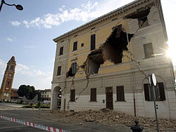
Initial reports after the 20 May shock listed seven dead, including four workers at a factory in Ferrara, [1] and about 5,000 people left homeless. [21] At least 100 structures of historical significance have been damaged or destroyed. Many churches in towns around the epicentre suffered damage. [21] [22] One of the towers of Castello Estense, a moated medieval structure in the centre of Ferrara, was damaged in the earthquake. [23] Half of a clock tower in Finale Emilia dating from the 13th century (known as the torre dei modenesi) fell down in the mainshock and the remaining part collapsed completely during an aftershock later that day. There was also significant damage to factories and agricultural land in the region. [24]

Production of Grana Padano and Parmigiano-Reggiano hard cheeses was badly affected; approximately 300,000 wheels, with an estimated value of €200 million, were destroyed. [25]

The damaged town hall of Sant'Agostino. Al Munisipi ad Sant Agusten.jpg
The damaged town hall of Sant'Agostino.

Five of the deaths were caused by the collapse of recently constructed factory buildings. Stefano Gresta, president of the National Institute of Geophysics and Volcanology, deemed it "unacceptable that modern constructions such as warehouses and industrial sheds have collapsed in an earthquake which was strong, but not exceptional". [26] The area was not included in seismic hazard maps until 2003, when, after a reassessment, it was classified as "medium risk", with a 10% likelihood of such an earthquake in the next 450 years. A law introduced in 2006 imposed building standards appropriate for the seismic hazard classification, but few of the older buildings have been upgraded to meet these requirements. [26]

The 29 May magnitude 5.8 earthquake left 18 people dead, more than 350 injured, and more than 15,000 homeless. [27] The roof of the 15th-century cathedral of Mirandola, already damaged on 20 May, collapsed after the 29 May shock. [28] The earthquake was felt in most of Northern Italy, triggering evacuation of schools and other buildings. Some buildings in the Modena province and neighbouring areas, already damaged in the first earthquake, collapsed. [12]

The damaged church of Saint Martin of Tours in Cento, Ferrara. Chiesa San Martino di Tours - Buonacompra frazione di Cento, Ferrara - 2012 Northern Italy earthquake.jpg
The damaged church of Saint Martin of Tours in Cento, Ferrara.

After the mainshock of 20 May, inspections were underway to determine which buildings were safe to reenter. The 29 May earthquake occurred during the daytime, when many people were working. As in the mainshock of 20 May, many of the dead in the 29 May earthquake were workers inside huge warehouses and factories. A local union representative has demanded an investigation to determine who was responsible for permitting the companies to resume operations. [29]

Both the 20 and 29 May events caused damage to the neighbouring provinces of Bologna, Reggio Emilia, Rovigo and Mantua, where parts of the ducal palace were damaged. [30]

An aftershock on the 3 June was felt throughout Northern Italy and caused the collapse of the 18th century clock tower in Novi di Modena, already imperilled by the earthquake of recent days. [31]

The earthquake damage in Emilia "could exceed 4 billion" according to the vice-president of Confindustria Emilia-Romagna, Gaetano Maccaferri, who released these figures in testimony before the Senate Committee on Industry. [32]

See also

Related Research Articles

<span class="mw-page-title-main">San Felice sul Panaro</span> Comune in Emilia-Romagna, Italy

San Felice sul Panaro is a comune (municipality) in the province of Modena in the Italian region Emilia-Romagna, located about 40 kilometres (25 mi) northwest of Bologna and about 25 kilometres (16 mi) northeast of Modena.

Two earthquakes hit the Italian regions of Molise and Apulia on 31 October at 10:32:58 (UTC) and 1 November at 15:09:00 (UTC). The shocks had magnitudes of 5.9 and 5.8 Mw respectively. Most of the victims were killed and injured when a school collapsed in the town of San Giuliano di Puglia: 26 of the 51 schoolchildren died, together with one of their teachers. In particular, none of the nine children in the school's 4th Year survived.

The 1952 Kern County earthquake occurred on July 21 in the southern San Joaquin Valley and measured 7.3 on the moment magnitude scale. The main shock occurred at 4:52 am Pacific Daylight Time, killed 12 people, injured hundreds more and caused an estimated $60 million in property damage. A small sector of damage near Bealville corresponded to a maximum Mercalli intensity of XI (Extreme), though this intensity rating was not representative of the majority of damage. The earthquake occurred on the White Wolf Fault near the community of Wheeler Ridge and was the strongest to occur in California since the 1906 San Francisco earthquake.

<span class="mw-page-title-main">2009 L'Aquila earthquake</span> Earthquake in Abruzzo, Italy

The 2009 L'Aquila earthquake occurred in the region of Abruzzo, in central Italy. The main shock occurred at 03:32 CEST on 6 April 2009, and was rated 5.8 or 5.9 on the Richter magnitude scale and 6.3 on the moment magnitude scale; its epicentre was near L'Aquila, the capital of Abruzzo, which together with surrounding villages suffered the most damage. There have been several thousand foreshocks and aftershocks since December 2008, more than thirty of which had a Richter magnitude greater than 3.5.

The 1968 Belice earthquake sequence took place in Sicily between 14 and 15 January. The largest shock measured 5.5 on the moment magnitude scale, with five others of magnitude 5+. The maximum perceived intensity was X (Extreme) on the Mercalli intensity scale. The earthquake sequence, centred between the towns of Gibellina, Salaparuta and Poggioreale, killed at least 231 people, possibly more than 400, with between 632 and about 1,000 injured and left 100,000 homeless. It is known in Italy as Terremoto del Belice.

The 1985 Rapel Lake earthquake occurred on 8 April at 21:56:59 local time with a moment magnitude of 7.5 and a maximum perceived intensity of VI (Strong). The shock was centered 75 kilometres (47 mi) southwest of Santiago, Chile, with a focal depth of 37.8 km (23 mi).

The 1920 Garfagnana earthquake occurred on 7 September in Garfagnana and Lunigiana, both agricultural areas in the Italian Tuscany region. The quake hypocenter was located 14 kilometres (8.7 mi) beneath Villa Collemandina. The maximum felt intensity was rated as X (Extreme) on the Mercalli intensity scale, and 6.6 on the Richter magnitude scale. It was one of the most destructive seismic events recorded in the Apenninic region in the twentieth century. Due to good news coverage, availability of official documents on the damage and abundance of recordings from surveillance stations throughout Europe, it was regarded as a first-rate case study to improve knowledge of tectonics and macroseismic analysis.

<span class="mw-page-title-main">August 2016 Central Italy earthquake</span> 6.2 magnitude earthquake

An earthquake, measuring 6.2 ± 0.016 on the moment magnitude scale, hit Central Italy on 24 August 2016 at 03:36:32 CEST. Its epicentre was close to Accumoli, with its hypocentre at a depth of 4 ± 1 km, approximately 75 km (47 mi) southeast of Perugia and 45 km (28 mi) north of L'Aquila, in an area near the borders of the Umbria, Lazio, Abruzzo and Marche regions. As of 15 November 2016, 299 people had been killed.

<span class="mw-page-title-main">October 2016 Central Italy earthquakes</span>

A series of major earthquakes struck Central Italy between the Marche and Umbria regions in October 2016. The third quake on 30 October was the largest in Italy in 36 years, since the 1980 Irpinia earthquake.

The 2017 Ischia earthquake occurred in the island of Ischia, Campania, in southern Italy. The main shock occurred at 20:57 CEST on 21 August 2017, and was rated 3.9 Mw  or 4.2 mb  on the moment magnitude scale.

The 1992 Murindó earthquake occurred on October 18 at 15:11 UTC with an epicenter in the Department of Chocó, northern Colombia. The shallow magnitude 7.2 earthquake struck northwest of the town of Murindó, killing ten and injured more than a hundred. Thirty-three municipalities were severely damaged.

<span class="mw-page-title-main">2018 Hawaii earthquake</span> 6.9-magnitude earthquake in Hawaii

On May 4, 2018, an earthquake with a magnitude of Mw 6.9 struck Hawaii island in the Hawaii archipelago at around 12:33 p.m. local time. The earthquake's epicenter was near the south flank of Kīlauea, which has been the site of seismic and volcanic activity since late April of that year. According to the United States Geological Survey the quake was related to the new lava outbreaks at the volcano, and it resulted in the Hilina Slump moving about two feet. It was the largest earthquake to affect Hawaii since the 1975 earthquake, which affected the same region, killing two people and injuring another 28.

<span class="mw-page-title-main">2018 Haiti earthquake</span> 5.9 magnitude earthquake in Port-de-Paix, Haiti

On October 6, 2018, at approximately 8:11 p.m, a magnitude 5.9 earthquake struck 19 kilometers northwest of Port-de-Paix, Haiti. The earthquake damaged structures and killed 18 people.

<span class="mw-page-title-main">2013 Craig, Alaska earthquake</span> Earthquake in Alaska and British Columbia

The 2013 Craig, Alaska earthquake struck on January 5, at 12:58 am (UTC–7) near the city of Craig and Hydaburg, on Prince of Wales Island. The Mw 7.5 earthquake came nearly three months after an Mw  7.8 quake struck Haida Gwaii on October 28, in 2012. The quake prompted a regional tsunami warning to British Columbia and Alaska, but it was later cancelled. Due to the remote location of the quake, there were no reports of casualties or damage.

The 1833 Nepal–India earthquake occurred on August 26 at 22:58 local time (NPT). This earthquake had an estimated moment magnitude of 7.6–7.9 and struck with an epicenter somewhere in or near the Kathmandu Valley. The earthquake caused major destruction in numerous towns and villages in Nepal, northern India, and Tibet. The earthquake was also felt in Chittagong, Bangladesh. Despite the extent of the damage, the number of fatalities resulting from the earthquake was surprisingly low, at approximately 500. This was because the mainshock was preceded by two smaller but intense foreshocks earlier that day, causing many residents to take refuge outside their homes.

The 1902 Turkestan earthquake devastated Xinjiang, China, near the Kyrgyzstan border. It occurred on August 22, 1902, at about 8:00 or 9:00 am local time with an epicenter near the Tien Shan mountains. The thrust earthquake measured 7.7 on the moment magnitude scale (Mw ) and initiated at a depth of 18 km (11 mi). The Tien Shan mountains is situated in a zone of complex convergence caused by the Indian–Eurasian plate interaction. This zone is actively deforming—accommodated by active thrust faults responsible for seismic activity. The mainshock was preceded by an intense series of foreshocks in the years prior. Many aftershocks followed, several were larger than magnitude 6.0 and one measured magnitude 6.8–7.3. These aftershocks were recorded for three years. Additional shocks were recorded over a decade after the mainshock. An estimated 5,650–10,000 people were killed in the mainshock. Widespread destruction occurred—at least 30,000 homes were destroyed. Shaking was felt across an area of 927,000 km2 (358,000 sq mi). The effects of the earthquake led government officials to relieve victims of taxes and provide compensation.

The 1990 Carlentini earthquake occurred off the Sicilian coast, 20 km east northeast from the town of Augusta, Sicily on 13 December at 01:24 local time. The moderately-sized earthquake measuring 5.6 on the moment magnitude scale (Mw ) resulted in the deaths of 19 people and caused at least 200 injuries. It also inflicted significant damage in the region, leaving 2,500 homeless.

The 2016 Alborian Sea earthquake struck offshore, north northeast of Al Hoceïma, Morocco in the Strait of Gibraltar on January 25 at 04:22:02 UTC, or roughly 05:22:02 West Africa Time. The strongest in the Alboran Sea, the earthquake measured 6.3–6.4 on the moment magnitude scale (Mw ) at a shallow hypocenter depth of 12 km (7.5 mi). Assigned a maximum Modified Mercalli scale intensity of VI (Strong), the earthquake caused one fatality, at least 30 injuries, and moderate damage in Morocco and Spain.

On December 5, 1456, the largest earthquake to occur on the Italian Peninsula struck the Kingdom of Naples. The earthquake had an estimated moment magnitude of Mw  7.19–7.4, and was centred near the town of Pontelandolfo in the present-day Province of Benevento, southern Italy. Earning a level of XI (Extreme) on the Modified Mercalli intensity scale, the earthquake caused widespread destruction in central and southern Italy. An estimated 30,000–70,000 people were killed. It was followed by two strong Mw  7.0 and 6.0 earthquakes to the north on December 30.

<span class="mw-page-title-main">1988 Tennant Creek earthquakes</span> Sequence of strong quakes in Northern Territory

On 22 January 1988, a sequence of destructive earthquakes measuring 6.2, 6.3, and 6.6 struck southwest of Tennant Creek, Australia which was felt as far north as Darwin and in other regions of the country. The largest event of the sequence was the largest earthquake ever recorded in mainland Australia since records began in 1800. An intensity of IX (Violent) was observed. Despite the large magnitude of the earthquakes and a close proximity to a town, in a country where earthquakes of this size are not common, damages were limited. Thousands of aftershocks were reported and felt across Northern Territory.

References

  1. 1 2 Jewkes, Stephen (20 May 2012). "Strong quake hits North Italy, at least three dead". Reuters. Retrieved 20 May 2012.
  2. "Un seísmo de 5,9 grados sacude Italia y deja al menos tres muertos". El País . 27 February 2012. Retrieved 20 May 2012.
  3. "Magnitude 5.2 – Northern Italy". United States Geological Survey. Archived from the original on 23 May 2012. Retrieved 20 May 2012.
  4. "Magnitude 5.1 – Northern Italy". United States Geological Survey. Archived from the original on 23 May 2012. Retrieved 20 May 2012.
  5. "New earthquake shakes northern Italy – 'nine dead'". BBC News. 29 May 2012. Retrieved 29 May 2012.
  6. "Terremoto : 16 morti, e 350 feriti Monti: «Lo Stato farà tutto il possibile". Corriere della Sera. 24 December 2009. Retrieved 30 October 2016.
  7. Toscani, G.; Burrato P.; Di Bucci D.; Seno S & Valensise, G. (2008). "Plio-Quaternary tectonic evolution of the Northern Apennines thrust fronts (Bologna-Ferrara section, Italy): seismotectonic implications" (PDF). Bollettino Società Geologica Italiana. Retrieved 24 May 2012.
  8. European Mediterranean Seismological Centre (23 May 2012). "M 6.1 Northern Italy on May 20th 2012 at 02:03 UTC" . Retrieved 24 May 2012.
  9. 1 2 "Schweizerischer Erdbebendienst (SED)". Swiss Seismological Service . Retrieved 31 May 2012.
  10. "M 6.0, 5.8, and 5.4 Northern Italy Earthquakes of May 2012" (PDF). USGS. 29 May 2012. Retrieved 29 May 2012.
  11. Istituto Nazionale di Geofisica e Vulcanologia. "Terremoto M5.9 Modena" (PDF) (in Italian). Retrieved 24 May 2012.
  12. 1 2 "Terremoto, scossa di 5,7 a Nord, Sisma avvertito anche a Milano" (in Italian).
  13. "Tremblement de terre: L'Emilie-Romagne panse ses plaies – Monde". 24 Heures. 24heures.ch. Retrieved 31 May 2012.
  14. 1 2 "Aktuelle Informationen". ZAMG. Archived from the original on 1 June 2012. Retrieved 31 May 2012.
  15. "Terremoto: 10 vittime. Scossa di 5.8 in Emilia e nel Nord. Nuova fortissima scossa alle 12:56, per almeno 30 secondi" (in Italian).
  16. ANSS: Northern Italy 2012 , "Did You Feel It?" (accessed 22 May 2012).
  17. Cheloni, D.; Giuliani, R.; D'Agostino, N.; Mattone, M.; Bonano, M.; Fornaro, G.; Lanari, R.; Reale, D.; Atzori, S. (2016). "New insights into fault activation and stress transfer between en echelon thrusts: The 2012 Emilia, Northern Italy, earthquake sequence". Journal of Geophysical Research: Solid Earth. 121: 4742–4766. doi: 10.1002/2016JB012823 .
  18. ANSA (3 June 2012). "Sisma, Ue 'Catastrofe nazionale, presto fondi' – Sisma alle 21,20. Epicentro tra Novi, Concordia e San Possidonio in zone evacuate. Solo malori". Agenzia Nazionale Stampa Associata . Retrieved 3 June 2012.
  19. Istituto Nazionale di Geofisica e Vulcanologia. "Magnitudo(Ml) 4.5 – Italia – Evento in mare" (in Italian). Archived from the original on 8 June 2012. Retrieved 6 June 2012.
  20. ANSA (6 June 2012). "Scossa al largo di Ravenna generata da nuova faglia". Agenzia Nazionale Stampa Associata . Retrieved 6 June 2012.
  21. 1 2 "Terremoto, scossa di magnitudo 5.9 Epicentro a 36 km a nord di Bologna". Corriere della sera. 20 May 2012. Retrieved 20 May 2012.
  22. "Forte scossa di terremoto a nord di Bologna Paura, gente per strada, almeno una vittima". La Repubblica. 20 May 2012. Retrieved 20 May 2012.
  23. "Preliminary findings of UNESCO mission sent to assess earthquake damage to sites in northern Italy". UNESCO . Retrieved 24 May 2022.
  24. TG5. Canale 5. Mediaset. 22 May 2012. 13.00
  25. Salim, Dizery (21 May 2012). "Italy quake highlights need to educate the public, says expert". United Nations International Strategy for Disaster Reduction. Retrieved 25 May 2012.
  26. 1 2 Nosengo, Nicola (22 May 2012). "Italian earthquake toll highlights poor preparedness". Nature newsblog. Retrieved 24 May 2012.
  27. "TGCOM24".
  28. Kington, T. (29 May 2012). "Italy hit by 5.8-magnitude earthquake". The Guardian. Retrieved 24 May 2012.
  29. Colleen Barry; Alberto Arsie (29 May 2012). "Workers among 17 dead in latest big Italian quake". Associated Press.
  30. "Mantova, salvata Santa Barbara Foto Suzzara, staccata la cupola Video". Gazzetta di Mantova. 29 June 2012.
  31. Maino, G.; Maino, D.B. (2021). "Documenting architecture. From 3D simulations to virtual restoration". Thesis. 10 (2): 122. eISSN   2623-8381.
  32. "Terremoto, l'allarme di Confindustria: danni per oltre quattro miliardi, lo Stato intervenga" . Retrieved 25 August 2016.