Baghlan is one of the 34 provinces of Afghanistan. It is in the north of the country. As of 2020, the province has a population of about 1,014,634.

Samangan is one of the thirty-four provinces of Afghanistan, located north of the Hindu Kush mountains in the central part of the country. The province covers 11,218 square kilometres (4,331 sq mi) and is surrounded by Sar-e Pol Province in the west, Balkh in the north, Baghlan in the east, and Bamyan in the south.
The 2005 Hindu Kush earthquake hit northeastern Afghanistan with a magnitude of 6.5 on December 12 at 21:47 (UTC). According to the United States Geological Survey, the maximum Mercalli intensity was V (Moderate) at Chitral. Five people were killed in the Hindu Kush region and landslides blocked several roads near Bagh, Kashmir. The earthquake occurred some 65 miles away from Faizabad, a city in the Hindu Kush mountains, but it could be felt in many neighboring areas. It could even be felt about 200 miles away in Islamabad, Pakistan. The quake was strong enough to trigger panic among survivors of October's devastating earthquake, who came out from their makeshift shelters in freezing temperatures. Although magnitude–6 earthquakes typically cause severe damage, this quake caused relatively little due to the fact that it occurred deep underground.

An earthquake occurred at on 8 October 2005 in Azad Jammu and Kashmir, a territory under Pakistan. It was centred near the city of Muzaffarabad, and also affected nearby Balakot in Khyber Pakhtunkhwa and some areas of Jammu and Kashmir, India. It registered a moment magnitude of 7.6 and had a maximum Mercalli intensity of XI (Extreme). The earthquake was also felt in Afghanistan, Tajikistan, India and the Xinjiang region. The severity of the damage caused by the earthquake is attributed to severe upthrust. Over 86,000 people died, a similar number were injured, and millions were displaced. It is considered the deadliest earthquake in South Asia, surpassing the 1935 Quetta earthquake.

The 2002 Hindu Kush earthquakes struck in northern Afghanistan during the month of March. At least 166 people were killed with a very large and intermediate-depth mainshock on March 3. Three weeks later, at least 1,200 were killed during a moderate but shallow event that had a maximum Mercalli intensity of VII. The M7.4 and M6.1 reverse events were focused in the Hindu Kush mountain range area.
The February 1998 Afghanistan earthquake occurred at near the Afghanistan-Tajikistan border. The strike-slip shock had a moment magnitude of 5.9 and a maximum Mercalli intensity of VIII (Severe). With several thousand dead and hundreds injured, the event's effects were considered extreme by the National Geophysical Data Center. It was felt at Tashkent and Dushanbe, and aftershocks continued for the next seven days.
The 2002 Bou'in-Zahra earthquake occurred on 22 June 2002. The epicenter was near the city of Bou'in-Zahra in Qazvin Province, a region of northwestern Iran which is crossed by several major faults that is known for destructive earthquakes. The shock measured 6.5 on the scale, had a maximum Mercalli intensity of VIII (Severe), and was followed by more than 20 aftershocks. At least 230 people were killed and 1,500 more were injured.

The 2008 Ziarat earthquakes hit the Pakistani province of Balochistan on October 29 with a moment magnitude of 6.4. The US Geological Survey reported that the first earthquake occurred 60 km (37 mi) north of Quetta and 185 km (115 mi) southeast of the Afghanistan city of Kandahar at 04:09 local time at a depth of 15 km (9.3 mi), at 30.653°N, 67.323°E. It was followed by another shallower magnitude 6.4 earthquake at a depth of 14 km (8.7 mi) approximately 12 hours after the initial shock, at 30.546°N, 67.447°E. 215 people were confirmed dead. More than 200 were injured, and 120,000 were rendered homeless. Qamar Zaman Chaudhry, director general of Pakistan Meteorological Department, stated the quake epicenter was 70 miles (110 km) north of Quetta, and about 600 km (370 mi) southwest of Islamabad.
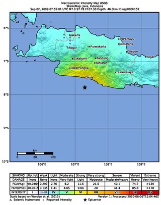
An earthquake occurred on September 2, 2009, at 14:55:01 local time in West Java, Indonesia. The magnitude 7.0 earthquake killed at least 81 people, injured over 1,297, and displaced over 210,000. The quake was felt in the capital Jakarta, although damage there was minimal, and it was Indonesia's deadliest earthquake since the 2006 Pangandaran earthquake and tsunami.
A 6.2 magnitude earthquake occurred in Afghanistan on October 22, 2009 at 19:51:27 UTC. The maximum Mercalli intensity was V (Moderate) at Fayzabad, Badakhshan.
On 7 September 2012, a series of earthquakes occurred in Yiliang County, Zhaotong, Yunnan. The two main shocks occurred at 11:19 and 12:16 China Standard Time. The earthquakes left 81 people dead and 821 injured. According to the officials, at least 100,000 people were evacuated and more than 20,000 houses were damaged.

The October 2015 Hindu Kush earthquake was a magnitude 7.5 earthquake that struck South Asia on 26 October 2015, at 13:39 AFT with the epicenter 45 km north of Kuran wa Munjan, Afghanistan, at a depth of 231.0 km.
The December 2015 Hindu Kush earthquake occurred with a moment magnitude of 6.3 in South Asia on 25 December 2015. One woman was killed in Pakistan. At least 100 people were injured in Pakistan and Afghanistan. The quake was also strongly felt in Tajikistan and India. The epicenter of the earthquake was in the Afghanistan-Tajikistan border region at a depth of 203.4 km.
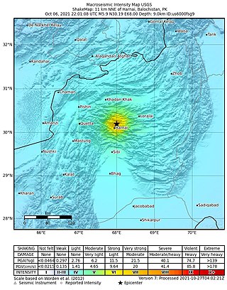
An earthquake struck Pakistan's province of Balochistan near the city of Harnai on 7 October 2021. The moment magnitude 5.9 Mww quake struck in the early morning at 03:01 local time, killing at least 42 people and injuring 300 others. The earthquake occurred just one day before the anniversary of the 2005 Kashmir earthquake.
The 1983 Hindu Kush earthquake occurred south of Fayzabad, Badakhshan in northeast Afghanistan at 03:52 PST on December 31, 1983, near the border with Pakistan and the USSR. Striking 214.5 km beneath the Hindu Kush mountains, the moment magnitude 7.4 quake affected three countries, killing at least 26 people and injuring several hundred.

The Lenin Peak disaster occurred on 13 July 1990 when 43 climbers were killed during an avalanche on the 7,134-meter-high mountain peak in northeast Tajikistan and Kyrgyzstan. The deadly avalanche was triggered by a moment magnitude scale 6.4 earthquake which struck at a depth of 216.8 km beneath the Hindu Kush mountains in neighbouring Afghanistan. The incident is believed to be the deadliest mountaineering disaster in history.
The 1991 Hindu Kush earthquake severely affected Afghanistan, Pakistan and the USSR on 1 February. It was an intermediate-depth earthquake with a hypocenter 143.2 km (89.0 mi) beneath the Hindu Kush mountains in Afghanistan. The shock measured 6.8 on the moment magnitude scale and had a maximum Mercalli intensity of X (Extreme). The reverse-faulting earthquake occurred in a seismically active region associated with faulting within a deforming oceanic plate at depth.

A 4.0-kilometre (2.5 mi) deep earthquake measuring magnitude (Mw ) 6.2 struck southeastern Afghanistan on 22 June 2022 at 01:24:36 AFT. The earthquake had a maximum Modified Mercalli intensity of IX (Violent). There were 1,052–1,163 deaths and 1,627–2,976 injured in Afghanistan and Pakistan. The worst affected provinces in Afghanistan were Paktika, Paktia, Khost and Nangarhar. Casualties and damage also occurred in Pakistan's Khyber Pakhtunkhwa. At least 10,000 homes collapsed or were severely damaged. The earthquake's shallow hypocenter, proximity to populated areas and low building quality contributed to its destructive effects. Shaking was felt over 500 km (310 mi) away by at least 119 million people, including Pakistan's Punjab and parts of India and Iran.
On September 5, 2022, a reverse faulting earthquake with a moderate magnitude of 5.1 struck Kunar Province, Afghanistan, close to the city of Jalalabad.

