December 2015 Hindu Kush earthquake

Last updated

December 2015 Hindu Kush earthquake
Afghanistan physical map.svg
Bullseye1.png
UTC  time2015-12-25 19:14:47
ISC  event 612128431
USGS-ANSS ComCat
Local date25 December 2015 (2015-12-25)
Local time23:44:47
Magnitude6.3 Mw
Depth203.4 km (126.4 mi)
Epicenter 36°29′10″N71°08′17″E / 36.486°N 71.138°E / 36.486; 71.138 [1]
Areas affected
Max. intensity MMI V (Moderate)
Casualties4 [2]

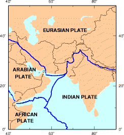
The December 2015 Hindu Kush earthquake occurred with a moment magnitude of 6.3 [1] [3] in South Asia on 25 December 2015. [4] One woman was killed in Pakistan. At least 100 people were injured in Pakistan and Afghanistan. [5] The quake was also strongly felt in Tajikistan and India. The epicenter of the earthquake was in the Afghanistan-Tajikistan border region at a depth of 203.4 km. [6]

Contents

Background

Map depicting regional tectonic plates Earthquake Information for Pakistan.png
Map depicting regional tectonic plates
RegionNumber of
deaths [2]
Number of
injuries
Flag of Pakistan.svg Khyber Pakhtunkhwa 383
Flag of Pakistan.svg Gilgit-Baltistan 15
Flag of Afghanistan (2013-2021).svg Nangarhar Province 12
Total4100

An earthquake of 7.3 Mw was felt in the same region [7] in October 2015 causing 398 deaths and 2,536 injuries in Pakistan [8] and Afghanistan. [9]

The Himalayan mountains are pushed up by the collision of tectonic plates, making them prone to devastating quakes. An earthquake in April 2015, Nepal's worst in 80 years, killed over 8,600 people. [10]

The last major earthquake in the same region of similar magnitude (7.6 Mw ) was almost ten years prior in October 2005, which resulted in 87,351 deaths, 75,266 injured, 2.8 million people being displaced, and 250,000 farm animals deaths. The notable difference between this earthquake and the 2005 earthquake is the depth of the seismic activity. The 2005 earthquake was 15 km deep while this earthquake was 203.4 km deep, reducing its effects at the surface. [11]

In recent studies, geologists claim that global warming is one of the reasons for increased seismic activity. According to these studies melting glaciers and rising sea levels disturb the balance of pressure on Earth's tectonic plates thus causing an increase in the frequency and intensity of earthquakes. This could be one of the reasons why the Himalayas are getting more prone to earthquakes in recent years. [12] [ better source needed ]

See also

Related Research Articles

<span class="mw-page-title-main">2005 Kashmir earthquake</span> Earthquake in South Asia

An earthquake occurred at 08:50:39 Pakistan Standard Time on 8 October 2005 in Azad Jammu and Kashmir, a territory under Pakistan. It was centred near the city of Muzaffarabad, and also affected nearby Balakot in Khyber Pakhtunkhwa and some areas of Jammu and Kashmir, India. It registered a moment magnitude of 7.6 and had a maximum Mercalli intensity of XI (Extreme). The earthquake was also felt in Afghanistan, Tajikistan, India and the Xinjiang region. The severity of the damage caused by the earthquake is attributed to severe upthrust. Over 86,000 people died, a similar number were injured, and millions were displaced. It is considered the deadliest earthquake in South Asia, surpassing the 1935 Quetta earthquake.

<span class="mw-page-title-main">2002 Hindu Kush earthquakes</span> Earthquakes in northern Afghanistan

The 2002 Hindu Kush earthquakes struck in northern Afghanistan during the month of March. At least 166 people were killed with a very large and intermediate-depth mainshock on March 3. Three weeks later, at least 1,200 were killed during a moderate but shallow event that had a maximum Mercalli intensity of VII. The M7.4 and M6.1 reverse events were focused in the Hindu Kush mountain range area.

<span class="mw-page-title-main">2008 Ziarat earthquakes</span> Earthquake in Balochistan, Pakistan

The 2008 Ziarat earthquakes hit the Pakistani province of Balochistan on October 29 with a moment magnitude of 6.4. The US Geological Survey reported that the first earthquake occurred 60 km (37 mi) north of Quetta and 185 km (115 mi) southeast of the Afghanistan city of Kandahar at 04:09 local time at a depth of 15 km (9.3 mi), at 30.653°N, 67.323°E. It was followed by another shallower magnitude 6.4 earthquake at a depth of 14 km (8.7 mi) approximately 12 hours after the initial shock, at 30.546°N, 67.447°E. 215 people were confirmed dead. More than 200 were injured, and 120,000 were rendered homeless. Qamar Zaman Chaudhry, director general of Pakistan Meteorological Department, stated the quake epicenter was 70 miles (110 km) north of Quetta, and about 600 km (370 mi) southwest of Islamabad.

A 6.2 magnitude earthquake occurred in Afghanistan on October 22, 2009 at 19:51:27 UTC. The maximum Mercalli intensity was V (Moderate) at Fayzabad, Badakhshan.

<span class="mw-page-title-main">2011 Dalbandin earthquake</span> Earthquake in Pakistan

The 2011 Dalbandin earthquake occurred on 19 January at 01:23 a.m. local time with a moment magnitude of Mw 7.2 and a maximum Mercalli intensity of VII. The shock occurred in a sparsely populated area of Balochistan, caused moderate damage, three deaths, and some injuries.

The 2013 Saravan earthquake occurred with a moment magnitude of 7.7 at 15:14 pm IRDT (UTC+4:30) on 16 April. The shock struck a mountainous area between the cities of Saravan and Khash in Sistan and Baluchestan Province, Iran, close to the border with Pakistan, with a duration of about 25 seconds. The earthquake occurred at an intermediate depth in the Arabian plate lithosphere, near the boundary between the subducting Arabian Plate and the overriding Eurasian Plate at a depth of about 80 km.

The 2013 Balochistan earthquakes took place in late September in southwestern Pakistan. The mainshock had a moment magnitude of 7.7 and a maximum Mercalli intensity of IX (Violent). At least 825 people were killed and hundreds more were injured. On 28 September, a M6.8 aftershock occurred to the north at a depth of 14.8 kilometres, killing at least 22 people.

<span class="mw-page-title-main">2014 Ludian earthquake</span> 6.1 magnitude earthquake in Yunnan, China

The 2014 Ludian earthquake struck Ludian County, Yunnan, China, with a moment magnitude of 6.1 on 3 August. The earthquake killed at least 617 people, injuring at least 2,400 others. As of 5 August 2014, 112 people remain missing. Over 12,000 houses collapsed and 30,000 were damaged. According to the United States Geological Survey, the earthquake occurred 29 km (18 mi) WSW of Zhaotong city at 16:30 local time (08:30 UTC).

<span class="mw-page-title-main">May 2015 Nepal earthquake</span> 7.3 magnitude earthquake near Kodari, Nepal

A major earthquake occurred in Nepal on 12 May 2015 at 12:50 pm local time with a moment magnitude of 7.3, 18 kilometres (11 mi) southeast of Kodari. The epicenter was on the border of Dolakha and Sindhupalchowk, two districts of Nepal. This earthquake occurred on the same fault as the larger magnitude 7.8 earthquake of 25 April, but further east than the original quake. As such, it is considered to be an aftershock of the April quake. It struck at a depth of 18.5 km (11.5 mi). Shaking was felt in northern parts of India including Bihar, Uttar Pradesh and West Bengal. Tremors were felt as far as about 2,400 km away from the epicenter in Chennai.

<span class="mw-page-title-main">October 2015 Hindu Kush earthquake</span> Earthquake in Pakistan, Afghanistan and India

The October 2015 Hindu Kush earthquake was a magnitude 7.5 earthquake that struck South Asia on 26 October 2015, at 13:39 AFT with the epicenter 45 km north of Kuran wa Munjan, Afghanistan, at a depth of 231.0 km.

On December 7, 2015, an earthquake measuring 7.2 on the moment magnitude scale struck Tajikistan 105 km (65 mi) west of Murghab at 07:50 UTC at a depth of 26.0 km (16.2 mi). The earthquake was also felt in neighboring Xinjiang in China, India, Afghanistan, Pakistan and Kyrgyzstan.

<span class="mw-page-title-main">2019 Kashmir earthquake</span> Earthquake in Kashmir

The 2019 Kashmir earthquake struck regions of Pakistan with an epicentre in Azad Kashmir on 24 September at 16:02 local time. It had a magnitude of 5.4 Mww and a maximum felt intensity of VII on the Modified Mercalli intensity scale or VIII on the European macroseismic scale. There was severe damage in Mirpur District, causing the deaths of 40 people and injuring a further 850. The epicentre of the shallow quake was near the city of Mirpur, Pakistan. The tremors were felt in the Kashmir region, Punjab (Pakistan), Punjab (India), Uttarakhand and northern parts of India including New Delhi.

The 2021 Assam earthquake struck 11 km away from Dhekiajuli, Assam, India at 07:51 (IST) on April 28, 2021 with a moment magnitude of 6.0 at 34.0 km (21.1 mi) depth. The quake struck with an epicenter 140 km north of the main city of Guwahati. It resulted in two fatalities and at least 12 injuries.

The 1983 Hindu Kush earthquake occurred south of Fayzabad, Badakhshan in northeast Afghanistan at 03:52 PST on December 31, 1983, near the border with Pakistan and the USSR. Striking 214.5 km beneath the Hindu Kush mountains, the moment magnitude 7.4 quake affected three countries, killing at least 26 people and injuring several hundred.

<span class="mw-page-title-main">Lenin Peak disaster</span> 1990 earthquake and subsequent avalanche in Tajikistan

The Lenin Peak disaster occurred on 13 July 1990 when 43 climbers were killed during an avalanche on the 7,134-meter-high mountain peak in northeast Tajikistan and Kyrgyzstan. The deadly avalanche was triggered by a moment magnitude scale 6.4 earthquake which struck at a depth of 216.8 km beneath the Hindu Kush mountains in neighbouring Afghanistan. The incident is believed to be the deadliest mountaineering disaster in history.

The 1991 Hindu Kush earthquake occurred northeast of Kabul, Afghanistan on February 1, 1991. It was an intermediate-depth earthquake with a hypocenter 142.4 km beneath the Hindu Kush mountains. It measured 6.9 on the moment magnitude scale, and affected neighbouring Pakistan and the USSR. At least 848 people were killed in both countries and damage was estimated at $26 million USD.

On 21 March 2023, a magnitude 6.5 earthquake struck Badakhshan Province, Afghanistan, with an intermediate depth of approximately 187 km (116 mi). The epicenter of the earthquake was 40 km (25 mi) south-southeast of Jurm.

References

  1. 1 2 ANSS. "Afghanistan 2015: M 6.3 - 42km WSW of Ashkasham, Afghanistan". Comprehensive Catalog. U.S. Geological Survey.
  2. 1 2 "Earthquake leaves 4 dead, more than 100 injured in Afghanistan and Pakistan". Fox News. 26 December 2015.
  3. "Strong 6.2 magnitude earthquake jolts parts of Pakistan, Afghanistan". The Express Tribune. 26 December 2015.
  4. "Quake rattles areas in Punjab, KPK, Azad Kashmir". Samaa TV.
  5. "Dozens injured in Afghan quake". The Australian. 26 December 2015. Retrieved 26 December 2015.
  6. "6.2-Magnitude Earthquake Hits Northern Afghanistan and Pakistan". NBC News. Associated Press. 26 December 2015.
  7. "M7.5 – 45km N of 'Alaqahdari-ye Kiran wa Munjan, Afghanistan". United States Geological Survey. 26 December 2015.
  8. "Live Updates". ndma.gov.pk. 5 November 2015. Archived from the original on 21 November 2015. Retrieved 26 December 2015.
  9. "The Latest: UN Mobilizing to Aid Quake Victims". The Associated Press . ABC News. 26 October 2015. Retrieved 26 December 2015.
  10. Press Trust of India (23 May 2015). "Nepal earthquake death toll reaches 8,635, over 300 missing". The Indian Express. Retrieved 26 December 2015.
  11. "Afghanistan Struck by Powerful Earthquake". The New York Times. 26 October 2015. Retrieved 26 December 2015.
  12. "Nepal earthquake could have been manmade disaster climate change brings". Newsweek . Retrieved 26 December 2015.