The 1974 Pattan earthquake occurred in the rugged and isolated Hunza, Hazara and Swat districts of northern Pakistan at 12:11 UTC on 28 December 1974. The 6.2 surface wave magnitude quake had a shallow focal depth of 22 km and was followed by numerous aftershocks. [2] An official estimate of the number killed was 5,300 with approximately 17,000 injured, and around 4,400 homes were destroyed. [3] A total of 97,000 were reported affected by the tremor. Most of the destruction was centered on the village of Pattan. The village was almost completely destroyed.
The epicentral region is characterized by steep-walled narrow canyons and valleys. Most of the population was concentrated along the rivers. Much of the destruction was caused by the numerous landslides and rockfalls which came tumbling down from high above. The main road leading into the area was blocked for about 25 miles (40 km) by landslides and rockfalls, hampering relief efforts. The government flew in emergency supplies by helicopter until the roads were reopened on 13 January.
The earthquake, which reached MMI V in Kabul, Afghanistan, affected some 1,000 square miles (2,600 km2) of the Indus Valley region. Several nations contributed money and supplies to aid the inhabitants of the stricken area. [4]
Earthquake prediction is a branch of the science of seismology concerned with the specification of the time, location, and magnitude of future earthquakes within stated limits, and particularly "the determination of parameters for the next strong earthquake to occur in a region". Earthquake prediction is sometimes distinguished from earthquake forecasting, which can be defined as the probabilistic assessment of general earthquake hazard, including the frequency and magnitude of damaging earthquakes in a given area over years or decades. Not all scientists distinguish "prediction" and "forecast", but the distinction is useful.
The 1993 Latur earthquake struck India at 3:56 am local time (UTC+05:30) on 30 September. The main area affected is the districts of Latur and Osmanabad, including the Ausa block of Latur and Omerga of Osmanabad in Maharashtra, Western India. Fifty-two villages were demolished in the intraplate earthquake. It measured 6.2 on the moment magnitude scale, and approximately 10,000 people died, whilst another 30,000 were injured. The earthquake's hypocenter was around 10 km deep – relatively shallow – allowing shock waves to cause more damage. It is considered the deadliest earthquake in the stable continental crust to have occurred in recorded history.

Pseudotachylyte is an extremely fine-grained to glassy, dark, cohesive rock occurring as veins that form through frictional melting and subsequent quenching during earthquakes, large-scale landslides, and impacts events. Chemical composition of pseudotachylyte generally reflects the local bulk chemistry, though may skew to slightly more mafic compositions due to the preferential incorporation of hydrous and ferro-magnesian minerals into the melt phase.

The 2008 Iceland earthquake was a doublet earthquake that struck on 29 May at 15:46 UTC in southwestern Iceland. The recorded magnitudes of the two main quakes were 5.9 and 5.8 Mw , respectively, giving a composite magnitude of 6.1 Mw . There were no human fatalities, but injuries were reported and a number of sheep were killed. The epicenter of the earthquake was between the towns of Hveragerði and Selfoss, about 45 kilometers (28 mi) east-southeast of the capital, Reykjavík. It was the strongest earthquake to hit Iceland since the summer of 2000.
The 1989 Malawi earthquake occurred on 10 March in central Malawi, with a moment magnitude of 6.3 and a maximum Mercalli intensity of VIII (Severe). It was preceded by a number of foreshocks, the largest being a 5.7 shock on the previous day. The earthquake was felt strongly throughout central Malawi, and also felt in parts of Mozambique and Zambia. Nine people were killed, with many others injured or left homeless.
The 1976 Friuli earthquake, also known in Italy as Terremoto del Friuli, occurred on 6 May 1976, at 21:00:13 with a moment magnitude of 6.5 and a maximum EMS intensity of X. The shock occurred in the Friuli region in northeast Italy near the town of Gemona del Friuli. 990 people were killed, up to about 3,000 were injured, and more than 157,000 were left homeless.
The 1991 Uttarkashi earthquake occurred at 02:53:16 Indian Standard Time (UTC+05:30) on 20 October with a moment magnitude of 6.8 and a maximum Mercalli intensity of IX (Violent). This thrust event was instrumentally recorded and occurred along the Main Central Thrust in the Uttarkashi and Gharwal regions of the Indian state of Uttarakhand. High intensity shaking resulted in the deaths of at least 768 people and the destruction of thousands of homes.
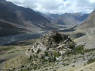
The 1975 Kinnaur earthquake occurred in the early afternoon of 19 January. It had a magnitude of 6.8 on the surface wave magnitude scale and a maximum perceived intensity of IX (Violent) on the Mercalli intensity scale, causing extensive damage in Himachal Pradesh, in northern India. Its epicentre was in Kinnaur district in the southeastern part of Himachal Pradesh and caused 47 casualties. Landslides, rock falls and avalanches caused major damage to the Hindustan-Tibet Road. The earthquake affected many monasteries and buildings in the state and led to an extensive restoration work in the late 1970s and early 1980s in Himachal Pradesh. The Spiti and Parachu valleys in particular suffered the greatest damage being on the north–south Kaurik-Chango fault, causing damage to landmarks such as Key Monastery and Tabo Monastery.
The 1975 Lice earthquake struck the Turkish district of Lice at 12:20 local time on 6 September. The epicenter of the 6.7 shock was located near the town of Lice and the maximum felt intensity was VIII (Severe) on the Mercalli intensity scale. More than 2,300 people were killed.

Tectonophysics, The International Journal of Geotectonics and the Geology and Physics of the Interior of the Earth is a weekly peer-reviewed scientific journal published by Elsevier. It was established in 1964 and covers the field of tectonophysics, including kinematics, structure, composition, and dynamics of the solid Earth at all scales.
The 1511 Idrija earthquake occurred on 26 March 1511 with a moment magnitude of 6.9 and a maximum EMS intensity of X. The epicenter was near the town of Idrija, although some place it in Friuli. The earthquake affected a large territory between Carinthia, Friuli, present-day Slovenia and Croatia. An estimated 3,000 people were killed and damage was considered severe. The earthquake was felt as far as in Switzerland and present-day Slovakia. A number of castles and churches were razed to the ground in a large area from northeast Italy to western Croatia.
The 1990 Gonghe earthquake occurred on April 26 at 17:37 China Standard Time in Hainan Tibetan Autonomous Prefecture, Qinghai Province. The mainshock had a surface wave magnitude of 7.0 Ms and a moment magnitude of 6.5 Mw . It was presaged by two foreshocks that struck merely seconds before the main earthquake. On the Mercalli intensity scale, the earthquake had a rating of IX (Violent).
The 1900 Venezuelan earthquake, occurred on October 28 at between 4:30 and 4:45 am local time. This earthquake had an epicenter off Miranda State or near the Venezuelan capital Caracas, in the Cariaco Basin. It had an estimated moment magnitude of 7.6–7.7 and a surface-wave magnitude of 7.7–8.4. It had a maximum Mercalli intensity assigned VIII–X, causing landslides and liquefaction events. Many buildings were severely damaged or collapsed during the earthquake. It is thought to be the last great earthquake of the 19th century and the largest instrumentally recorded in the republic, having been felt throughout.
The second shock in the 1962 Irpinia earthquake sequence was the largest and most destructive in a series of earthquakes in the southern Apennines. It occurred on 21 August at 18:19 CET, measuring 6.15 and assigned a maximum intensity of IX (Violent). It was preceded by an Mw 5.68 foreshock, and followed by a 5.34 aftershock. The earthquakes resulted in nearly 20 fatalities and significant property losses.
The 1997 Bojnurd earthquake occurred on 4 February at 14:07 IRST in Iran. The epicenter of the 6.5 earthquake was in the Kopet Dag mountains of North Khorasan, near the Iran–Turkmenistan border, about 579 km (360 mi) northeast of Tehran. The earthquake is characterized by shallow strike-slip faulting in a zone of active faults. Seismic activity is present as the Kopet Dag is actively accommodating tectonics through faulting. The earthquake left 88 dead, 1,948 injured, and affected 173 villages, including four which were destroyed. Damage also occurred in Shirvan and Bojnord counties. The total cost of damage was estimated to be over US$ 30 million.
The 1981 Darel Valley earthquake resulted in 220 fatalities and 3,000 injured. It occurred on September 12 at 12:15 PST, affecting the mountainous region of northern Pakistan. The earthquake measured 6.1 Mw at a depth of 13.0 km (8.1 mi).
In 1990, present day South Sudan was rocked by a series of violent earthquakes. It started with the largest event (Mw 7.2), and continued with multiple very large aftershocks for the next couple of months. The earthquake sequence ruptured over a length of 50 km (31 mi). It contains some of the largest recorded earthquakes anywhere in Africa.
The 1977 Khurgu earthquake struck southern Iran near Bandar Abbas in Hormozgan province on the morning of March 22. The earthquake measuring moment magnitude (Mw ) 6.7 struck at a depth of 12.5 km (7.8 mi). Thirty five villages were heavily damaged including over 20 which were destroyed. There were 152–167 people killed and 556 injured.
An earthquake struck Western Greece near the coastal city of Aigio at on 15 June 1995. The second destructive earthquake to strike Greece in a month, it measured 6.4–6.5 on the moment magnitude scale (Mw ). It was assigned a maximum Modified Mercalli intensity of VIII (Severe) and EMS-98 intensity of IX (Destructive). The horizontal peak ground acceleration reached 0.54 g and ground velocity peaked at 52 cm/s (20 in/s)—the strongest ground motion ever recorded in Greece. Fifteen minutes after the mainshock, a large aftershock struck, causing further damage to Aigio. Faulting occurred on either the Aigion fault or an unnamed offshore fault. Other faults in the region have the potential to produce earthquakes up to Mw 6.9, which poses a risk to Aigio and the surrounding Gulf of Corinth.
The 1968 Bartın earthquake occurred at 10:19:56 on September 3 with a moment magnitude of 6.3 and a maximum Mercalli Intensity of VIII (Severe). The thrust shock resulted in 24 to 29 deaths and 200 injuries. A tsunami was generated in the Black Sea with a maximum runup height of 3 metres (9.8 ft).
