2013 Balochistan earthquakes

Last updated

2013 Balochistan earthquakes
Pakistan Balochistan relief map.svg
Bullseye1.png
Pakistan relief location map.jpg
Bullseye1.png
UTC  time2013-09-24 11:29:47
ISC  event 608458290
USGS-ANSS ComCat
Local date24 September 2013
Local time16:29:48 PKT (UTC+5)
Magnitude7.7 Mw
Depth15.0 km (9.3 mi)
Epicenter 26°57′04″N65°30′04″E / 26.951°N 65.501°E / 26.951; 65.501
Type Oblique-slip
Areas affectedPakistan
Max. intensity MMI IX (Violent) [1]
Casualties825 dead, [2] [3] 700 injured [4] [5] [6]

The 2013 Balochistan earthquakes took place in late September in southwestern Pakistan. The mainshock had a moment magnitude of 7.7 and a maximum Mercalli intensity of IX (Violent). At least 825 people were killed and hundreds more were injured. On 28 September, a M6.8 aftershock occurred to the north at a depth of 14.8 kilometres (9.2 miles), killing at least 22 people. [7] [8]

Contents

Tectonic setting

On a broad scale, the tectonics of southern and central Pakistan reflect a complex plate boundary where the India plate slides northward relative to the Eurasia plate in the east, and the Arabia plate subducts northward beneath the Eurasia plate in the Makran (western Pakistan). These motions typically result in north–south to northeast–southwest strike-slip motion at the latitude of the 24 September earthquake that is primarily accommodated on the Chaman Fault, with the earthquake potentially occurring on one of the southernmost strands of this fault system. Further, more in-depth studies will be required to identify the precise fault associated with this event. Although seismically active, this portion of the Eurasia plate boundary region has not experienced large damaging earthquakes in recent history. In the past 40 years, only one significant event has occurred within 200 kilometres (120 mi) of this event, which was a Mw 6.1 earthquake in July 1990 that killed six people. [9]

Earthquake

USGS ShakeMap showing for the event M7.7 - 66km NNE of Awaran, Pakistan.jpg
USGS ShakeMap showing for the event

The United States Geological Survey reported that the earthquake took place on Tuesday 24 September 2013 at 11:29:48  UTC. The depth was reported to be 15 kilometres (9.3 mi). The earthquake reportedly lasted about a minute, causing panic in cities of southern Pakistan such as Karachi and Hyderabad. [10]

The earthquake occurred as a result of the oblique-strike-slip type motion at shallow crustal depths. The location and mechanism of the earthquake are consistent with rupture within the Eurasia plate above the Makran Trench subduction zone. The event occurred within the transition zone between northward subduction of the Arabian plate beneath the Eurasia plate and northward collision of the India plate with the Eurasia plate. [9] A 200 km (120 mi) surface rupture occurred as a result. Rupture initiated along a near-vertical fault and propagated mainly southwest along a curved fault that dipped 50° to the north. The fault segment is part of the Chaman Fault; during which its southern segment ruptured. Despite a mostly southwest rupture direction (with some rupture to the north), most of the aftershocks occurred north of the epicenter. Backprojection studies by Wang et al. suggest possible supershear rupture propagation velocity along some segments. [11]

The source fault, identified as the Hoshab Fault, was likely an old thrust fault due to its shallow dip angle. It formed within an accretionary wedge related to the Makran Trench. During the earthquake, displacements along the fault was exclusively strike-slip. A possible explanation for the faulting behavior is due to the accretionary wedge being pushed eastwards towards the Indian Plate. Much of the inferred displacements occurred no less than 10 km (6.2 mi) beneath the surface. Peak slip was estimated at 10 m (33 ft) while the average slip across the rupture was 6 m (20 ft). [12]

Impact

The earthquake killed at least 825 people and injured hundreds of others. [3] The earthquake struck a sparsely populated region of Pakistan. Most homes and buildings in the region are constructed of mud bricks and collapsed during the earthquake and aftershocks. An official in the Balochistan province claimed that 80 percent of the homes in the Awaran District had collapsed or were damaged. [13] In the regional capital Quetta, some areas appeared to be badly damaged. [14] [15] Officials from the Balochistan government estimated that at least 21,000 houses had been completely destroyed by the tremor, while some areas remained beyond the reach of rescue services 48 hours after the initial quake. [4]

PAGER impact estimates from the United States Geological Survey included a red alert level for initial shaking-related fatalities (35% chance of 1,000–10,000 fatalities, 27% chance of 10,000–100,000 fatalities) and an orange alert level for economic impact (35% chance of US$100 million–$1 billion, 26% chance of US$1–10 billion). [16]

The earthquake was felt in major cities across Pakistan, including Karachi, Hyderabad, Rawalpindi/Islamabad, Larkana, and Lahore. [10] The quake was also felt in Delhi, India, where some buildings shook, [17] and Muscat, Oman800 kilometres (500 mi) from the epicenter—where mild tremors shook tables and cabinets. [18] The earthquake shook in the parts of UAE, Iraq, Afghanistan, Iran and Qatar. [19] The earthquake also shook Saravan, Iran without causing any damage or casualties. [20] There were also minor tremors and aftershocks in the United Arab Emirates. [21]

Ground effects

Satellite images of Zalzala Jazeera off the coast of Gwadar Pakistan Earthquake Island.png
Satellite images of Zalzala Jazeera off the coast of Gwadar

The earthquake was apparently powerful enough to raise a small island, later dubbed Zalzala Jazeera, meaning "quake island", in the Arabian Sea, variously reported as being 350 metres (1,150 ft) to 1 kilometre (0.62 mi) off the shore of Gwadar. [15] [22] [23] The island is partially composed of rock, but mostly consists of mud and sand. The oval-shaped island was 60–70 feet (18–21 m) high and about 200–300 feet (61–91 m) long according to local people that visited the island the day after it appeared. They noticed a smell of gas and managed to ignite it, later extinguishing it with difficulty. [22]

The island is believed to be the result of a mud volcano. [24] In the region, deposits of frozen gas hydrates—which have a large methane content—exist beneath 300 to 800 metres (980–2,620 ft) of compressed sediment. [22] After such a large earthquake, the gas hydrates converted from frozen to gaseous form through the heat of friction and either raised the overlaying sediment enough to create fissures through which it escaped or rose through fissures resulting from the earthquake itself. Another possible contributing factor in the island's creation was the liquefaction of the seabed, which allowed finer, loosely packed sediments to become liquid-like and squeeze up through fissures in overlying compressed sediment. Locals who ventured to the island shortly after it formed heard a hissing noise at one end and started a fire which was difficult to extinguish. There are several mud volcanoes inland near Zalzala Jazeera and they are common in the vicinity of subducting plate boundaries; in fact, similar islands have appeared in the same region following earthquakes in 1945, 1999, 2001, and 2010. Because of its composition of softer sediments, the sea was predicted to erode the island completely within a few months. [22] By the end of 2016, the island had completely disappeared. [25]

Tsunami

Despite its inland epicentre, the earthquake generated a tsunami with a maximum height of 0.57 m (1.9 ft) in eastern Oman. [26]

Aftershocks

Aftermath

On 26 September, two days after the disaster, two rockets were fired at a helicopter carrying Maj. Gen. Muhammad Saeed Aleem, the National Disaster Management Authority chairman, as well as other officials and members of the media. Government sources blamed Balochi separatists, who are very active in the Awaran area. [4]

See also

Related Research Articles

<span class="mw-page-title-main">Earthquake</span> Sudden movement of the Earths crust

An earthquake – also called a quake, tremor, or temblor – is the shaking of the Earth's surface resulting from a sudden release of energy in the lithosphere that creates seismic waves. Earthquakes can range in intensity, from those so weak they cannot be felt, to those violent enough to propel objects and people into the air, damage critical infrastructure, and wreak destruction across entire cities. The seismic activity of an area is the frequency, type, and size of earthquakes experienced over a particular time. The seismicity at a particular location in the Earth is the average rate of seismic energy release per unit volume.

<span class="mw-page-title-main">September 2007 Sumatra earthquakes</span> Earthquakes affecting Indonesia

The September 2007 Sumatra earthquakes were a series of megathrust earthquakes that struck the Sunda Trench off the coast of Sumatra, Indonesia, with three of magnitude 7 or greater. A series of tsunami bulletins was issued for the area. The most powerful of the series had a magnitude of 8.4, which makes it in the top 20 of the largest earthquakes ever recorded on a seismograph.

<span class="mw-page-title-main">2008 Market Rasen earthquake</span> 2008 Earthquake epicentred around Market Rasen, Lincolnshire, England

On 27 February 2008 at 00:56:47.8s GMT an earthquake occurred at Market Rasen, Lincolnshire. According to the British Geological Survey the earthquake registered a reading of 5.2 on the Richter scale, with its epicentre 2.5 miles (4 km) north of Market Rasen and 15 miles (24 km) south-west of Grimsby.

<span class="mw-page-title-main">2000 Enggano earthquake</span> Earthquake affecting Indonesia

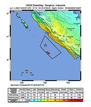
At 23:28 local time on June 4, 2000 southern Sumatra, Indonesia was struck by an earthquake of moment magnitude 7.9 with a maximum Mercalli intensity of VI (Strong). The event occurred off the coast near Enggano Island. There were more than 100 fatalities and up to 2,585 injuries. Over 730 aftershocks shook the area afterwards, one just eleven minutes after the mainshock.

<span class="mw-page-title-main">2008 Ziarat earthquakes</span> Earthquake in Balochistan, Pakistan

The 2008 Ziarat earthquakes hit the Pakistani province of Balochistan on October 29 with a moment magnitude of 6.4. The US Geological Survey reported that the first earthquake occurred 60 km (37 mi) north of Quetta and 185 km (115 mi) southeast of the Afghanistan city of Kandahar at 04:09 local time at a depth of 15 km (9.3 mi), at 30.653°N, 67.323°E. It was followed by another shallower magnitude 6.4 earthquake at a depth of 14 km (8.7 mi) approximately 12 hours after the initial shock, at 30.546°N, 67.447°E. 215 people were confirmed dead. More than 200 were injured, and 120,000 were rendered homeless. Qamar Zaman Chaudhry, director general of Pakistan Meteorological Department, stated the quake epicenter was 70 miles (110 km) north of Quetta, and about 600 km (370 mi) southwest of Islamabad.

A potent magnitude 6.6 Mw intraplate aftershock occurred at 17:16 JST (08:16 UTC) on 11 April, in the Hamadōri region of Fukushima, Japan. With a shallow focus of 13 km (8.1 mi), the earthquake was centred inland about 36 km (22 mi) west of Iwaki, causing widespread strong to locally severe shaking. It was one of many aftershocks to follow the 11 March Tōhoku earthquake, and the strongest to have its epicentre located inland.

<span class="mw-page-title-main">June 2011 Christchurch earthquake</span> June 2011 earthquake in New Zealand

The June 2011 Christchurch earthquake was a shallow magnitude 6.0 Mw earthquake that occurred on 13 June 2011 at 14:20 NZST. It was centred at a depth of 7 km (4.3 mi), about 5 km (3 mi) south-east of Christchurch, which had previously been devastated by a magnitude 6.2 MW earthquake in February 2011. The June quake was preceded by a magnitude 5.9 ML tremor that struck the region at a slightly deeper 8.9 km (5.5 mi). The United States Geological Survey reported a magnitude of 6.0 Mw and a depth of 9 km (5.6 mi).

The 2012 Indian Ocean earthquakes were magnitude 8.6 and 8.2 Mw  undersea earthquakes that struck near the Indonesian province of Aceh on 11 April at 15:38 local time. Initially, authorities feared that the initial earthquake would cause a tsunami and warnings were issued across the Indian Ocean; however, these warnings were subsequently cancelled. These were unusually strong intraplate earthquakes and the largest strike-slip earthquake ever recorded.

The 2012 Haida Gwaii earthquake occurred just after 8:04 p.m. PDT on October 27. The shock had a moment magnitude of 7.8 and a maximum Mercalli Intensity of V (Moderate). The earthquake's epicentre was on Moresby Island of the Haida Gwaii archipelago. This was the second largest Canadian earthquake ever recorded by a seismometer, after the 1949 Queen Charlotte Islands earthquake, about 135 kilometres (84 mi) away. One person died due to a car crash related to the tsunami in Oahu, Hawaii.

<span class="mw-page-title-main">2012 Shwebo earthquake</span> 6.8 magnitude earthquake in central Myanmar

The 2012 Shwebo earthquake occurred at 07:42 local time on 11 November in Myanmar. It had a magnitude of 6.8 on the moment magnitude scale and a maximum perceived intensity of VIII (Severe) on the Mercalli intensity scale. The epicenter was near the town of Male, 52 km NNE of the city of Shwebo, 64 km west of Mogok and 120 km north of Mandalay. Significant damage and possible casualties have been reported from near the epicenter, with up to 26 people dead and many more injured. Part of a bridge under construction fell into the Irrawaddy River near Shwebo and a gold mine collapsed at Sintku. An aftershock with a magnitude of 5.8 followed at 17:24 local time.

An earthquake occurred in the northern Aegean Sea between Greece and Turkey on May 24, 2014. It had a moment magnitude of 6.9 and a maximum Mercalli intensity of VIII (Severe). Serious damage was reported on the Turkish island of Imbros and the cities of Edirne and Çanakkale, as well as on the Greek island of Lemnos. The earthquake was felt in Bulgaria and southern Romania. Several aftershocks followed the main shock, the strongest measuring 5.3 ML. This aftershock struck the Gulf of Saros at 12:31 local time.

On July 6, 2017, a 6.5 magnitude earthquake hit Leyte, causing at least 4 deaths and 100 injuries. The quake also caused power interruptions in the whole of Eastern Visayas and nearby Bohol.

<span class="mw-page-title-main">2013 Craig, Alaska earthquake</span> Earthquake in Alaska and British Columbia

The 2013 Craig, Alaska earthquake struck on January 5, at 12:58 am (UTC–7) near the city of Craig and Hydaburg, on Prince of Wales Island. The Mw 7.5 earthquake came nearly three months after an Mw  7.8 quake struck Haida Gwaii on October 28, in 2012. The quake prompted a regional tsunami warning to British Columbia and Alaska, but it was later cancelled. Due to the remote location of the quake, there were no reports of casualties or damage.

The 1968 Borrego Mountain earthquake occurred on April 8, at 18:28 PST in the geologically active Salton Trough of Southern California. The Salton Trough represents a pull-apart basin formed by movements along major faults. This region is dominated by major strike-slip faults one of them being the San Jacinto Fault which produced the 1968 earthquake. The mainshock's epicenter was near the unincorporated community of Ocotillo Wells in San Diego County. The moment magnitude (Mw ) 6.6 strike-slip earthquake struck with a focal depth of 11.1 km (6.9 mi). The zone of surface rupture was assigned a maximum Modified Mercalli intensity (MMI) of VII.

<span class="mw-page-title-main">2021 Chignik earthquake</span> 7th largest earthquake in the US

An earthquake occurred off the coast of the Alaska Peninsula on July 28, 2021, at 10:15 p.m. local time. The large megathrust earthquake had a moment magnitude of 8.2 according to the United States Geological Survey (USGS). A tsunami warning was issued by the National Oceanic and Atmospheric Administration (NOAA) but later cancelled. The mainshock was followed by a number of aftershocks, including three that were of magnitude 5.9, 6.1 and 6.9 respectively.

The 2021 South Sandwich Islands earthquakes were a pair of powerful earthquakes, followed by many strong aftershocks which struck along the South Sandwich Trench in August 2021. The quakes measured 7.5 and 8.1 on the moment magnitude scale, according to the United States Geological Survey. The mainshock is tied with another event in 1929 as the largest earthquake ever recorded in the South Atlantic region, and is tied with the 2021 Kermadec Islands earthquake as the second largest earthquake of 2021.

The 2016 Alboran Sea earthquake struck offshore, north northeast of Al Hoceïma, Morocco in the Strait of Gibraltar on 25 January at 04:22:02 UTC, or roughly 05:22:02 West Africa Time. At its strongest in the Alboran Sea, the earthquake measured 6.3–6.4 on the moment magnitude scale (Mw ) at a shallow hypocenter depth of 12 km (7.5 mi). Assigned a maximum Modified Mercalli scale intensity of VI (Strong), the earthquake caused one fatality, injuries to at least 30 persons, and moderate damage in Morocco and Spain.

An earthquake struck approximately 53 kilometres SSE of the town of Mansfield, in the Victorian Alps of Australia on 22 September 2021, at 09:15 local time. The earthquake measured 5.9 on the moment magnitude scale. The earthquake caused minor structural damage in parts of Melbourne and left one person injured. The earthquake was also felt in New South Wales, Australian Capital Territory, South Australia and Tasmania. The earthquake was substantially stronger than the 1989 Newcastle earthquake that measured 5.6 and killed 13 people.

<span class="mw-page-title-main">2021 Balochistan earthquake</span> Earthquake near Harnai, Pakistan

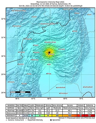
An earthquake struck Pakistan's province of Balochistan near the city of Harnai on 7 October 2021. The moment magnitude 5.9 Mww  quake struck in the early morning at 03:01 local time, killing at least 42 people and injuring 300 others. The earthquake occurred just one day before the anniversary of the 2005 Kashmir earthquake.

In November 2002, two medium-sized earthquakes struck northern Pakistan, causing major damage in Baltistan region and killing 41 people.

References

  1. "M 7.7 - 113 km NW of Bela, Pakistan". United States Geological Survey. 24 September 2013. Retrieved 11 August 2021.
  2. "825 dead, relief slow to reach Balochistan quake victims". Dunya News. 4 October 2013.
  3. 1 2 "Balochistan quake: toll jumps to 825". The Nation (Pakistan) . 1 October 2013. Archived from the original on 4 October 2013. Retrieved 4 October 2013.
  4. 1 2 3 "Pakistan quake death toll rises to 350". CNN. 26 September 2013. Retrieved 26 September 2013.
  5. "Pakistan: Death toll in the earthquake rises to 515". The Indian Express. 27 September 2013.
  6. "More than 100,000 left homeless after Pakistan earthquake". Al Jazeera. 27 September 2013.
  7. "M6.8 - 96 kilometres NNE of Awaran, Pakistan". United States Geological Survey. 28 September 2013.
  8. Agence France Presse (28 September 2013). "Powerful new Pakistan earthquake kills at least 22". Yahoo! News. Retrieved 1 October 2013.
  9. 1 2 PD-icon.svg This article incorporates public domain material from M7.7 - 63km NNE of Awaran, Pakistan. United States Geological Survey.
  10. 1 2 Menon, Meena (24 September 2013). "Quake in southern Pakistan kills 2, damages houses". The Hindu. Chennai, India. Retrieved 24 September 2013.
  11. Wang, Dun; Kawakatsu, Hitoshi; Mori, Jim; Ali, Babar; Ren, Zhikun; Shen, Xuelin (March 2016). "Backprojection analyses from four regional arrays for rupture over a curved dipping fault: The Mw 7.7 24 September 2013 Pakistan earthquake". Journal of Geophysical Research: Solid Earth. 121 (3): 1948–1961. Bibcode:2016JGRB..121.1948W. doi: 10.1002/2015JB012168 . S2CID   130332801.
  12. Avouac, Jean-Philippe; Ayoub, Francois; Wei, Shengji; Ampuero, Jean-Paul; Meng, Lingsen; Leprince, Sebastien; Jolivet, Romain; Duputel, Zacharie; Helmberger, Don (2014). "The 2013, Mw 7.7 Balochistan earthquake, energetic strike-slip reactivation of a thrust fault". Earth and Planetary Science Letters. 391: 128-134. doi:10.1016/j.epsl.2014.01.036.
  13. "At least 208 killed in Balochistan earthquake". Dawn. 25 September 2013. Retrieved 25 September 2013.
  14. Yusufzai, Gul (24 September 2013). "Quake kills 45 in Pakistan, creates new island in sea". Reuters. Retrieved 24 September 2013.
  15. 1 2 "Deadly earthquake strikes Pakistan's Balochistan". BBC News. 25 September 2013. Retrieved 24 September 2013.
  16. "M7.8 – 69km NNE of Awaran, Pakistan (BETA)". Earthquake Hazards Program. United States Geological Survey. Retrieved 24 September 2013.
  17. "Powerful earthquake strikes Pakistan's Balochistan". BBC News. 25 September 2013. Retrieved 24 September 2013.
  18. Vaidya, Sunil (24 September 2013). "Tremors from Pakistan quake felt in Muscat". gulfnews.com. Retrieved 24 September 2013.
  19. "New photos of Pakistan's 'Earthquake Island'". Fox News. Retrieved 24 September 2013.
  20. "Strong Quake in Pakistan Spares Southeast Iran". Tasnim News Agency. 25 September 2013.
  21. "Earthquake jolts Pakistan, tremors felt in". Gulf News . 28 September 2013.
  22. 1 2 3 4 Khan, Ilyas (27 September 2013). "Pakistan quake island off Gwadar 'emits flammable gas'". BBC News. Retrieved 26 September 2013.
  23. "Island discovered as a result of earthquake in Pakistan". IBNLive.in.com. Press Trust of India. Archived from the original on 9 October 2013. Retrieved 24 September 2013.
  24. "Satellites reveal new views of Pakistan's 'Earthquake Island'". NBC News . 1 October 2013. Retrieved 9 October 2013.
  25. "Gwadar's quake island disappears". DAWN.COM. 31 December 2016. Retrieved 31 December 2016.
  26. "Tsunami Event: BALOCHISTAN, PAKISTAN". NGDC.
  27. "M 5.8 - 89km NNE of Awaran, Pakistan". United States Geological Survey . Retrieved 24 September 2013.
  28. "M 5.6 - 102km NNE of Awaran, Pakistan". United States Geological Survey . Retrieved 24 September 2013.
  29. "M5.5 – 78km NNE of Awaran, Pakistan". United States Geological Survey . Retrieved 24 September 2013.
  30. "M6.8 - 85km NNE of Awaran, Pakistan". United States Geological Survey . Retrieved 28 September 2013.

Sources