1555 Kashmir earthquake

Last updated
1555 Kashmir earthquake
Pakistan relief location map.jpg
Green pog.svg
Kabul
Green pog.svg
Islamabad
Green pog.svg
Lahore
Bullseye1.png
Local dateSeptember 1555
Local timeMidnight
Magnitude7.6–8.0 Mw [1]
DepthShallow
Epicenter 33°30′N75°30′E / 33.5°N 75.5°E / 33.5; 75.5
Type Thrust
Areas affected India, Pakistan
Max. intensity XII (Extreme) [2]
LandslidesYes
ForeshocksSeveral months prior
AftershocksLasted several months
Casualties600–60,000 dead

The 1555 Kashmir earthquake occurred at around midnight in the month of Ashvin in the Hindu calendar, or September in the Gregorian calendar, although the exact day of occurrence is not known. The earthquake seriously impacted the Kashmir Valley in present-day Pakistan and northwestern India. A moment magnitude (Mw) of 7.6 to 8.0 and Modified Mercalli intensity of XII (Extreme) has been estimated for the earthquake. [1] [3] Thought to be one of the most destructive in the Kashmir Valley, the earthquake caused serious widespread damage and ground effects, killing an estimated 600–60,000 individuals. [2] [4]

Contents

Tectonic setting

Northern Pakistan and India are situated at the corner of an active destructive plate boundary that separates the Indian Plate from the Eurasian Plate. The boundary is defined along the Main Himalayan Thrust where the Indian Plate is colliding with the Eurasian Plate. The slightly oblique convergence occurs at a rate of 17 ± 2 mm/yr along the Main Himalayan Thrust while the nearby Karakoram fault system accommodates right-lateral strike-slip movement at 5 ± 2 mm/yr. [5]

The high convergence rate means many of the plate boundary faults are accommodating strain while locked, frequently releasing them in moderate-sized earthquakes, and sometimes in very large events. The occurrence of large earthquakes makes the Kashmir region vulnerable to deadly earthquakes.

Earthquake

The earthquake is thought to have been associated with a rupture on an active thrust fault that forms part of the plate boundary of the Kashmir Himalayas. Until recently, the source fault and possible surface ruptures of the earthquake have yet to be identified due to the lack of information of the event, in addition to the paleoseismicity of the region is poorly studied. The Main Frontal Thrust, Medlicott-Wadia (Riasi) Thrust, as well as the Kashmir Basin Fault (then the Balapur Fault) has been proposed as the seismogenic structure responsible for the earthquake. [6]

The Medlicott-Wadia Thrust is expressed on the surface as two branching fault structures; the Scorpion and Rain faults. Paleoseismic studies have identified three large earthquakes on the Rain Fault, and two on the Scorpion Fault in the past 3,500 years. An account in Persian describing a destructive earthquake in 1250 BC corresponded to the oldest event which was dated at 1661 BC and 929 BC. The 1250 BC earthquake produced several meters of slip at the surface. Another earthquake occurred between 1118 BC and 929 BC with less than 1 meter of maximum slip. The Rain Fault may have ruptured in one or two earthquakes sometime between 1110 BC and 660 AD, and is possible that the two faults were involved in an earthquake in approximately 1000 BC. Persian and Sanskrit records also corresponded well with two earthquakes on the Rain Fault dated between 660 AD and 1470 AD. [6]

The most recent paleoearthquake rupture is dated at 1470 AD or later. Large colluvial wedges associated with the rupture suggest the event caused high intensity shaking at the surface. The date of the rupture might suggest it was associated with the 1555 AD earthquake. [6]

An earlier trenching survey conducted at the Chandigarh Fault near the Main Frontal Thrust also found a surface rupture that likely formed in 1426 to 1700 AD. This surface rupture could correspond to the 1555 AD earthquake which is had an estimated rupture length of 150 km. [7]

Future hazard

In the wake of the 2005 Kashmir earthquake, much attention has been given to the Kashmir region in understanding the earthquake tectonics and assessing the seismic risk. The 1555 earthquake rupture is located roughly between that of the 2005 and 1905 Kangra earthquakes. No major seismic events have occurred since the 1555 earthquake in the 250-km-long Kashmir seismic gap on the Main Himalayan plate boundary fault. With a slip rate of 16 mm/yr, the accumulated slip since 1555 is estimated at 7.4 meters. If the 1555 earthquake released all the elastic energy accumulated since the previous earthquake, and fresh accumulation of stress began after the 1555 event, the next large earthquake could be as large as 7.8 Mw. [8]

Historical description

The devastation of the 1555 earthquake was well documented in Persian and Sanskrit. The historical accounts described a series of earthquakes, the strongest occurring at midnight in the month Asvina of the year 30 in the Hindu calendar. It describes the Kashmir Valley rocked by strong tremors at night while many of the residents were asleep. Many dwellings collapsed onto their residents, killing them. Homes that were well-constructed with firm foundations were not spared from the destruction; collapsing as well. Large ground fissures and sinkholes appeared in the landscape, swallowing many homes. Survivors broke through their roofs to escape from their damaged homes. Some wood-constructed structures fell into the Jhelum River and floated downstream. Those who survived the collapses managed to escape from the debris. [9]

Many towns and villages were completely destroyed in Kashmir. In the communities of Jalu and Damper, the force of the earthquake sheared off the foundations of homes and roots of trees, and displaced them onto the opposite bank of the Jhelum River. The town of Madar, located at the base of a hill, was buried by a landslide, causing the deaths of 600 to 60,000 people. [9] The two villages Hassanpur and Hussainpur, located on the opposite side of the Veshaw River, was suddenly shifted to the other side during the earthquake. [10] The earthquake formed large cracks in the ground, stopped water from flowing from existing natural springs, while in other locations, water erupted from the ground. [9] Damage was reported up to 50 km southwest and 140 km southeast of Srinagar.

The Laxmi Narayana Temple in Chamba, Himachal Pradesh, India, also suffered some damage to its pillars. [11]

Months prior to the mainshock, there was a series of foreshocks. An aftershock sequence that lasted several days was also documented in the scripts. On some days, multiple aftershocks could be felt. [9] This categorizes the 1555 Kashmir earthquake sequence as a classic foreshock-mainshock-aftershock earthquake sequence.

The famous historical documentation of towns shifted across riverbanks during the 1555 event was likely a gradual process rather than sudden. Tilted tree stumps at the bank of the Jhelum River at the locations described suggest slumping due to ground failure along the riverbank. [12]

Restoration and repair works continued for two months after the earthquake. [9]

See also

Related Research Articles

<span class="mw-page-title-main">San Jacinto Fault Zone</span> Southern Californian fault zone

The San Jacinto Fault Zone (SJFZ) is a major strike-slip fault zone that runs through San Bernardino, Riverside, San Diego, and Imperial Counties in Southern California. The SJFZ is a component of the larger San Andreas transform system and is considered to be the most seismically active fault zone in the area. Together they relieve the majority of the stress between the Pacific and North American tectonic plates.

The 1991 Uttarkashi earthquake occurred at 02:53:16 Indian Standard Time (UTC+05:30) on 20 October with a moment magnitude of 6.8 and a maximum Mercalli intensity of IX (Violent). This thrust event was instrumentally recorded and occurred along the Main Central Thrust in the Uttarkashi and Gharwal regions of the Indian state of Uttarakhand. High intensity shaking resulted in the deaths of at least 768 people and the destruction of thousands of homes.

<span class="mw-page-title-main">Marlborough fault system</span> Active fault system in New Zealand

The Marlborough fault system is a set of four large dextral strike-slip faults and other related structures in the northern part of South Island, New Zealand, which transfer displacement between the mainly transform plate boundary of the Alpine fault and the mainly destructive boundary of the Kermadec Trench, and together form the boundary between the Australian and Pacific Plates.

The 1838 San Andreas earthquake is believed to be a rupture along the northern part of the San Andreas Fault in June 1838. It affected approximately 100 km of the fault, from the San Francisco Peninsula to the Santa Cruz Mountains. It was a strong earthquake, with an estimated moment magnitude of 6.8 to 7.2, making it one of the largest known earthquakes in California. The region was lightly populated at the time, although structural damage was reported in San Francisco, Oakland, and Monterey. It is unknown whether there were fatalities. Based on geological sampling, the fault created approximately 1.5 meters of slip.

<span class="mw-page-title-main">Sierra Madre Fault Zone</span> Seismic fault in Southern California

Situated at the boundary to the San Gabriel Valley and San Fernando Valley, the Sierra Madre Fault Zone runs along the southern edge of the San Gabriel Mountains for a total of 95 kilometers (59 mi), where the northwesternmost 19 km (12 mi) comprises the San Fernando Fault. A 1980s paleoseismic study that included a trench investigation and mapping revealed that a major earthquake had most likely not occurred to the east of the San Fernando rupture area for at least the last several thousand, and possibly the last 11,000 years.

<span class="mw-page-title-main">2019 Kashmir earthquake</span> Earthquake in Kashmir

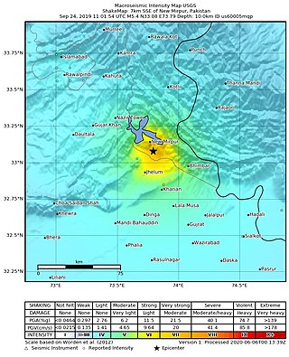
The 2019 Kashmir earthquake struck regions of Pakistan with an epicentre in Azad Kashmir on 24 September at 16:02 local time. It had a magnitude of 5.4 Mww and a maximum felt intensity of VII on the Modified Mercalli intensity scale or VIII on the European macroseismic scale. There was severe damage in Mirpur District, causing the deaths of 40 people and injuring a further 850. The epicentre of the shallow quake was near the city of Mirpur, Pakistan. The tremors were felt in the Kashmir region, Punjab (Pakistan), Punjab (India), Uttarakhand and northern parts of India including New Delhi.

<span class="mw-page-title-main">Main Himalayan Thrust</span> Geological feature

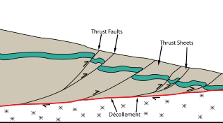
The Main Himalayan Thrust (MHT) is a décollement under the Himalaya Range. This thrust fault follows a NW-SE strike, reminiscent of an arc, and gently dips about 10 degrees towards the north, beneath the region. It is the largest active continental megathrust fault in the world.

The 1973 Luhuo earthquake struck near the town of Zhaggo in Garzê Tibetan Autonomous Prefecture of Sichuan Province, China on February 6, 1973, with a magnitude of 7.6 Ms. The earthquake had a maximum intensity of X (Extreme) on the Modified Mercalli intensity scale. It resulted in between 2,175 and 2,204 deaths and a further 2,743 injuries. Serious and widespread destruction occurred in Luhuo County.

The 2021 Assam earthquake struck 11 km away from Dhekiajuli, Assam, India at 07:51 (IST) on April 28, 2021 with a moment magnitude of 6.0 at 34.0 km (21.1 mi) depth. The quake struck with an epicenter 140 km north of the main city of Guwahati. It resulted in two fatalities and at least 12 injuries.

<span class="mw-page-title-main">2021 Chignik earthquake</span> 7th largest earthquake in the US

An earthquake occurred off the coast of the Alaska Peninsula on July 28, 2021, at 10:15 p.m. local time. The large megathrust earthquake had a moment magnitude of 8.2 according to the United States Geological Survey (USGS). A tsunami warning was issued by the National Oceanic and Atmospheric Administration (NOAA) but later cancelled. The mainshock was followed by a number of aftershocks, including three that were of magnitude 5.9, 6.1 and 6.9 respectively.

The 1889 Chilik earthquake occurred on July 11 on the Gregorian calendar, or June 30 on the Julian calendar at 15:14 local time in the Tien Shan mountains. The earthquake measured an estimated Mw  7.9–8.0 on the moment magnitude scale and was assigned a maximum intensity of X (Devastating) on the MSK 64 and Rossi-Forel scales. Over 92 people across Kazakhstan, Kyrgyzstan and China were killed.

The 1992 Kohat earthquake struck Khyber Pakhtunkhwa Province in Pakistan on May 20. The Mw  6.3 earthquake inflicted significant damage in the nearby city Kohat. An estimated 36 people died and 100 were injured in the Peshawar and Kohat districts. Four-hundred (400) homes were wiped out, affecting 2,100 residents in the region.

The 1850 Xichang earthquake rocked Sichuan Province of Qing China on September 12. The earthquake which caused major damage in Xichang county had an estimated moment magnitude of 7.6–7.9 Mw  and a surface wave magnitude of 7.5–7.7 Ms . An estimated 20,650 people died.

The 1885 Kashmir earthquake, also known as the Baramulla earthquake occurred on 30 May in Srinagar. It had an estimated moment magnitude of Mw  6.3–6.8 and maximum Medvedev–Sponheuer–Karnik scale intensity of VIII (Damaging). At least 3,081 people died and severe damage resulted.

The 1803 Garhwal earthquake occurred in the early morning of September 1 at 01:30 local time. The estimated 7.8-magnitude-earthquake had an epicenter in the Garhwal Himalaya near Uttarkashi, British India. Major damage occurred in the Himalaya and Indo-Gangetic Plain, with the loss of between 200 and 300 lives. It is among the largest Himalaya earthquakes of the 19th-century, caused by thrust faulting.

Bhutan was struck by a major earthquake on 4 May 1714. It had an estimated magnitude of about 8.1 Mw and caused shaking that reached IX (Violent) on the Modified Mercalli intensity scale. It is thought to have been caused by rupture of the Bhutan part of the Main Frontal Thrust. Damage was reported from west central Bhutan and northeast India. The earthquake resulted in "many fatalities".

<span class="mw-page-title-main">1988 Tennant Creek earthquakes</span> Sequence of strong quakes in Northern Territory

On 22 January 1988, a sequence of destructive earthquakes measuring 6.2, 6.3, and 6.6 struck southwest of Tennant Creek, Australia which was felt as far north as Darwin and in other regions of the country. The largest event of the sequence was the largest earthquake ever recorded in mainland Australia since records began in 1800. An intensity of IX (Violent) was observed. Despite the large magnitude of the earthquakes and a close proximity to a town, in a country where earthquakes of this size are not common, damages were limited. Thousands of aftershocks were reported and felt across Northern Territory.

The Keichō–Fushimi earthquake struck Japan on September 5, 1596. The earthquake measuring 7.5 ± 0.25 MJMA produced intense shaking across the Kansai region. Devastation was recorded in Kyoto and over 1,200 people perished.

The 1755 Meknes earthquake affected Morocco on 27 November 1755. The earthquake had a moment magnitude (Mw ) estimated at between 6.5 and 7.0. It devastated the cities of Fes and Meknes—killing at least 15,000 people in both cities.

References

  1. 1 2 Jouanne François; Naveed Munawar; Jean-Louis Mugnier; Awais Ahmed; Adnan Awan; Pascale Bascou; Riccardo Vassallo (12 August 2020). "Seismic Coupling Quantified on Inferred Décollements Beneath the Western Syntaxis of the Himalaya" (PDF). Tectonics. 39 (9). Bibcode:2020Tecto..3906122J. doi:10.1029/2020TC006122. S2CID   225459564.
  2. 1 2 "Significant Earthquake Information INDIA: KASHMIR: SRINAGAR". ngdc.noaa.gov. NCEI. Retrieved 7 August 2021.
  3. Basab Mukhopadhyay; Sujit Dasgupta (2015). "Seismic hazard assessment of Kashmir and Kangra valley region, Western Himalaya, India". Geomatics, Natural Hazards and Risk. 6 (2): 149–183. Bibcode:2015GNHR....6..149M. doi:10.1080/19475705.2013.832405. S2CID   129291097.
  4. Maqbool Yousuf; Syed Kaiser Bukhari; Ghulam Rasool Bhat; Aamir Ali (2020). "Understanding and managing earthquake hazard visa viz disaster mitigation strategies in Kashmir valley, NW Himalaya". Progress in Disaster Science. 5: 100064. Bibcode:2020PrDS....500064Y. doi: 10.1016/j.pdisas.2020.100064 .
  5. Bhaskar Kundu; Rajeev Kumar Yadav; Bikram Singh Bali; Sonalika Chowdhury; V. K. Gahalaut (2014). "Oblique convergence and slip partitioning in the NW Himalaya: Implications from GPS measurements". Tectonics. 33 (10): 2013–2024. Bibcode:2014Tecto..33.2013K. doi: 10.1002/2014TC003633 .
  6. 1 2 3 Riccardo Vassallo; Jean-Louis Mugnier; Hervé Jomard; Joaquin Cortès Aranda; Manzoor A. Malik; François Jouanne; Jean-François Buoncristiani (2020). "Recurrence of large paleo-earthquakes in Kashmir Himalaya seismic gap (Riasi area, India)". Journal of Asian Earth Sciences. 201: 104505. Bibcode:2020JAESc.20104505V. doi: 10.1016/j.jseaes.2020.104505 .
  7. Shreya Arora; Javed N. Malik (2017). "Overestimation of the earthquake hazard along the Himalaya: constraints in bracketing of medieval earthquakes from paleoseismic studies". Geoscience Letters. 4 (19): 19. Bibcode:2017GSL.....4...19A. doi: 10.1186/s40562-017-0083-6 .
  8. Sridevi Jade; Ramees R. Mir; Chiranjeevi G Vivek; T. S. Shrungeshwa; I. A. Parvez; Rakesh Chandra; D. Suri Babu; S. Vishal Gupta; Ankit; Siva Sai Kumar Rajana; V. K. Gaur (2020). "Crustal deformation rates in Kashmir valley and adjoining regions from continuous GPS measurements from 2008 to 2019". Scientific Reports. 10 (17927): 17927. Bibcode:2020NatSR..1017927J. doi:10.1038/s41598-020-74776-5. PMC   7577991 . PMID   33087736.
  9. 1 2 3 4 5 R.N. Iyengar; D. Sharma; J.M. Siddiqui (1999). "Earthquake history of India in medieval times" (PDF). Indian Journal of History of Science. 34 (3): 181–237.
  10. Bashir Ahmad Bilal (2015). "Kashmir Earthquake of 1555 and 1885". Greater Kashmir. GK Magazine. Retrieved 7 August 2021.
  11. Nicholas St. Fleur (27 July 2016). "Earthquake Clues From Ancient Temples in the Himalayas". The New York Times . Retrieved 7 August 2021.
  12. Susan Hough; Roger Bilham; Ismail Bhat (2009). "Kashmir Valley mega earthquakes: Estimates of the magnitudes of past seismic events foretell a very shaky future for this pastoral valley". American Scientist. 97 (1).