 | |
| UTC time | 2011-09-18 12:40:51 |
|---|---|
| ISC event | 17238846 |
| USGS-ANSS | ComCat |
| Local date | 18 September 2011 |
| Local time | 18:10 IST 18:25 NPT 18:40 BTT 20:40 CST |
| Duration | 30–40 seconds |
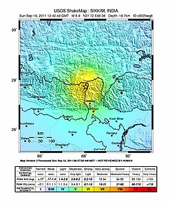
| Magnitude | 6.9 Mw |
| Depth | 19.7 km (12.1 mi) |
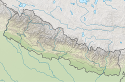
| Epicenter | Taplejung, Nepal 27°43′23″N88°03′50″E / 27.723°N 88.064°E |
| Type | Intraplate [1] |
| Areas affected | India Bangladesh Nepal Bhutan China |
| Total damage | $22.3 billion USD [2] |
| Max. intensity | MMI VII (Very strong) [3] |
| Landslides | Yes |
| Aftershocks | Yes |
| Casualties | At least 111 killed |
The 2011 Sikkim earthquake (also known as the 2011 Himalayan earthquake) occurred with a moment magnitude of 6.9 and was centered within the Kanchenjunga Conservation Area, near the border of Nepal and the Indian state of Sikkim, at 18:10 IST on Sunday, 18 September. [4] The earthquake was felt across northeastern India, Nepal, Bhutan, Bangladesh and southern Tibet.
Contents
- Earthquake
- Intensity
- Aftershocks
- Impact
- India
- Nepal
- Bangladesh
- China
- Bhutan
- Rescue operations and compensation
- India 2
- China 2
- See also
- References
- External links
At least 111 people were killed in the earthquake. [5] Most of the deaths occurred in Sikkim, with reports of fatalities in and near Singtam in the East Sikkim district. [6] Several buildings collapsed in Gangtok. [7] Eleven are reported dead in Nepal, including three killed when a wall collapsed in the British Embassy in Kathmandu. [8] Elsewhere, structural damage occurred in Bangladesh, Bhutan, and across Tibet; another seven fatalities were confirmed in the latter region.
The quake came just a few days after an earthquake of 4.2 magnitude hit Haryana's Sonipat district, sending tremors in New Delhi. [9] The earthquake was the fourth significant earthquake in India of September 2011. [10]
Exactly a year after the original earthquake at 5:55 pm on 18 September 2012, another earthquake of magnitude 4.1 struck Sikkim, sparking panic among the people observing the anniversary of the original quake. [1] [11] [12] [13]