An earthquake light also known as earthquake lightning or earthquake flash is a luminous optical phenomenon that appears in the sky at or near areas of tectonic stress, seismic activity, or volcanic eruptions. There is no broad consensus as to the causes of the phenomenon involved. The phenomenon differs from disruptions to electrical grids – such as arcing power lines – which can produce bright flashes as a result of ground shaking or hazardous weather conditions.
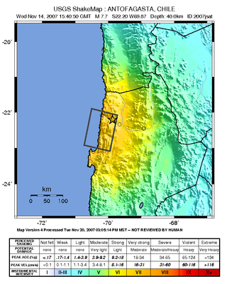
The 2007 Tocopilla earthquake occurred on November 14 at . Its epicenter was located between Quillagua and Tocopilla, affecting the Tarapacá and the Antofagasta regions in northern Chile. The earthquake had a moment magnitude of 7.7 and lasted about 3 minutes and 35 seconds. Seventeen aftershocks of magnitude greater than 5.3, including one of magnitude 7.1 and two others of magnitude 6.3 or higher, were recorded. The Pacific Tsunami Warning Center issued a tsunami warning, stating a tsunami had been generated; after one hour, this warning was cancelled. The earthquake was felt from Santiago, 1,245 km south from the epicenter, to La Paz, about 700 km north-northeast.

The 2010 Chile earthquake and tsunami occurred off the coast of central Chile on Saturday, 27 February at 03:34:12 local time, having a magnitude of 8.8 on the moment magnitude scale, with intense shaking lasting for about three minutes. It was felt strongly in six Chilean regions that together make up about 80 percent of the country's population. According to the United States Geological Survey (USGS) the cities experiencing the strongest shaking—VIII (Severe) on the Mercalli intensity scale (MM)—were Concepción, Arauco, and Coronel. According to Chile's Seismological Service, Concepción experienced the strongest shaking at MM IX (Violent). The earthquake was felt in the capital Santiago at MM VII or MM VIII. Tremors were felt in many Argentine cities, including Buenos Aires, Córdoba, Mendoza, and La Rioja. Tremors were felt as far north as the city of Ica in southern Peru. It is the largest earthquake to hit Chile since the 1960 Valdivia earthquake. A 2014 study contended that water pressure built up between the two plates had been the catalyst.

The 2010 Baja California earthquake occurred on April 4 with a moment magnitude of 7.2 and a maximum Mercalli intensity of VII. The shock originated at south of Guadalupe Victoria, Baja California, Mexico.
The 2010 Oaxaca earthquake struck Oaxaca, Mexico on June 30, 2010, with an magnitude of 6.3. Many people in different cities left their beds and ran into the street, as the quake struck at 2:22 am.
The 2011 Guerrero earthquake struck with a moment magnitude of 5.7 in southern Mexico at on 5 May. It was positioned west of Ometepec, Guerrero, with a focal depth of 24 km (14.9 mi), and was lightly felt in many adjacent areas.

The 2010 Pichilemu earthquakes, also known as the Libertador O'Higgins earthquakes, were a pair of intraplate earthquakes measuring 6.9 and 7.0 that struck Chile's O'Higgins Region on 11 March 2010 about 16 minutes apart. The earthquakes were centred 15 kilometres (9.3 mi) northwest of the city of Pichilemu.
The 2012 Guerrero–Oaxaca earthquake struck southern Mexico with a moment magnitude of 7.4 at on Tuesday, 20 March. Its epicenter was near Ometepec, in the border between the states of Guerrero and Oaxaca. With a shallow focus of 20 km, the earthquake caused strong shaking over a large area along the Oaxaca–Guerrero border and the adjacent Pacific coastline. Significant tremors were felt in areas up to several hundred kilometers away, including Mexico City and also in Guatemala. Two people were killed and over 30,000 houses were damaged or destroyed.
The 2012 Costa Rica earthquake occurred at 08:42 local time on September 5. The epicenter of the 7.6 Mw earthquake was in the Nicoya Peninsula, 11 kilometers east-southeast of Nicoya. A tsunami warning was issued shortly afterwards, but later cancelled. Two people are known to have died, one from a heart attack and another, a construction worker, crushed by a collapsing wall. It was the second strongest earthquake recorded in Costa Rica's history, following the 1991 Limon earthquake.
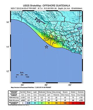
The 2012 Guatemala earthquake occurred on November 7 at . The shock had a moment magnitude of 7.4 and a maximum Mercalli Intensity of VII. The epicenter was located in the Pacific Ocean, 35 kilometres (22 mi) south of Champerico in the department of Retalhuleu. The affected region is earthquake-prone, where the Cocos plate is being subducted along the Middle America Trench beneath the North American and the Caribbean plates, near their triple junction.

The 2016 Sumatra earthquake was a 7.8 magnitude earthquake which struck on 2 March 2016 in the Indian Ocean, approximately 800 kilometers southwest of Sumatra in Indonesia. Tsunami warnings were issued for Indonesia and Australia, but were withdrawn two hours later. There were no deaths directly related to the earthquake.
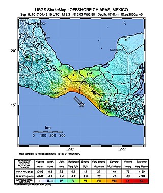
The 2017 Chiapas earthquake struck at 23:49 CDT on 7 September in the Gulf of Tehuantepec off the southern coast of Mexico near the state of Chiapas, approximately 87 kilometres (54 mi) southwest of Pijijiapan, with a Mercalli intensity of IX (Violent). The moment magnitude was estimated to be 8.2.

The 2017 Puebla earthquake, also known as 19S, struck at 13:14 CDT on 19 September 2017 with an estimated magnitude of 7.1 and strong shaking for about 20 seconds. Its epicenter was about 55 km (34 mi) south of the city of Puebla, Mexico. The earthquake caused damage in the Mexican states of Puebla and Morelos and in the Greater Mexico City area, including the collapse of more than 40 buildings. 370 people were killed by the earthquake and related building collapses, including 228 in Mexico City, and more than 6,000 were injured.

The Valparaíso earthquake of April 2017 was a strong earthquake that shook the cities of Valparaíso and Santiago on Monday, April 24, 2017, at 18:38 local time. Its epicenter was located off the coast of the Valparaíso Region and had a magnitude of 6.9 Mw. On the scale of Mercalli, the earthquake reached an intensity of VII.

On August 21, 2018, a magnitude 7.3 earthquake struck just off the northern coast of Venezuela, near Cariaco, Sucre. The earthquake is thought to be the largest in the country since the 1900 San Narciso earthquake. It prompted evacuations in Caracas, and caused shaking in Colombia, Guyana, Brazil, Grenada, Dominica, Barbados, St. Vincent and the Grenadines, St. Lucia, and Trinidad and Tobago, the last of which also suffered damage and brief phone and power outages from about 100 miles away. A tsunami was not expected, though the Pacific Tsunami Warning Center warned of wave potential, and an alert had been broadcast for tsunami waves along coastlines. In terms of damage, concrete fell from the unfinished Tower of David skyscraper, blocking the sidewalk and closing traffic.
An earthquake struck the Mexican state of Oaxaca at 10:29 local time on June 23, 2020, with a magnitude of 7.4 . The epicenter was 19 miles (31 km) from San Miguel del Puerto and 7.5 miles (12.1 km) south-southwest of Santa María Zapotitlán. The quake was felt by an estimated 49 million people in Mexico and Guatemala, with some tremors felt as far away as 640 kilometers (400 mi). Thousands of houses in Oaxaca were damaged and 10 deaths were reported. A tsunami warning was issued for southern Mexico, El Salvador, Guatemala, and Honduras.
The 1852 Acapulco earthquake had an estimated magnitude of Mw 7.8 and a maximum Mercalli intensity of IX (Violent).
The 1979 Petatlán earthquake, also known as the IBERO earthquake occurred on March 14 at 05:07 local time in the Mexican state of Guerrero. The earthquake had a surface-wave magnitude of Ms 7.6 or moment magnitude of Mw 7.4 and maximum Modified Mercalli intensity of VIII (Severe). The epicenter, onshore, was located 12 km south southeast of Vallecitos de Zaragoza.
A moment magnitude Mw 7.0 or 7.1 earthquake occurred near the city of Acapulco in the Mexican state of Guerrero at on 7 September with an estimated intensity of VIII (Severe) on the MMI scale. The earthquake killed 13 people and injured at least 23 others. At least 1.6 million people in Mexico were affected by the earthquake which resulted in localized severe damage. The earthquake occurred on the anniversary of the 2017 Chiapas earthquake which measured Mw 8.2. It was also the largest earthquake in Mexico since the 2020 Oaxaca earthquake.

On 19 September 2022, a moment magnitude 7.6–7.7 earthquake struck between the Mexican states of Michoacán and Colima at 13:05:06 local time. The earthquake had a depth of 26.9 km (16.7 mi), resulting in a maximum intensity of VIII (Severe) on the Modified Mercalli intensity scale. The USGS reported the epicentre was 35 km (22 mi) southwest of the town of Aquila. Two people were killed and at least 35 others were injured across several states. A magnitude 6.8 aftershock struck on 22 September, causing three more deaths.

