2005 Kashmir earthquake

Last updated

2005 Kashmir earthquake
Destroyed building in Muzaffarabad after the earthquake (2005).jpg
US Navy 051021-F-9085B-053 Pakistani soldiers unload disaster relief supplies from a U.S. Navy MH-53 Sea Dragon helicopter at Balakot, Pakistan.jpg
US Navy 051121-F-2729L-001 Pakistani children play with a toy helicopter at Jabba Farm Tent Village in Shinkiari, Pakistan.jpg
US Navy 051119-M-7747B-002 U.S. Navy Hospitalman Timothy P. Granger holds a three-year-old Pakistani boy during a medical evacuation.jpg
US Navy 051012-N-8796S-241 A U.S. Army aircrew member sits in the ramp of a CH-47 Chinook helicopter as a UH-60 Blackhawk helicopter takes off below after dropping off emergency aid to the remote Pakistani village of Rawalakot.jpg
ErdbebenPakistan2005.jpg
Clockwise from top left:
  • Destroyed building, Muzaffarabad
  • Pakistani soldiers unload relief supplies from a U.S. Navy helicopter, Balakot
  • U.S. Navy Hospitalman holds an injured three-year-old boy, Shinkiari
  • Destroyed building, Nardjan
  • U.S. Army helicopter takes off after dropping off emergency aid at Rawalakot Airport, Rawalakot
  • A tent village built to house displaced earthquake survivors, Shinkiari
Pakistan relief location map.jpg
Green pog.svg
Kabul
Green pog.svg
Islamabad
Green pog.svg
Delhi
Green pog.svg
Lahore
Bullseye1.png
UTC  time2005-10-08 03:50:40
ISC  event 7703077
USGS-ANSS ComCat
Local date8 October 2005
Local time08:50:39 PKT
Duration60 seconds
Magnitude7.6 Mw [1]
Depth15 km (9.3 mi) [1]
Epicenter 34°27′N73°39′E / 34.45°N 73.65°E / 34.45; 73.65 [1]
Type Oblique-slip
Areas affected Pakistan, India, Afghanistan
Max. intensity MMI XI (Extreme) [2]
LandslidesYes [3]
Aftershocks5.9 Mw 8 Oct at 03:57 [4]
5.8 Mw 8 Oct at 03:58 [5]
6.4 Mw 8 Oct at 10:46 [6]
Casualties86,000–87,351 dead [7]
69,000–75,266 injured [7]
2.8 million displaced [7]

An earthquake occurred at 08:50:39 Pakistan Standard Time on 8 October 2005 in Azad Jammu and Kashmir, a territory under Pakistan. It was centred near the city of Muzaffarabad, and also affected nearby Balakot in Khyber Pakhtunkhwa and some areas of Jammu and Kashmir, India. It registered a moment magnitude of 7.6 and had a maximum Mercalli intensity of XI (Extreme). The earthquake was also felt in Afghanistan, Tajikistan, India and the Xinjiang region. The severity of the damage caused by the earthquake is attributed to severe upthrust. Over 86,000 people died, a similar number were injured, and millions were displaced. It is considered the deadliest earthquake in South Asia, surpassing the 1935 Quetta earthquake. [8]

Contents

Earthquake

Map depicting regional tectonic plates Earthquake Information for Pakistan.png
Map depicting regional tectonic plates

Kashmir lies in the area of collision of the Eurasian and Indian tectonic plates. The geological activity born out of this collision, also responsible for the birth of the Himalayan mountain range, is the cause of unstable seismicity in the region. The United States Geological Survey (USGS) measured its magnitude as a minimum of 7.6 on the moment magnitude scale, with its epicenter about 19 km (12 mi) northeast of Muzaffarabad, Azad Jammu and Kashmir, a region under the state of Pakistan and 100 km (62 mi) north-northeast of the national capital Islamabad.

Intensity

USGS Shakemap for the event 2005 Kashmir earthquake shakemap.jpg
USGS Shakemap for the event

The earthquake had a maximum Modified Mercalli intensity of XI (Extreme) evaluated in an area around the epicentre, [2] between the towns of Muzaffarabad and Balakot. It was also assigned XI on the Environmental Seismic Intensity scale. Field surveys of heavy damage to buildings and other structures in Balakot determined that the Modified Mercalli intensity exceeded X. At Muzaffarabad, the intensity peaked at VIII–IX (Severe–Violent). Intensity VII–VIII (Very strong–Severe) was determined in the areas south of Muzaffarabad. [9]

The maximum intensity in Bharat was VIII (Destructive) on the Medvedev–Sponheuer–Karnik scale (MSK), and was felt at Uri. MSK VII was felt in Kupwara and Baramulla. In Srinagar, the earthquake was felt with an MSK intensity of V. At areas where the seismic intensity was lower, collapses were documented. [9] The earthquake was felt throughout central Asia, and as far away as Dushanbe, Tajikistan. Minor shaking was felt in Almaty, Kazakhstan. [10]

Aftershocks

There were many secondary earthquakes in the region, mainly to the northwest of the original epicentre. A series of strong aftershocks occurred near Muzaffarabad. [11] As of 27 October 2005 [12] There had been more than 978 aftershocks with a magnitude of 4.0 and above that continued to occur daily. Since then, measurements from satellites have shown that mountain parts directly above the epicenter have risen by a few meters, giving ample proof that the Himalayas are still being formed and growing and that this earthquake was a consequence of that. [13] By the end of 2005, a total of 1,778 aftershocks were recorded. [14]

Damage and casualties

Pakistan

Muzaffarabad after the earthquake Muzaffarabad - 2005 Kashmir earthquake.jpg
Muzaffarabad after the earthquake

Most of the devastation hit Azad Jammu and Kashmir and other parts of Northern Pakistan. In AJK, the three main districts were badly affected, and Muzaffarabad, the state capital of Azad Jammu and Kashmir, was hardest hit in terms of casualties and destruction. Hospitals, schools, and rescue services, including police and armed forces, were paralysed. There was virtually no infrastructure, and communication was badly affected. More than 70% of all casualties were estimated to have occurred in Muzaffarabad. Bagh, the second-most-affected district, accounted for 15% of the total casualties.[ citation needed ] In Islamabad, the Margalla Towers, an apartment complex in sector F-10, collapsed, resulting in the deaths of an estimated 70 inhabitants. [15] One Egyptian and two Japanese were among the dead there. [16]

The Pakistani government's official death toll as of November 2005 stood at 87,350, although it is estimated that the death toll could have reached over 100,000. Approximately 138,000 people were injured, and over 3.5 million were rendered homeless. According to government figures, 19,000 children died in the earthquake, most of them in the widespread collapse of school buildings. The earthquake affected more than 500,000 families. In addition, approximately 250,000 farm animals died due to the collapse of stone barns, and more than 500,000 large animals required immediate shelter from the harsh winter.[ citation needed ] About 200 soldiers were also killed in the epicentral area. [16]

As Saturday is a normal school day in the region, most students were at school when the earthquake struck. Many were buried under collapsed school buildings. In Mansehra District, Khyber Pakhtunkhwa, one collapsing school killed 350 students, while another school in the same district killed an additional 50 students. [16] Many people were also trapped in their homes, and because it was the month of Ramadan, most people were taking a nap after their pre-dawn meal and did not have time to escape. Reports indicate that entire towns and villages were completely wiped out in northern Pakistan, with other surrounding areas also suffering severe damage.[ citation needed ]

"...A second, massive wave of death will happen if we do not step up our efforts now," Kofi Annan said on October 20, with reference to the thousand remote villages in which people "are in need of medical attention, food, clean water and shelter and the 120,000 survivors that have not yet been reached." [17]

According to Pakistan's Interior Minister Aftab Ahmad Sherpao, Prime Minister Shaukat Aziz "made the appeal to survivors" on 26 October to come down to valleys and cities for relief, [18] because bad weather, mountainous terrain, landslides and blocked roads are making it difficult for relief workers to reach each house and the winter snows are imminent."

India

At least 1,350 people were killed and 6,266 injured in Jammu and Kashmir, India. [19] [20] [21] In Uri there were over 150 deaths. [16] The tremors were reportedly felt as far away as Delhi and Punjab.

Afghanistan

Four deaths were reported in Afghanistan, including a young girl who died in Jalalabad after a wall collapsed on her. The quake was felt in Kabul, but the effects were minimal there. [22]

Response

Pakistani soldiers carry tents away from a U.S. Army CH-47 Chinook helicopter Pakistan aid.jpg
Pakistani soldiers carry tents away from a U.S. Army CH-47 Chinook helicopter

The national and international humanitarian response to the crisis was extensive. In the initial phases of response, the Pakistan Medical corps, Corps of Engineers, Army Aviation and a large number of infantry units played important roles. Lt. Gen Afzal, Maj. Gen. Imtiaz, and Maj. Gen Javid were the leaders of their formations. Maj. Gen Farrukh Seir was in charge of foreign relief coordination. The relief work in the Indian territory of Jammu and Kashmir was led by IAS officers of the state administration, Bashir Runyal and Jaipal Singh Law. In early 2006, the Government of Pakistan organized a donors' conference to raise money for the reconstruction and development of the area. A total of $6.2 billion was pledged and a large amount of the money was delivered in terms of services of international NGOs with high pay scales. The rest of the money pledged, which was given to the Government of Pakistan for reconstruction and development, was used by a reconstruction authority called Earthquake Reconstruction and Rehabilitation Authority.

Well over US$5.4 billion (400 billion Pakistani rupees) [23] in aid arrived from all around the world. US Marine and Army helicopters stationed in neighbouring Afghanistan quickly flew aid into the devastated region along with five CH-47 Chinook helicopters from the Royal Air Force that were deployed from the United Kingdom. Five crossing points were opened on the Line of Control (LOC), between India and Pakistan, to facilitate the flow of humanitarian and medical aid to the affected region, and aid teams from different parts of Pakistan and around the world came to the region to assist in relief efforts. [24] [25] [26]

See also

Related Research Articles

<span class="mw-page-title-main">Azad Kashmir</span> Region administered by Pakistan

Azad Jammu and Kashmir, abbreviated as AJK and colloquially referred to as simply Azad Kashmir, is a region administered by Pakistan as a nominally self-governing entity and constituting the western portion of the larger Kashmir region, which has been the subject of a dispute between India and Pakistan since 1947. Azad Kashmir also shares borders with the Pakistani provinces of Punjab and Khyber Pakhtunkhwa to the south and west, respectively. On its eastern side, Azad Kashmir is separated from the Indian union territory of Jammu and Kashmir by the Line of Control (LoC), which serves as the de facto border between the Indian- and Pakistani-controlled parts of Kashmir. Geographically, it covers a total area of 13,297 km2 (5,134 sq mi) and has a total population of 4,045,366 as per the 2017 national census.

<span class="mw-page-title-main">Muzaffarabad</span> Capital of Azad Kashmir, a region administered by Pakistan

Muzaffarabad is a city in Pakistani-administered Azad Kashmir in the disputed Kashmir region. It is the largest city and the capital of Azad Kashmir, which is a Pakistani-administered administrative territory.

<span class="mw-page-title-main">Bagh District</span> District of Azad Kashmir administered by Pakistan

Bagh District is a district of Pakistan-administered Azad Kashmir in the disputed Kashmir region. It is one of the ten districts of Azad Jammu and Kashmir. Previously part of Poonch District, Bagh was established as a separate district in 1988.

<span class="mw-page-title-main">Doda district</span> District in Jammu and Kashmir

Doda district is an administrative district of the Jammu division of Indian-administered Jammu and Kashmir in the disputed Kashmir region.

<span class="mw-page-title-main">Rawalakot</span> Town in Azad Kashmir, Pakistan

Rawalakot is the capital of Poonch district in Azad Kashmir, Pakistan. It is located in the Pir Panjal Range.

<span class="mw-page-title-main">Balakot</span> Place in Khyber Pakhtunkhwa, Pakistan

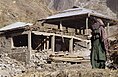
Balakot is a town in Mansehra district, Khyber Pakhtunkhwa, Pakistan. The town was significantly damaged during the 2005 Kashmir earthquake but was later rebuilt with the assistance of the Government of Pakistan.

<span class="mw-page-title-main">International response to the 2005 Kashmir earthquake</span> Worldwide humanitarian response to the 2005 Kashmir earthquake in Pakistan, Afghanistan and India

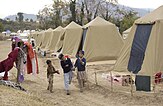
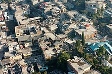
The international response to the 2005 Kashmir earthquake was widespread and immediate, as many countries, international organizations and non-governmental organizations offered an abundance of relief aid to the affected regions − particularly Pakistan, which was hit the hardest due to the earthquake's epicentre being around Muzaffarabad, the capital city of Pakistani-administered Azad Jammu and Kashmir. The aid given was in the form of monetary donations and pledges, as well as relief supplies including food, various medical supplies, tents and blankets. Rescue and relief workers as well as peacekeeping troops were sent from different parts of the world to the region, bringing along rescue equipment, including helicopters and rescue dogs. The earthquake displaced some 3.3 million people, while killing around 80,000–100,000.

The 2005 Hindu Kush earthquake hit northeastern Afghanistan with a magnitude of 6.5 on December 12 at 21:47 (UTC). According to the United States Geological Survey, the maximum Mercalli intensity was V (Moderate) at Chitral. Five people were killed in the Hindu Kush region and landslides blocked several roads near Bagh, Kashmir. The earthquake occurred some 65 miles away from Faizabad, a city in the Hindu Kush mountains, but it could be felt in many neighboring areas. It could even be felt about 200 miles away in Islamabad, Pakistan. The quake was strong enough to trigger panic among survivors of October's devastating earthquake, who came out from their makeshift shelters in freezing temperatures. Although magnitude–6 earthquakes typically cause severe damage, this quake caused relatively little due to the fact that it occurred deep underground.

<span class="mw-page-title-main">Bagh, Azad Kashmir</span> City in Azad Kashmir, Pakistan

Bagh City is the chief town and district headquarters of Bagh District, in Azad Kashmir, Pakistan. The town is situated on the confluence of two nullahs (streams), Malwani and Mahl at a distance of 93 km from Muzaffarabad.

<span class="mw-page-title-main">Neelum River</span> River in India and Pakistan

The Neelum River, or Kishanganga River, is a river in the Kashmir region of Pakistan and India. It originates in Ganderbal district of Jammu and Kashmir in India, flows through the Neelam Valley in Pakistan's Azad Kashmir, where parts of its course fall along the Line of Control, before merging with the Jhelum River near the city of Muzaffarabad.

The 2006 Kīholo Bay earthquake occurred on October 15 at 07:07:49 local time with a magnitude of 6.7 and a maximum Mercalli intensity of VIII (Severe). The shock was centered 21 kilometers (13 mi) southwest of Puakō and 21 km (13 mi) north of Kailua-Kona, Hawaiʻi, just offshore of the Kona Airport, at a depth of 38.2 km (23.7 mi). It produced several aftershocks, including one that measured a magnitude of 6.1 seven minutes after the main shock. The Pacific Tsunami Warning Center measured a nondestructive tsunami of 4 in (100 mm) on the coast of the Big Island.

<span class="mw-page-title-main">Neelum District</span> District of Azad Kashmir, Pakistan

Neelum is a district of Pakistan-administered Azad Kashmir in the disputed Kashmir region. It is the northernmost of 10 districts located within the Pakistani-administered territory of Azad Kashmir. Taking up the larger part of the Neelum Valley, the district had a population of around 191,000 people. It was among the worst-hit areas of Pakistan during the 2005 Kashmir earthquake.

The 2013 Balochistan earthquakes took place in late September in southwestern Pakistan. The mainshock had a moment magnitude of 7.7 and a maximum Mercalli intensity of IX (Violent). At least 825 people were killed and hundreds more were injured. On 28 September, a M6.8 aftershock occurred to the north at a depth of 14.8 kilometres, killing at least 22 people.

<span class="mw-page-title-main">Azad Jammu Kashmir Medical College</span>

Azad Jammu Kashmir Medical College or (AJKMC) is a public medical institute located in Muzaffarabad, Azad Jammu & Kashmir, Pakistan. AJKMC is home to 500 students in the MBBS program, with clinical rotations occurring at Combined Military Hospital Muzaffarabad and Abbas Institute of Medical Sciences. AJKMC was established in 2011. It is recognized by the Pakistan Medical and Dental Council.

<span class="mw-page-title-main">October 2015 Hindu Kush earthquake</span> Earthquake in Pakistan, Afghanistan and India

The October 2015 Hindu Kush earthquake was a magnitude 7.5 earthquake that struck South Asia on 26 October 2015, at 13:39 AFT with the epicenter 45 km north of Kuran wa Munjan, Afghanistan, at a depth of 231.0 km.

The December 2015 Hindu Kush earthquake occurred with a moment magnitude of 6.3 in South Asia on 25 December 2015. One woman was killed in Pakistan. At least 100 people were injured in Pakistan and Afghanistan. The quake was also strongly felt in Tajikistan and India. The epicenter of the earthquake was in the Afghanistan-Tajikistan border region at a depth of 203.4 km.

The 1992 Murindó earthquake occurred on October 18 at 15:11 UTC with an epicenter in the Department of Chocó, northern Colombia. The shallow magnitude 7.2 earthquake struck northwest of the town of Murindó, killing ten and injured more than a hundred. Thirty-three municipalities were severely damaged.

<span class="mw-page-title-main">2017 Iran–Iraq earthquake</span> November 2017 earthquake near the Iran–Iraq border

On 12 November 2017 at 18:18 UTC, an earthquake with a moment magnitude of 7.3 occurred on the Iran–Iraq border, with the Iraqi Kurdish city of Halabja, and the Kurdish dominated places of Ezgeleh, Salas-e Babajani County, Kermanshah Province in Iran, closest to the epicentre, 30 kilometres (19 mi) south of the city of Halabja, Iraqi Kurdistan.

<span class="mw-page-title-main">2019 Kashmir earthquake</span> Earthquake in Kashmir

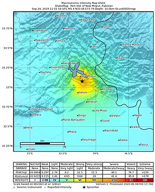
The 2019 Kashmir earthquake struck regions of Pakistan with an epicentre in Azad Kashmir on 24 September at 16:02 local time. It had a magnitude of 5.4 Mww and a maximum felt intensity of VII on the Modified Mercalli intensity scale or VIII on the European macroseismic scale. There was severe damage in Mirpur District, causing the deaths of 40 people and injuring a further 850. The epicentre of the shallow quake was near the city of Mirpur, Pakistan. The tremors were felt in the Kashmir region, Punjab (Pakistan), Punjab (India), Uttarakhand and northern parts of India including New Delhi.

<span class="mw-page-title-main">2021 Balochistan earthquake</span> Earthquake near Harnai, Pakistan

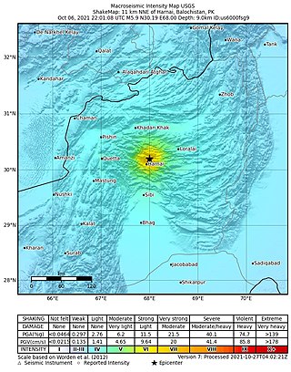
An earthquake struck Pakistan's province of Balochistan near the city of Harnai on 7 October 2021. The moment magnitude 5.9 Mww  quake struck in the early morning at 03:01 local time, killing at least 42 people and injuring 300 others. The earthquake occurred just one day before the anniversary of the 2005 Kashmir earthquake.

References

  1. 1 2 3 ISC (2014), ISC-GEM Global Instrumental Earthquake Catalogue (1900–2009), Version 1.05, International Seismological Centre, archived from the original on 25 November 2016, retrieved 25 March 2015
  2. 1 2 Zahid Ali; Muhammad Qaisar; Tariq Mahmood; Muhammad Ali Shah; Talat Iqbal; Leonello Serva; Alessandro M. Michetti; Paul W. Burton (2009). "The Muzaffarabad, Pakistan, earthquake of 8 October 2005: surface faulting, environmental effects and macroseismic intensity". Special Publications. 316 (1). The Geological Society of London: 155–172. Bibcode:2009GSLSP.316..155A. doi:10.1144/SP316.9. S2CID   128469925. Archived from the original on 27 June 2022. Retrieved 7 October 2021.
  3. Bulmer, M.; Farquhar, T.; Roshan, M.; Akhtar, S. S.; Wahla, S. K. (2007), "Landslide hazards after the 2005 Kashmir earthquake", EOS, 88 (5): 53–68, Bibcode:2007EOSTr..88...53B, doi:10.1029/2007eo050001, S2CID   140661236
  4. USGS. "M5.9 - Pakistan". United States Geological Survey.
  5. USGS. "M5.8 - Pakistan". United States Geological Survey. Archived from the original on 14 December 2018. Retrieved 28 August 2017.
  6. USGS. "M6.4 - Pakistan". United States Geological Survey. Archived from the original on 10 October 2016. Retrieved 28 August 2017.
  7. 1 2 3 USGS (4 September 2009), PAGER-CAT Earthquake Catalog (Earthquake ID 20051008035040), Version 2008_06.1, United States Geological Survey, archived from the original on 15 January 2018, retrieved 27 November 2018
  8. "The great Quetta tragedy". DAWN Newspaper. 25 October 2005. Archived from the original on 27 October 2005. Retrieved 24 January 2022.
  9. 1 2 "First Report on the Kashmir Earthquake of October 8, 2005" (PDF). eeri.org. Archived from the original (PDF) on 29 June 2006.
  10. "Today in Earthquake History". Archived from the original on 6 September 2024. Retrieved 10 September 2023.
  11. "Pak in panic as quake rocks Kashmir" Archived 8 December 2015 at the Wayback Machine Reuters, The Financial Express, 19 October 2005. Retrieved 23 February 2006.
  12. "Pakistan: A summary report on Muzaffarabad earthquake" Archived 9 February 2006 at the Wayback Machine ReliefWeb, 7 November 2005. Retrieved 23 February 2006.
  13. BBC series: Earth: The Power of the Planet., part 1. Volcano
  14. Mahmood, I.; Qureshi, S. N.; Tariq, S.; Atique, L.; Iqbal, M. F. (2015). "Analysis of Landslides Triggered by October 2005, Kashmir Earthquake". PLOS Currents. 7: ecurrents.dis.0bc3ebc5b8adf5c7fe9fd3d702d44a99. doi: 10.1371/currents.dis.0bc3ebc5b8adf5c7fe9fd3d702d44a99 . PMC   4556441 . PMID   26366324.
  15. Abbasi, Kashif (21 December 2019). "Only three multi-storey buildings operating with completion certificates". DAWN.COM. Archived from the original on 30 September 2023. Retrieved 7 February 2023.
  16. 1 2 3 4 "Big quake hits subcontinent; thousands feared dead". Reuters. 8 October 2005. Archived from the original on 13 October 2005. Retrieved 28 February 2023.
  17. "Thousands at risk of starving in earthquake aid shortfall" The Times, 21 October 2005. Retrieved 24 February 2006.
  18. Qayum, Khalid (26 October 2005), Pakistan Asks Quake Survivors to Leave Mountains Before Winter, Bloomberg News, archived from the original on 6 September 2024, retrieved 4 March 2017
  19. "Kashmir earthquake of 2005". October 2023. Archived from the original on 6 September 2024. Retrieved 27 March 2021.
  20. "Twenty-two tetanus deaths reported in Pakistan quake zone". The New York Times. 27 October 2005. Archived from the original on 1 September 2021. Retrieved 27 March 2021.
  21. "pakistan toll at 38000 is expected to rise". Archived from the original on 6 September 2024. Retrieved 27 March 2021.
  22. "Pakistan puts quake toll at 18,000". CNN. 9 October 2005. Archived from the original on 10 August 2024. Retrieved 10 August 2024.
  23. Amr S. Elnashai (6 November 2006). "The Pakistan Earthquake of October 2005: A Reminder of Human-Science Interaction in Natural Disasters Risk Management". The Illinois International Review. Archived from the original on 29 October 2007. Retrieved 16 March 2009.
  24. "Pakistan Asks Quake Survivors to Leave Mountains Before Winter" Archived 6 September 2024 at the Wayback Machine ( Bloomberg News ), 26 October 2005. Retrieved 24 February 2006.
  25. "New figures put quake toll at more than 79,000" Archived 2 November 2020 at the Wayback Machine AP, NBC News, 19 October 2005. Retrieved 23 February 2006.
  26. "South Asia Earthquake: Fact Sheet #25 (FY 2006)" Archived 9 February 2006 at the Wayback Machine ReliefWeb , 17 November 2005. Retrieved 23 February 2006.

Further reading