Gathering a sizable force, Zabardast Khan declared independence and planned an invasion of the Kashmir Valley. In response, Diwan Kirpa Ram led a large Khalsa army to suppress the rebellion. Between Baramulla and Muzaffarabad, across a span of nearly 77 miles, Zabardast Khan's forces—supported by the local Muslim population—launched persistent attacks on the advancing Sikh army, employing guerrilla tactics from caves, rocks, and forests. The Sikh forces suffered heavy casualties, and Diwan Kirpa Ram's army faced serious defeats and significant losses.[10]
Dogra era
On 28 May 1849 James Abbott, at the time boundary commissioner, wrote that "intelligence received from Cashmere that a Jumboo Force of 4,000 men is about to march to Moozuffurabad, where there are already 3,000. This report may be a feint of the Maharaja to overcome the hill tribes, who, though quite peaceful at present, have been much opprest [sic] and are ready enough to rise when opportunity offers."[11]
Abbott also wrote that it is "highly desirable therefore that this report, which has greatly alarmed them and may drive them to desperation, be contradicted; and I have accordingly addrest the Maharaja disclaiming belief in such a rumour, and assuring him that any movement of troops in this direction at this moment will not have a friendly aspect. The assembly of any force upon the frontier were an encouragement to the insurgents in Mooltan and to others who are disposed to join them."[11]
The following day on 29 May Abbott wrote:
I had not understood yesterday that another Jumboo force was said to be about to march from Cashmere upon Kurnao, a district between the Cashmere river and the Kishengunga. This Force is rated at 6,000. The mountaineers anxiously enquire of me whether they may not defend themselves from this invasion. I have declined putting any restraint upon their measures of self defence, assuring them, however, that any rising, excepting to resist invasion, would subject them to the displeasure of the British Government. If they can act in concert, they ought to be able to destroy this force, large as it is, their country being strong and the whole population bearing arms.
If these military movements are really contemplated, they are highly objectionable at this season, and of a most suspicious character. The information is the best I can command, and agrees perfectly with the manifest apprehension of the Jumboo Moonshee in my camp. The Maharaja would plead his right to move his troops wheresoever he pleases within his own kingdom, but he is perfectly well aware of the sensation they will create in the Punjaub.[11]
The Battle of Muzaffarabad occurred on 22 October 1947 between Pakistani-backed Pashtun tribesmen, pro-Pakistani Kashmiri rebels, and the Jammu and Kashmir State Forces in the town of Muzaffarabad. The battle resulted in a rapid defeat of the Jammu and Kashmir State Forces, leading to the capture of Muzaffarabad by the tribesmen.
The city was near the epicenter of the 2005 Kashmir earthquake, which had a magnitude of 7.6 Mw. The earthquake destroyed about 50 percent of the buildings in the city (including most government buildings) and is estimated to have killed up to 80,000 people in the Pakistani-controlled areas. As of 8October2005[update], the Pakistani government's official death toll was 87,350, while other estimates have put the death toll at over 100,000.[12]
According to the Government Published Azad Kashmir 2020 Statistical Year Book, the approximate spoken languages breakdown of Muzaffarabad District is 50% Pahari (including all dialects), 35% Gojri, and 15% Kashmiri.[15]
Muzaffarabad's public transportation system primarily relies on buses, rickshaws, and small pickup trucks for intracity travel. Following the devastating 2005 earthquake that severely damaged infrastructure, including roads, the city government, with international aid, rebuilt roads, bridges, and other essential infrastructure. However, public transportation remains underdeveloped. Notably, Muzaffarabad lacks a railway system and a functional airport. The nearest railway station is located in the Rawalpindi District of Pakistani Punjab.[16]
Education
Muzaffarabad is the educational hub of Azad Kashmir, hosting several private and public institutions. The education sector in the city is administered by the Government of Azad Jammu & Kashmir. The region has a literacy rate of approximately 77.5% which is significantly higher than the national average of Pakistan.[17] Following the 2005 Kashmir earthquake, which destroyed a significant portion of the city's educational infrastructure, major reconstruction projects were launched to rebuild schools and university campuses. According to the Earthquake Rehabilitation and Reconstruction Authority (ERRA), 7,608 post-earthquake reconstruction projects were planned under three implementation channels: sponsor-funded, donor-funded, and Government of Pakistan–funded.[18] While sponsor- and donor-funded projects were completed, 1,730 Government of Pakistan–funded projects, including 1,112 in education, remained incomplete by 2010 due to funding shortfalls.[18]
Higher Education
The primary institution of higher learning in the city is the University of Azad Jammu & Kashmir (UAJK). Established in 1980, it is a multi-campus public university, offering undergraduate and postgraduate programs across a range of disciplines.[19] The main campus is located in Muzaffarabad[19], with additional facilities at the King Abdullah Campus in Chatter Class, which was constructed after the 2005 earthquake as part of the reconstruction of the region's higher education infrastructure.[20]
The King Abdullah Campus was inaugurated in 2023 following a grant of approximately US$90 million from the Saudi Fund for Development.[21] The campus includes around 15 academic departments, administrative blocks, a library, auditorium, and student accommodation facilities. Around 10,000 students are expected to benefit from the facility.[21]
↑Snedden (2013, p.176): On p.29, the census report states that Urdu is the official language of the government of Azad Kashmir, with Kashmiri, Pahari, Gojri, Punjabi, Kohistani, Pushto, and Sheena 'frequently spoken in Azad Kashmir'. Yet, when surveyed about their 'mother tongue', Azad Kashmiris' choices were limited to selecting from Pakistan's major languages: Urdu, Punjabi, Sindhi, Pushto, Balochi, Saraiki, and 'others'; not surprisingly, 2.18 million of Azad Kashmir's 2.97 million people chose 'others'.
References
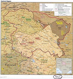
12The application of the term "administered" to the various regions of Kashmir and a mention of the Kashmir dispute is supported by the tertiary sources (a) through (e), reflecting due weight in the coverage. Although "controlled" and "held" are also applied neutrally to the names of the disputants or to the regions administered by them, as evidenced in sources (h) through (i) below, "held" is also considered politicized usage, as is the term "occupied," (see (j) below). (a) Kashmir, region Indian subcontinent, Encyclopaedia Britannica, retrieved 15 August 2019 (subscription required) Quote: "Kashmir, region of the northwestern Indian subcontinent ... has been the subject of dispute between India and Pakistan since the partition of the Indian subcontinent in 1947. The northern and western portions are administered by Pakistan and comprise three areas: Azad Kashmir, Gilgit, and Baltistan, the last two being part of a territory called the Northern Areas. Administered by India are the southern and southeastern portions, which constitute the state of Jammu and Kashmir but are slated to be split into two union territories."; (b) Pletcher, Kenneth, Aksai Chin, Plateau Region, Asia, Encyclopaedia Britannica, retrieved 16 August 2019 (subscription required) Quote: "Aksai Chin, Chinese (Pinyin) Aksayqin, portion of the Kashmir region, at the northernmost extent of the Indian subcontinent in south-central Asia. It constitutes nearly all the territory of the Chinese-administered sector of Kashmir that is claimed by India to be part of the Ladakh area of Jammu and Kashmir state."; (c) "Kashmir", Encyclopedia Americana, Scholastic Library Publishing, 2006, p.328, ISBN978-0-7172-0139-6 C. E Bosworth, the University of Manchester Quote: "KASHMIR, kash'mer, the northernmost region of the Indian subcontinent, administered partlv by India, partly by Pakistan, and partly by China. The region has been the subject of a bitter dispute between India and Pakistan since they became independent in 1947"; (d) Osmańczyk, Edmund Jan (2003), Encyclopedia of the United Nations and International Agreements: G to M, Taylor & Francis, pp.1191–, ISBN978-0-415-93922-5 Quote: "Jammu and Kashmir: Territory in northwestern India, subject to a dispute between India and Pakistan. It has borders with Pakistan and China." (e) Talbot, Ian (2016), A History of Modern South Asia: Politics, States, Diasporas, Yale University Press, pp.28–29, ISBN978-0-300-19694-8 Quote: "We move from a disputed international border to a dotted line on the map that represents a military border not recognized in international law. The line of control separates the Indian and Pakistani administered areas of the former Princely State of Jammu and Kashmir."; (f) Skutsch, Carl (2015) [2007], "China: Border War with India, 1962", in Ciment, James (ed.), Encyclopedia of Conflicts Since World War II (2nded.), London and New York: Routledge, p.573, ISBN978-0-7656-8005-1, The situation between the two nations was complicated by the 1957–1959 uprising by Tibetans against Chinese rule. Refugees poured across the Indian border, and the Indian public was outraged. Any compromise with China on the border issue became impossible. Similarly, China was offended that India had given political asylum to the Dalai Lama when he fled across the border in March 1959. In late 1959, there were shots fired between border patrols operating along both the ill-defined McMahon Line and in the Aksai Chin. (g) Clary, Christopher (2022), The Difficult Politics of Peace: Rivalry in Modern South Asia, Oxford and New York: Oxford University Press, p.109, ISBN9780197638408, Territorial Dispute: The situation along the Sino-Indian frontier continued to worsen. In late July (1959), an Indian reconnaissance patrol was blocked, "apprehended," and eventually expelled after three weeks in custody at the hands of a larger Chinese force near Khurnak Fort in Aksai Chin. ... Circumstances worsened further in October 1959, when a major class at Kongka Pass in eastern Ladakh led to nine dead and ten captured Indian border personnel, making it by far the most serious Sino-Indian class since India's independence. (h) Bose, Sumantra (2009), Kashmir: Roots of Conflict, Paths to Peace, Harvard University Press, pp.294, 291, 293, ISBN978-0-674-02855-5 Quote: "J&K: Jammu and Kashmir. The former princely state that is the subject of the Kashmir dispute. Besides IJK (Indian-controlled Jammu and Kashmir. The larger and more populous part of the former princely state. It has a population of slightly over 10 million, and comprises three regions: Kashmir Valley, Jammu, and Ladakh.) and AJK ('Azad" (Free) Jammu and Kashmir. The more populous part of Pakistani-controlled J&K, with a population of approximately 2.5 million.), it includes the sparsely populated "Northern Areas" of Gilgit and Baltistan, remote mountainous regions which are directly administered, unlike AJK, by the Pakistani central authorities, and some high-altitude uninhabitable tracts under Chinese control." (i) Fisher, Michael H. (2018), An Environmental History of India: From Earliest Times to the Twenty-First Century, Cambridge University Press, p.166, ISBN978-1-107-11162-2 Quote: "Kashmir’s identity remains hotly disputed with a UN-supervised “Line of Control” still separating Pakistani-held Azad (“Free”) Kashmir from Indian-held Kashmir."; (j) Snedden, Christopher (2015), Understanding Kashmir and Kashmiris, Oxford University Press, p.10, ISBN978-1-84904-621-3 Quote:"Some politicised terms also used to describe parts of J&K. These terms include the words 'occupied' and 'held'."
123JOURNALS AND DIARIES OF THE ASSISTANTS TO THE RESIDENT AT LAHORE – No 33—Diary of Captain James Abbott, Assistant Resident, on deputation to Huzara, for the 28th and 29th May 1848. This article incorporates text from this source, which is in the public domain.
This page is based on this Wikipedia article Text is available under the CC BY-SA 4.0 license; additional terms may apply. Images, videos and audio are available under their respective licenses.

 Heightened view of the city on both riverbanks after the 2005 Kashmir earthquake, c. 2014
 Photo of Muzaffarabad Cricket Stadium
 Photo of the city's skyline, c. 2017
 Azad Jammu Kashmir Medical College
 Muzaffarabad City, Azad Kashmir, Pakistan