Mansehra
| |
---|---|
Coordinates: 34°20′2″N73°12′5″E / 34.33389°N 73.20139°E | |
Country | Pakistan |
Province | Khyber Pakhtunkhwa |
District | Mansehra |
Tehsil | Mansehra |
Region | Upper Pakhli |
Area | |
• Total | 1,340 km2 (520 sq mi) |
Elevation | 1,088 m (3,570 ft) |
Population | |
• Total | 127,623 |
• Rank | 71st in Pakistan 7th in Khyber Pakhtunkhwa |
• Density | 340/km2 (900/sq mi) |
Demonym | Mansehri or Mansehrian |
Time zone | UTC+5 (PST) |
Postal Code | 21300 |
Mansehra is a city in the Khyber Pakhtunkhwa province of Pakistan and the headquarters of Mansehra District. It is the 71st largest city in Pakistan by population and the 7th largest city in the province.
The name of the city is derived from the name of its founder, Mahan Singh, who was an administrator in the Sikh Army during the rule of Ranjit Singh. [3] The city hosts the Mansehra Shiva Temple, which is famous for its annual Shivarathri festival. [4]
With the rise of Chandragupta Maurya, the region came under the complete control of the Mauryan Empire. Ashoka governed this area as a prince on the imperial throne in c. 272 BCE. he made it one of the major seats of his government. The Edicts of Ashoka, inscribed on three large boulders near Mansehra record fourteen of Ashoka's edicts, presenting aspects of the emperor's dharma or righteous law. These represent some of the earliest evidence of deciphered writing in the subcontinent, dating to the middle of the third century BCE, and are written from right to left in the Kharosthi script. [5]
The region was briefly and nominally controlled by many foreign rulers, including the Indo-Parthians, Indo-Scythians, and Kushans, who promoted Dharmic religions throughout Central and South Asia. The region reached its height under the Buddhist ruler Kanishka the Great.
During the period,Buddhist art and architecture flourished in the area. [6]
With the decline of the imperial Guptas, the Hindu Shahis came to rule the area. The Hindu Shahis built two massive forts on the northern edges of the region. The forts were later renamed as "Kafirkots" (forts of the infidel). These Hindu Shahi forts were known for high towers and steep defensive walls. The Hindus also built many Hindu temples around the area, however, much of them are now in rubble. The Hindu Shahis remained in control of the area until their defeat by the Ghaznavids in the year 1001. [6]
Pakhli Sultanate (1190-1399):
This area was conquered by Sultan Pakhal Swati in 1190 who established the rule by driving out the Bambas and Ghakars rulers of this area. [7] It remained part of Sultanate of Swat also known as Pakhli Sultanate until 1399.
Pakhli Sarkar(1399-1703):
The Timiurids attacked this side of Swat Sultanate in 1370 and established their Sarkar here. The Timiurids gave Sarkar to their subjects called Hazara Turks or Karluk Turks after whom the name of Hazara Division is derived. They ruled until 1703. The last ruler was Sultan Mehmood Khurd. This Sultanate is referred as Pakhli Sarkar in Mughal documents because this area was taken from Sultan Pakhal Swati's Sultanate so the name continued on by Turks.
2nd Invasion of Swatis in 1703:
Swati's Sultanate of Swat was ended in 1519 after being defeated by Yousafzais. Swatis were finding a area to live peacefully again. In 1703, Swatis under the leadership of Syed Jalal Baba conquered Pakhli and ousted Turks. Saadaat Khan Swati was chosen as Chief of Swati tribe and the whole Pakhli was equally divided among the 3 clans of Swatis. At that time Pakhli was composed of the all areas of today's District Mansehra and District Battagram.
Pakhli State(1768-1818):
Ahmad Shah Durrani invaded the region with Timur Shah Durrani. Under Durrani Rule, the Chief of Swati tribe Saadaat Khan Swati was chosen as 1st Chief of Pakhli [8] . [9] Durrani rule was interrupted by the Maratha Empire's under Raghunathrao, who drove out the Afghans, [10] Following the Third Battle of Panipat, Ahmad Shah Durrani defeated the Marathas and recaptured Lahore, Sikh forces occupied the region after the Durranis withdrew. The Durranis invaded two more times, while the Sikhs would re-occupy the region after both invasions. [9]
Sikh Rule(1818-1831)
The fall of the Durrani Empire made way for the Sikhs to rise to power under Ranjit Singh. The Sikhs gained control of the area in 1818 by defeating Habibullah Khan Swati I who was the 2nd and last ruler of Pakhli State. The town of Pakhli which is now called Mansehra was founded by Mahan Singh Mirpuri, a Sikh governor. [11] [12] There were popular uprisings against Sikh rule, but these uprisings failed and the Sikhs remained in power until 1849 when the area came under British rule. [12] [ self-published source ] [13] [14] [15]
By 1849, the British had gained control of all of Mansehra. To maintain peace in the area, the British took preventive measures by co-opting the local chiefs.
Khan Jummah Khan Jehangiri Swathi was the Khan of Mansehra city under British rule. [16] Atta Muhamad Khan Swathi was the chief of Agror Valley, Lal Khan Sarkheli Swathi was the Chief of Balakot, Samundar Khan Swathi was Khan of Garhi Habibullah while Wali Muhammad Khan Jehangiri Swathi was the Wali of Ogra and Konsh Valley. [16]
The British divided Hazara region into three tehsils (administrative subdivisions): Mansehra, Abbottabad, and Haripur. In 1901, when the British formed the buffer province of North West Frontier Province (NWFP), Hazara was annexed into it.
During British rule, Mansehra was a small town. Its population according to the 1901 census was 5,087. [17] During the British period, Mansehra was the headquarters of Mansehra Tehsil.
In 1976 Mansehra Tehsil was made district and Mansehra became the centre of it.
Mansehra City is the administrative capital of District and Tehsil Mansehra. The City of Mansehra is administratively divided into four Union Councils: [18] Mansehra City Wards No. 1–4 and Mansehra (Rural)/suburban. Each union council is divided into Mohallas.
During the festival of Durgashtami, held in the first month of the Hindu calendar and the seventh month of the Nanakshahi calendar, [19] about 400 local Hindus assembled on Bareri Hill to worship Devi (as Durga). Offerings were taken by a Brahmin of Mansehra. [19] The assembly on each occasion lasted only one day. [19] The site is ancient, as at the base of Bareri Hill are the boulders inscribed with the Edicts of Ashoka. [20]
Khans also known as Nawabs of Mansehra (city only) are following : [21]
No | Khan | Reign | Notes |
---|---|---|---|
1 | Khan Sardar Khan Jahangiri Swati | 1703-1751 | Khan-E-Awal Mansehra right after the Conquest of Pakhli |
2 | Khan Suddam Khan Jahangiri [22] | 1751-1795(died) | 2nd Khan Of Mansehra, son of Sardar Khan |
3 | Khan Zaman Khan Jahangiri [23] | 1795- 1881(died) | 3rd Khan of Mansehra, Known for resistance against Sikh rule , son of Suddam Khan |
4 | Khan Juma Khan Jahangiri | 1881- 1910 | Son of Zaman Khan, British terminated his Khanate |
5 | Khan Bahadur Raja Ali Gohar Khan Jahangiri | 1925-1948 | Restored Khanate, MLA, Governor Srinagar, Agriculture Minister Kashmir(princely state), Khan Bahadur, Raja |
6 | Khan Tariq Khan Jahangiri [24] | 1948-Present | Minister KPK, 3 times elected MPA of Mansehra |
Khan Muhammad Tariq Khan Swati has been MPA of Mansehra from 1990-2002 and minister of KPK. Khan Ali Gohar Khan was the agriculture minister of Kashmir before partition, deputy commissioner and acting governor of Srinagar. He was awarded the title of "Khan Bahadur" by British Viceroy and title of "Raja" by Maharaja Hari Singh of Kashmir. MPA of Mansehra, Babar Saleem Swati also belongs to the same family. He is the great grandson of 4th Khan Of Mansehra, Jummah Khan. Khurram Khan, a well known Politician of Mansehra also belongs to same family and is the great great grandson of 3rd "Khan Of Mansehra", Zaman Khan. Zaman Khan Jehangiri was well known for his resistance against Maharaja Ranjeet Singh armies in Hazara.
Khyber Pakhtunkhwa, formerly known as North West Frontier Province, is a province of Pakistan. Located in the northwestern region of the country, Khyber Pakhtunkhwa is the fourth largest province of Pakistan by land area and the third-largest province by population. It is bordered by the Pakistani provinces of Balochistan to the south, Punjab to the south-east, the territory of Gilgit-Baltistan to the north and north-east, Islamabad Capital Territory to the east and Azad Kashmir to the north-east. It shares an international border with Afghanistan to the west. Khyber Pakhtunkhwa has a varied landscape ranging from rugged mountain ranges, valleys, plains surrounded by hills, undulating submontane areas and dense agricultural farms.
The North-West Frontier Province was a province of British India from 1901 to 1947, of the Dominion of Pakistan from 1947 to 1955, and of the Islamic Republic of Pakistan from 1970 to 2010. It was established on 9 November 1901 from the north-western districts of the British Punjab, during the British Raj. Following the referendum in 1947 to join either Pakistan or India, the province voted hugely in favour of joining Pakistan and it acceded accordingly on 14 August 1947. It was dissolved to form a unified province of West Pakistan in 1955 upon promulgation of One Unit Scheme and was reestablished in 1970. It was known by this name until 19 April 2010, when it was dissolved and redesignated as the province of Khyber Pakhtunkhwa following the passing of the Eighteenth Amendment to the Constitution of Pakistan, by erstwhile President Asif Ali Zardari.
Abbottabad District is a district in the Khyber Pakhtunkhwa province of Pakistan. It is part of the Hazara Division and Hazara region covers an area of 1,969 km2, with the city of Abbottabad being the principal town. Neighbouring districts include Mansehra to the north and Haripur to the west in Khyber Pakhtunkhwa, Muzaffarabad to the east in Azad Jammu and Kashmir and Rawalpindi to the south in the Punjab province.
Mansehra District is a district in the Hazara Division, Khyber Pakhtunkhwa, northern Pakistan. Mansehra city serves as the headquarters of the district.
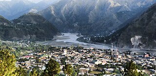
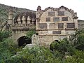
Amb or the State of Amb was a princely state in the present day Khyber Pakhtunkhwa region of Pakistan. Together with Phulra, it was known as Feudal Tanawal ruled by Tanoli tribe. A Royal Tenure start from Timurid Empire and end on Last Nawab Muhammad Farid Khan Tanoli. Amb was only powerful state incorporated in Pakistan with armed civilized military of 12,000 men, 300 Howitzer with their own manufacturing arms factory, today part of the Pakistan Army. Amb had a influence control roots in Swat, Dir and Chitral. A gaining of powerful roots of Amb military start from Second Anglo-Sikh War when East India Company provide military equipment to Jehandad Khan Tanoli to fight against Sikh, and then next British Empire in Second anglo-Afghan War. At the end of December 1947, the Nawab of Amb state acceded to Pakistan while retaining internal self-government. Amb continued as a princely state of Pakistan until 1969, when it was incorporated into the North West Frontier Province.
Hazara is a region in northern Pakistan, falling administratively within Hazara Division of the Khyber Pakhtunkhwa province. It is dominated mainly by the Hindko speaking Hazarewal people, who make up the many native ethnic groups of the region and often called the "Hazarewal".
Gujrat is a district in the Pakistani province of Punjab. It is geographically located between the Chenab and Jhelum rivers and headquartered at the city of Gujrat.
The valley of Agror is located in the Hazara region of the Khyber-Pakhtunkhwa province of northern Pakistan. Its territory makes up Oghi Tehsil, an administrative unit of Mansehra District. Khans of Agror belonging to Begal subsection of Mitravi Swatis are ruling this area since 1703 conquest of Pakhli. Agror is the Pashto speaking area where Swatis speak pashto as their mother tongue.
Sherwan is a Tehsil from the Abbottabad District in the Khyber-Pakhtunkhwa province of Pakistan, located 35 km west of Abbottabad. Sherwan consists of two adjacent villages. The northern part is referred to as Sherwan Kalan, and the southern as Sherwan Khurd. Sherwan is on a ridge 5,000 feet high in the centre of Lower Tanawal.
Banda Pir Khan is one of the 51 union councils of Abbottabad District in Khyber-Pakhtunkhwa, Pakistan.
Dhodial is a town and union council located near Baffa between Mansehra and Shinkiari in Mansehra District in Khyber Pakhtunkhwa province of Pakistan. Dhodial is a fertile region known for its vegetables and tobacco crop. Dhodial is also well known for its pheasant conservation project. The town was badly affected by the 2005 Pakistan earthquake.
'Siran Valley is a beautiful valley situated near the banks of Siran River in Pakhli region of District Mansehra, Khyber Pakhtoon Khwa, Pakistan. Swati is the biggest landlord family of this Valley. Siran valley consists of many union councils including Bhogarmang and Sacha Kalan.
Garhi Habibullah is a town and union council of Mansehra District in the Khyber-Pakhtunkhwa province of Pakistan. It is located in Balakot Tehsil and lies to the east of district capital Mansehra, towards the Kashmir frontier. It was affected by the 2005 Kashmir earthquake. Garhi Habibullah is basically divided into 5 separate Khanates. 1) Khanate of Samundar Khan Khankhail Swati, Khanate of Habib Khan Jehangiri Swati, Khanate of Ameen Khan Jehangiri Swati, Khanate of Hassan Ali Khan Arghushal Swati and Khanate of Behram Khan Sarkheli Swati.
The History of Khyber Pakhtunkhwa refers to the history of the modern-day Pakistani province of Khyber Pakhtunkhwa.
Battagram Tehsil is an administrative subdivision (Tehsil) of the Battagram District in the Khyber Pakhtunkhwa province of Pakistan. It serves as the Tehsil headquarters and covers a total area of 300 square miles (780 km2). Battagram Tehsil merged into Pakistan as an administrative region before being raised to the status of a district in 1993. On October 8, 2005, a 7.6 magnitude earthquake in Kashmir badly affected the area.
Hazarewals or Hazarawals also known as Hazara is term used for the multi-ethnic predominantly Hindko and Shina speaking community belonging to the Hazara region of Khyber Pakhtunkhwa.
Baffa Pakhal is the fourth tehsil of Mansehra District in Khyber Pakhtunkhwa province of Pakistan. . The capital of Baffa pakhal is Baffa. Baffa Pakhal has at least 15 union councils, some of which are Dodial, Shinkiari, Suma Allimung, Schain, Jabar Daveli, Ichrian, Ail, Tanda, Baffa, Anayatabad, Hilkot, Tarangri Sabir Shah and Bhogarmang. Main language of the tehsil is Pashto followed by Hindko. Majority of lands in all Union Councils of Baffa Pakhal belongs to 8 families of Gabri Swatis.
Babar Saleem Khan Swati is a Pakistani politician and landlord who is the Speaker of the Provincial Assembly of Khyber Pakhtunkhwa since 29 February, 2024. He is member of the Provincial Assembly of Khyber Pakhtunkhwa from the constituency PK -37 Mansehra -II. Previously, he was a member of the Provincial Assembly from 2018 to 2022 and served as Advisor to the Chief Minister on Home and Tribal Affairs from October 2022 till January 2023. He belongs to the Jehangiri family within the Swati tribe of Mansehra.
Hinduism is a minority religion in the Khyber Pakhtunkhwa province followed by 0.02% of the population of the province as per 2017 Census.
Chiefs includes Khan Samundar Khan Swati of Garhi Habibullah—the Hereditary Chief of Swati tribe, Muhammad Husain Khan Swati— The Jageerdar of Mansehra , Atta Muhamad Khan Swati— the Chief of Agror Valley.
In the nearby locality of Bareri, Hindus from the vicinity, to the number of about 400, used to assemble at the top of Bareri hill to worship Devi (Durga) and to present offerings, which were taken by a Brahmin of Mansehra. The assembly on each occasion lasted only one day.
Further north; go to the black mountain near Oghi or to see the Asokan inscriptions on boulders near base of Bareri Hill close to Mansehra.