During the colonial era Hazara Division (then Hazara District) had been part of Peshawar Division[7] and was made up of three tehsils namely Haripur, Mansehra and Abbottabad [8] - following the dissolution of West Pakistan in 1970, Hazara District and the two tribal agencies were merged to create the new Hazara Division, with Abbottabad designated as its capital. Initially, the division comprised two districts: Abbottabad and Mansehra. Over the next few years, administrative changes led to the creation of two additional districts—Haripur was carved out of Abbottabad District, and Batagram was separated from Mansehra District.
Hazara functioned as a district until 1976, when it was formally upgraded to a division. In October of that year, Mansehra was granted full district status, encompassing the tehsils of Mansehra and Batagram. Later, in July 1991, Haripur Tehsil was separated from Abbottabad and established as an independent district. This left only the original Abbottabad Tehsil, which was then officially became Abbottabad District.
In 2000, Pakistan abolished its administrative divisions, elevating districts to serve as the new third tier of government. At the time of abolition, Hazara Division consisted of eight districts.[9]
However, in 2008, administrative divisions were reinstated, and Hazara Division was formally re-established.
Hazara Division Administrative Timeline with Tehsil Details
Year
Event
Tehsil Details
1970
Hazara District and two tribal agencies merged to form Hazara Division (capital: Abbottabad)
Hazara District included Abbottabad, Mansehra, and Haripur tehsils
1970s
Haripur District created from Abbottabad; Batagram District created from Mansehra
Haripur Tehsil became Haripur District; Batagram Tehsil separated from Mansehra
1976
Hazara formally upgraded to division status; Mansehra becomes a full district
Mansehra District comprised Mansehra and Batagram tehsils
1991
Haripur Tehsil separated from Abbottabad and made into a district
Abbottabad Tehsil was then split into Havelian and Abbottabad tehsils forming the tehsils of Abbottabad District
Hazara Division included Abbottabad, Mansehra, Haripur, Batagram, and later Kohistan and Torghar districts
Demographics
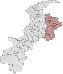
Population
According to the 2023 census, Hazara Division had a population of 6,188,736[10] roughly equal to the nation of Bulgaria[11] or the US state of Missouri.[12]
↑"About Hazara Division". Commissioner Hazara Division. Government of Khyber Pakhtunkhwa. Retrieved 28 October 2025. Note: Website message predates the creation of Allai District.
↑"About Hazara Division". Commissioner Hazara Division. Government of Khyber Pakhtunkhwa. Retrieved 28 October 2025.
↑"Imperial Gazetteer". Digital South Asia Library. University of Chicago. Retrieved 28 October 2025.{{cite web}}: Check |archive-url= value (help)CS1 maint: url-status (link)
↑Divisions/Districts of PakistanArchived 2006-09-30 at the Wayback Machine Note: Although divisions as an administrative structure had been abolished, the election commission of Pakistan still continued to group districts under the division names
↑Divisions/Districts of PakistanArchived 2006-09-30 at the Wayback Machine Note: Although divisions as an administrative structure has been abolished, the election commission of Pakistan still groups districts under the division names
This page is based on this Wikipedia article Text is available under the CC BY-SA 4.0 license; additional terms may apply. Images, videos and audio are available under their respective licenses.