Sargodha Division سرگودھا ڈویژن | |
|---|---|
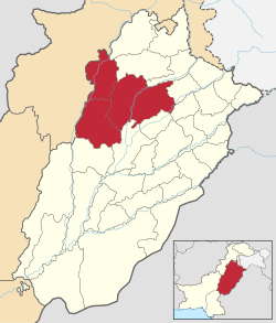
| Sargodha Division in Punjab | |
| Coordinates: 32°10′N72°30′E / 32.167°N 72.500°E | |
| Country | |
| Province | |
| Capital | Sargodha |
| Established | 1960 |
| Districts | 4 |
| Government | |
| • Type | Divisional Administration |
| • Divisional Commissioner | Dr Irshad Ahmed |
| • Regional Police Officer | N/A |
| Area | |
| 26,360 km2 (10,180 sq mi) | |
| Elevation | 155 m (509 ft) |
| Population (2023) | |
| 9,591,275 | |
| • Density | 363.86/km2 (942.4/sq mi) |
| • Urban | 2,744,219 (28.61%) |
| • Rural | 6,847,056 |
| Literacy | |
| • Literacy rate |
|
| Time zone | UTC+5 (PST) |
| Postal code | 40100 (Sargodha) 41000 (Khushab) 41000 (Mianwali) 41000 (Bhakkar) |
| Dialling code | 048 (Sargodha) 0454 (Khushab) |
| Website | sargodhadivision |
Sargodha Division is an administrative division of Punjab province, Pakistan. Sargodha city is the capital of the division. Divisions are the third tier of government below the federal and provincial levels.
In 2000, local government reforms abolished administrative divisions and raised the districts to the new third tier of government. [2] But in 2008, the division system was revived after the restoration of democratic government system. [3]
| Year | Pop. | ±% p.a. |
|---|---|---|
| 1951 | 1,835,178 | — |
| 1961 | 2,587,061 | +3.49% |
| 1972 | 3,218,873 | +2.01% |
| 1981 | 3,934,861 | +2.26% |
| 1998 | 6,101,052 | +2.61% |
| 2017 | 9,783,183 | +2.52% |
| 2023 | 11,416,686 | +2.61% |
| Sources: [4] | ||
According to 2023 census, Sargodha division had a population of 9,591,275, [5] roughly equal to the population of Sweden [6] or the US state of Michigan. [7] The literacy rate across the division stands at 63.19%, with males at 73.36% and females at 52.65%.
Sargodha division shares borders with Gujrat, Mianwali, Rawalpindi and Faisalabad divisions.
| # | District | Headquarter | Area (km²) [8] | Pop. (2023) [8] | Density (ppl/km²) (2023) [8] | Lit. rate (2023) |
|---|---|---|---|---|---|---|
| 1 | Sargodha | Sargodha | 5,854 | 4,334,448 | 740.1 | 66.73% |
| 2 | Khushab | Jauharabad | 6,511 | 1,501,089 | 230.8 | 62.52% |
| 3 | Mianwali | Mianwali | 5,840 | 1,798,268 | 307.4 | 62.87% |
| 4 | Bhakkar | Bhakkar | 8,153 | 1,957,470 | 240.5 | 55.68% |
| Tehsil | Area (km²) [8] | Pop. (2023) [8] | Density (ppl/km²) (2023) [8] | Lit. rate (2023) | Districts |
|---|---|---|---|---|---|
| Khushab | 2,115 | 816,682 | 386.14 | 65.94% | Khushab District |
| Noorpur Thal | 2,500 | 264,597 | 105.84 | 55.58% | |
| Quaidabad | 1,080 | 274,959 | 254.59 | 55.11% | |
| Naushera (Wadi-e-Soon) | 816 | 144,851 | 177.51 | 70.43% | |
| Bhalwal | 663 | 387,262 | 584.11 | 79.31% | Sargodha District |
| Bhera | 504 | 384,403 | 762.70 | 67.37% | |
| Kot Momin | 948 | 544,208 | 574.06 | 56.33% | |
| Sahiwal | 829 | 407,487 | 491.54 | 63.34% | |
| Sargodha | 1,536 | 1,800,455 | 1,172.17 | 71.82% | |
| Shahpur | 769 | 424,746 | 552.34 | 61.85% | |
| Sillanwali | 607 | 385,887 | 635.73 | 63.07% | |
| Bhakkar | 2,427 | 809,789 | 333.66 | 58.56% | Bhakkar District |
| Darya Khan | 1,719 | 421,309 | 245.09 | 51.09% | |
| Kaloorkot | 2,239 | 415,708 | 185.67 | 55.43% | |
| Mankera | 1,768 | 310,664 | 175.71 | 54.83% | |
| Isakhel | 1,863 | 414,100 | 222.28 | 55.02% | Mianwali District |
| Mianwali | 2,689 | 908,405 | 337.82 | 66.09% | |
| Piplan | 1,288 | 475,763 | 369.38 | 63.46% |
Latvia 2,204,708, July 2011 est.
New Mexico - 2,059,179